Frosty start to New Year's Eve with coldest night of winter so far

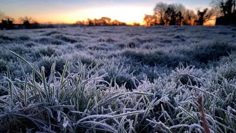 BBC Weather Watcher Becka
Northern Ireland has recorded its coldest night of this winter, with a very frosty start to New Year's Eve.
In Katesbridge, County Down temperatures as low as minus 7C were recorded.
Even colder temperatures are en route for the first few days of 2026.
It is expected that parts of Northern Ireland will see snow by the end of this week.
A yellow warning for snow and ice has been issued across Northern Ireland for the first half of Friday.
As the temperatures fall overnight icy stretches are likely to develop on untreated surfaces.
The Met Office warning lasts from midnight on Thursday until 10:00 GMT on Friday.
 Getty Images
On Wednesday, the dry, chilly spell of weather continues during daylight hours.
For those out and about on New Year's Eve night, patchy rain is to be expected at midnight across much of Northern Ireland and during the early hours with a freshening north-westerly wind.
New Year's Day, on Thursday, will not be as frosty and it should be a bright, breezy start to 2026, with some scattered showers falling.
Snow showers and ice
Arctic air will move south on Thursday night and Friday will be much colder with some sunshine but scattered sleet and snow showers have been forecast.
Temperatures will be bitter as a strong northerly wind will gust in coastal areas.
Daytime temperatures will drop below average and there will be a significant wind chill.
The Met Office warning for Friday includes a warning of snow showers early on in the day, especially across more northern areas.
These could lead to patchy snow accumulations of between 1-2 cm, especially on higher ground.
Some travel disruption is possible, as well as injuries from slips and falls.
This period of wintry weather will continue into the weekend and possibly the early part of next week.
By Monday morning, forecasts suggest over 15cm of snow on the higher ground around the Sperrin Mountains and 2cm-5cm on lower ground.
Parts of Counties Down, Armagh and Fermanagh will see little if any snow, with ice acting as an additional hazard.
