Snow and ice warnings issued as 2026 to begin with Arctic blast

- Published
Snow and ice warnings have been issued by the Met Office for New Year's Day and into the weekend.
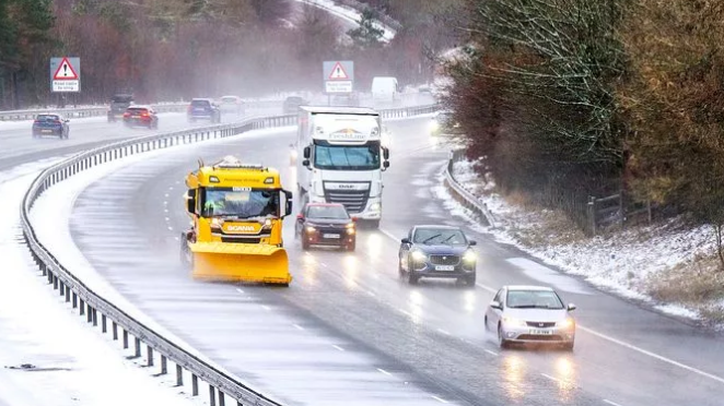
Travel disruption is likely with some large snow accumulations and blizzards.
The cold spell is likely to last over a week with amber cold health alerts issued across the whole of England by the UK's Health Security Agency (UKHSA).
If you are heading out tonight to celebrate New Year's Eve or Hogmanay then for most of the UK it will be dry with variable cloud.
Will it snow on NYE?
Overnight temperatures fell to -9.6C in Braemar, Aberdeenshire, -8.1C in Shap, Cumbria, -6.8C in Katesbridge, County Down and -6.4C in Sennybridge, Powys.
These are the lowest temperatures recorded so far this winter in all four nations of the UK.
However, lower temperatures were recorded in November which was meteorological autumn.
While it'll be dry for most of the UK tonight, some showers will affect Northern Ireland, central and southern Scotland and the far north of England.
There'll be a strengthening northerly wind that will make it feel cold though.
And as the clock passes midnight into 2026, we'll start to see snow showers coming into northern Scotland.

Frequent snow showers will move in across northern Scotland while another area of snow showers moves through Northern Ireland, Wales and into south-east England.
Cold health alerts from the UKHSA have been upgraded to amber for the whole of England and will be in place until 12:00 on 6 January.
The alerts warn of a rise in deaths particularly among elderly and vulnerable people.
Other consequences of cold weather include temperatures inside hospitals and care homes dropping below the levels recommended for assessing health risks, and challenges for people keeping indoor temperatures at the recommended 18C, according to the UKHSA.
Maximum temperatures by day will be around 0 to 7C over the next few days before dropping further.
The colder Arctic air will spread across the UK from New Year's Day - Thursday - with significant snowfall expected in Northern Scotland.
A Met Office yellow warning is in place here from 06:00 GMT Thursday until 23:59 Friday.
Snow accumulations could be around 2-10cm at low levels but up to 20-30cm over higher ground with some drifting and blizzards.
Delays on the roads with risk of vehicles being stranded are possible.
Some rural communities could also be cut off according to the Met Office.
There will be strong northerly winds too with an additional Met Office yellow warning for wind in north-east Scotland and the Northern Isles from 21:00 GMT Wednesday to 09:00 Thursday.
On Friday an area of snow showers will move across Northern Ireland, Wales, southern areas of North-West England, the Midlands and into southern England.
Snowfall may last a couple of hours, with 2-5cm possible at low levels so travel disruption is possible.
An additional Met Office yellow warning has been issued for midnight Friday until 12:00 GMT.
There could be as much as 5cm of snow over the higher ground of Wales and the southern Pennines.
By the end of this week temperatures will be up to 3-5C at best with some parts of Scotland and northern England experiencing 'ice-days' where temperatures don't rise above freezing.
How cold does it have to be to snow?
- Published30 December 2025
How do cold weather health alerts work?
- Published17 February
More significant snow?
Into the weekend there will be more snow showers piling into Northern Scotland and so there is another Met Office yellow warning here from midnight Saturday to 23:59 GMT Sunday.
A further 20-30cm of snow is likely to fall, on top of the snow falling on Thursday and Friday.
With strong northerly winds there will be some drifting of snow and temporary blizzard conditions are likely.
Lightning will be an additional hazard near showers.
Further snow and ice warnings are likely to be issued by the Met Office in the coming days, which you can keep up to date with here.
Away from the snow showers there will be lots of crisp winter sunshine.
With the colder weather expected to last into next week, forecasters are keeping an eye on a weather system that could bring more widespread snow even across England and Wales on Tuesday.
Stay up to date with the latest forecast on the BBC Weather website or app as details are likely to change.
Get in touch
How is the weather affecting you? Share your experiences if it is safe to do so.
- Published2 January

- Published2 January
- Published2 January