Amber warning for snow as freezing cold snap grips UK

 Danny Lawson/PA Wire
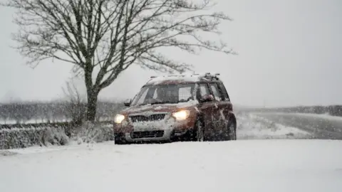
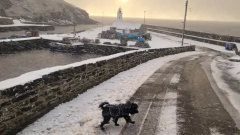
Wintry weather will continue across the UK on Thursday as temperatures fell below zero overnight and snow and ice hit some areas.
Met Office yellow warnings are in place for Northern Ireland, northern and eastern Scotland, and coastal areas in south-west Wales, and south-west, east and north-east England.
A more severe amber warning is in force in the North York Moors and parts of the Yorkshire Wolds, where as much as 15-25cm (6-10ins) of snow could fall on higher ground, causing significant disruption.
Snow and ice has disrupted road travel and closed dozens of schools in North and East Yorkshire in England, south-west Wales and northern Scotland.
More than 90 schools are shut in Aberdeenshire in Scotland and others have been forced to close in the Highlands and Moray. Dozens are also closed in Pembrokeshire, Carmarthenshire and Ceredigion in Wales.
The UK Health Security Agency (UKHSA) has also issued cold-health alerts for England until Saturday, saying there could be "significant" impacts to the elderly and people with health conditions.
Overnight temperatures dropped to -6.1C in Warcop, Cumbria in England, -5.8C in Sennybridge, Wales, -4.8C in Drumnadrochit, Scotland, and -2.8C in Altnahinch Filters, Northern Ireland.
Daytime temperatures in most areas of the UK on Thursday will reach between 2C and 6C.
 Owen Humphreys/PA Wire
 Owen Humphreys/PA Wire
 BBC Weather Watchers/Merch Cwmwl
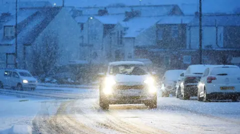
Sleet and snow showers will be driven in by wind from the north and mainly affect exposed coastal areas. Areas where showers or rain and sleet have left the ground damp are at risk of ice becoming a hazard on roads and pavements.
In Scotland, the A90 in Aberdeen was closed in both directions between Cleanhill roundabout and the Stonehaven roundabout on Thursday morning due to snow, with reports of many vehicles stuck.
The Met Office warned that in parts of Yorkshire under the amber warning, significant snow accumulation will disrupt travel and could close roads and interrupt power.
Some rural roads in the North York Moors were "impassable" early on Thursday morning, AA patrolman Ben Westney in Pickering told BBC Breakfast.
North Yorkshire Council said its crews were gritting priority roads, but urged caution as it said the action did not guarantee an ice or snow-free surface.
National Rail warned on Thursday that it may be necessary for speed restrictions to be put into place in areas hit by snow and ice, which could result in cancellations, alterations or delays.
Yellow warnings

There are yellow warnings for snow and ice on Thursday in:
- Cornwall and parts of Devon, and Carmarthenshire, Ceredigion, Pembrokeshire and Swansea until 23:59 GMT
- North East England, SW Scotland and Lothian Borders, Yorks & Humber until 23:59 GMT
- Central and northern Scotland until 21:00 GMT
- Norfolk, Suffolk, Cambridgeshire and Lincolnshire until 11:00 GMT
- Northern Ireland until 12:00 GMT
In these regions, expect 2 to 5cm of snow, even for low-lying areas, with perhaps as much as 10 to 20cm of snow for the highest ground in northern Scotland.
'Thundersnow'
Thursday's amber warning for North Yorkshire is in place from 03:00 to 21:00 GMT. Forecasters say snow is expected throughout the day, mostly on hills above 100m elevation and could lead to "substantial disruption".
They say it is possible some areas, including the North York Moors and the Highlands of Scotland, could see what is known as thundersnow.
It is is a phenomenon which happens when thunderstorms form in wintry weather and give rise to heavy falls of snow rather than rain.

For the rest of the UK, after a frosty start, Thursday should stay mostly dry with some sunshine, but there could be isolated wintry flurries and a risk of icy surfaces.
Areas from London to Shetland also saw snow on Wednesday, leading to dozens of school closures in Scotland and road closures in Derbyshire and north-west Wales.
 Graeme Smythe
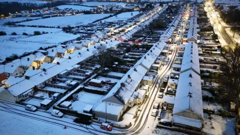 PA Media
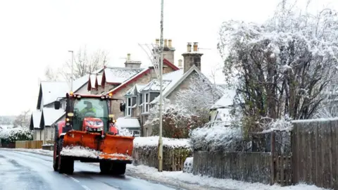 PA Media
Amber cold-health alerts have been issued in England by the UKHSA until 08:00 GMT on Saturday for the North West, North East, and Yorkshire and Humber, with all other areas under less-severe yellow alerts.
The alerts are mainly for health and social care services, warning of "significant" impacts to more vulnerable members of the community.
Extra demands may be put on services to deal with colder weather.
Temperatures are expected to become milder by the weekend, rising to average levels by Saturday.
Over recent decades the Met Office has observed a decrease in the frequency, duration, and intensity of cold spells, clearly linked to climate change. According to the latest State of the Climate Report, air and ground frosts have reduced by around a quarter since the 1980s.

Get our flagship newsletter with all the headlines you need to start the day. Sign up here.
