Ground truth: When the Earth moves, AI can spot it

 Getty Images
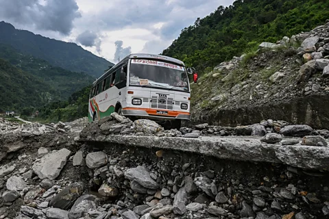
Sudden and unexpected, landslides and avalanches claim thousands of lives each year and cause billions of dollars in damage. What if we could see them coming?
All around the village of Kimtang, in central Nepal, are tell-tale signs that something isn't right. There are cracks in the concrete steps of houses, trees growing at strange angles – evidence that the ground is shifting beneath the villagers' feet. The question is, just how much is the ground moving?
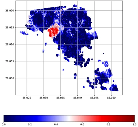
"This is not good," says Antoinette Tordesillas, a mathematician at the University of Melbourne, as she shows me an overhead view of Kimtang via Zoom. There's a large red spot on the image, which is not any old satellite image but a coloured map created by an artificial intelligence (AI) system.
The AI has identified a large unstable area, right beneath the village, colouring it bright red amid the dark blue of the rest of the hillside. It means the village sits right on top of a spot at high risk of a potentially devastating landslide. "Their village, where they live and farm, are actually on the slope," says Tordesillas. She and her colleagues have visited Nepal, and in some cases interviewed villagers about the slowly developing situation.
Landslides, she adds, might seem like sudden catastrophes that are impossible to predict. But satellite images captured using radar can reveal otherwise invisible signs of the ground starting to move days, weeks or even years in advance of a collapse. Granules of earth begin subtly separating from one another. "Dancers, if you like, following some kind of unwritten choreography," says Tordesillas.
In this precarious village in the mountains of Nepal, lives may be at stake. The AI-generated image is a warning. But it's also a chance.
Landslides are becoming more common, partly due to climate change, but also more direct human activities such as construction works and mining. In the US, landslides kill 25-50 people each year and cause billions of dollars in damage. Worldwide, they claim thousands of lives annually. Predicting when and where they will happen is incredibly difficult. But developments in AI are making it possible, helping geologists identify thousands of slopes around the world that are at high risk of slipping.
Nepal is home to some of the highest reaches of the Himalaya and is particularly prone to landslides and avalanches. In October 2025, a spate of landslides killed around 60 people in this mountainous country.
 Antoinette Tordesillas
While it's possible to monitor such places using satellites, or ground-based sensors, observing large areas in this way generates vast amounts of data. Analysing it manually would be "beyond human capability", says Tordesillas. Fortunately, well-established forms of AI such as machine learning can do this work.
"We use our knowledge of the physics of [slope] failure to guide AI," says Tordesillas. That is to say, this is a much more specialised system. That doesn't mean it could never make a mistake – but it does mean that scientists can try to ensure that it reflects their own deep knowledge of how landslides unfold.
Kimtang's villagers may be grateful for that. In 2019, they were relocated after a landslide struck a nearby area where they had been farming. "The unfortunate thing is, this area where they've been relocated to is the most unstable part in this whole region," says Tordesillas.
Getting the data to reveal this was, in part, a stroke of luck. It came from a European satellite called Sentinel-1, which bounces radar off the ground – at roughly 2,000 flashes per second – to map terrain in fine detail. Sentinel-1 happened to fly over this part of Nepal in just the right way. "The angle of the satellite on this particular village is such that we were able to get good measurements," says Tordesillas.
The latest imagery dates from January 2025 and, thankfully, no landslide has yet occurred there in the time since. But the information and analysis it allowed the AI to perform has given Tordesillas, and her partners at other institutions, an opportunity to inform villagers of the risk, work with them to develop ways of monitoring the situation at ground-level, and plan evacuation routes or muster points.
Again, the AI map could help with that.
 Antoinette Tordesillas
"The high school […] happens to be one of the most stable spots – that's something worth telling the mayor," says Tordesillas, who has also shared the AI analysis with government officials.
But this isn't the only place where AI is helping to identify communities that could be at imminent risk of a landslide.
Researchers in the UK, for example, are using AI algorithms to crunch Sentinel-1 radar imagery to analyse 300,000 slopes around the island of Great Britain. They have found 3,000 that are actively moving.
"We are talking about millimetres per year – it's something you don't notice with the naked eye," says Alessandro Novellino, a geoscientist at the British Geological Survey (BGS) who uses remote sensing to monitor for landslides. These tiny movements, however, could be a sign of a major slide likely in the future. And even if they don't lead to a major landslide, the movements over time will affect 8,700 miles (14,000km) of road and 220 miles (360km) of railway track.
It would take months or even years for humans do the same analysis that machine learning systems can do in a matter of minutes or hours, Novellino adds. "This is essentially enabling new science that we couldn't do in the past."
He stresses that the BGS does not have access to real-time data for this project since that is much more expensive. But, as in Nepal, data that is a year or two old can give you an indication of which slopes could be at risk of failing based on their historic movement.
In other situations, the BGS has used much more recent data to help analyse landslides after they have occurred. They did this last year, following deadly landslides on the Indonesian island of Sumatra. "We mapped more than 4,000 landslides in one go," says Novellino. "It affected half of the island, so it's a massive region."
He did this particular work voluntarily – using AI to analyse optical and radar imagery while working from home over a weekend. The BGS then shared the results with authorities in Indonesia, hoping that it would help emergency responders work out which roads and areas remained accessible, for example.
"The landslides inventory map produced by BGS was one of the first information products we received," a spokesman for the Indonesian National Research and Innovation Agency tells the BBC. "It was very useful as an initial reference to estimate the landslide distribution in Aceh Province, one of the three most affected provinces."
Separately, Network Rail, which owns and manages most of the railway network in Great Britain, keeps a close eye on the ground over which rail track runs. Landslides in such places can damage track and even lead to derailments. "We use AI enabled analytics to gather data from physical examinations, lineside sensors, drone surveys, and special inspection trains, which patrol our network – to help us identify and manage the risk of landslips," says a spokesman for the organisation.
Human teams use these tools to gain insight to ground movement. "This allows us to spot potential issues early and act quickly," the spokesman adds.
 Getty Images
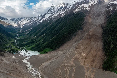
Acting quickly really matters when it comes to avalanches. Large falls of snow and ice on mountainsides are sometimes lethal. More than 100 people have died in avalanches in the European Alps this winter and nine skiers died in February when snow came barrelling down a mountainside in Lake Tahoe, California.
But one group of researchers realised that there was a rich source of data pouring out of the Alps, just waiting to be analysed.
"There are webcams all over the Alps," says James Fox, a Masters student at the Swiss Federal Technology Institute of Lausanne. He and his collaborators designed an AI tool able to spot avalanches when they occur. "We did need around 4,000 pictures [of avalanches] for the training models," he says. His co-author manually labelled these pictures so that a form of AI machine learning called deep learning could begin to recognise what an avalanche looks like. Once the manual labelling was done, the system found its own way of detecting an avalanche based on that human guidance.
"Deep learning is really good at these slightly harder tasks," says Fox.
Fox stresses that such a system should always have a human in the loop. "You can't just have a computer call the emergency services," he says. But, in principle, this tool could flag possible avalanches to authorities who could then dispatch rescuers, for example. The technology was trialled by the Avalanche Warning Service in Tyrol, Austria, during a recent winter season. A spokesman says it showed promise and has "significant potential for the future" but that in its current form it generated too many false positives – misidentifying rocks exposed by melting snow as avalanches.
These kind of tools, however, could also become a vital resource as climate change destabilises the permanent ice in mountain ranges such as the Alps, leading to rockfalls and landslides.
More like this:
In some parts of the world, however, AI is helping scientists to identify where landslides might be less likely than feared. Industrial engineer Ingry Natalia Gómez-Miranda at Pascual Bravo University Institution in Colombia and colleagues have analysed more than 180 records of landslides – including their geographic coordinates – in the city of Medellín, spanning the years 1981 to 2019. Using machine learning, they identified areas of the city prone to landslides, and then graded those areas in terms of risk from high to low.
This is important, says Gómez-Miranda, because it revealed that some locations where housebuilding has been banned may actually be safe. "If we recalculate the risk, we can let people build houses there," she says.
That said, some researchers who have combed through landslide data find it difficult to shake the feeling that the ground we walk on, far from being solid, is really rather mobile.
Mountains, for example, may seem to many people immovable, or rigid. Symbols, even, of fixity. But they're all in motion – they just move very slowly. Tordesillas' research has made her appreciate that. When she travels in Nepal these days, she finds it "difficult to relax", she says. "Now, I look at a mountain in a very different light."
--
For more technology news and insights, sign up to our Tech Decoded newsletter, while The Essential List delivers a handpicked selection of features and insights to your inbox twice a week.
