A red pixel in the snow: How AI solved the mystery of a missing mountaineer

 Getty Images
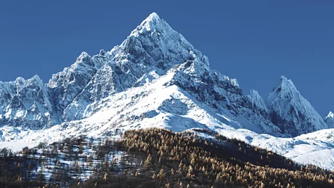
Scouring remote areas for missing walkers and climbers can take rescuers weeks and sometimes months. AI can do the job in a matter of hours in some cases – and potentially save lives.
Racing against worsening weather, mountain rescue teams in the Italian region of Piemonte were facing a puzzle. An experienced Italian climber and orthopaedic surgeon Nicola Ivaldo had gone missing. The 66-year-old had failed to show up show up at work on Monday and an alarm was raised.
Ivaldo had set out alone one Sunday in September 2024. Unfortunately, he hadn’t shared details of where he was headed with friends or family. The only clue to his whereabouts was the car that rescuers had found parked at the village of Castello di Pontechianale, in the Valle Varaita. From there, rescuers speculated, Ivaldo had probably gone to climb one of the two most prominent peaks of the Cottian alps – the jagged 3,841m-high (12,602ft) Monviso or its neighbour Visolotto, at 3,348m (10,984ft). This matched the last signal from his mobile phone, traced roughly in this area.
But this left the search and rescue teams with an enormous area to scour – the vast, rocky faces of each mountain have a number of routes leading to the summits from different sides. The whole area is criss-crossed by hundreds of miles of trails, explains Simone Bobbio, a spokesperson for the Mountain and Speleological Rescue Service of Piemonte.
The day Ivaldo went missing, excellent weather had attracted crowds on the most popular routes. No one had reported seeing him on the well-travelled paths. It meant that Ivaldo, a well-trained mountaineer, had probably gone to one of the more remote parts of the mountains.
More than fifty rescuers searched the area on foot for nearly a week, while a helicopter flew multiple sorties in the hope of spotting him from the air. By the time the early snow arrived in late September, any hope of finding him alive had faded and they aborted the search.
In July 2025, however, the search for Ivaldo's body resumed after the snow had largely melted from steep mountain gullies, or couloirs.
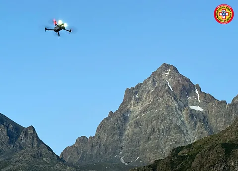
But this time the Piemonte rescue service brought in some additional help – artificial intelligence. They employed AI software capable of analysing thousands of photos taken by drones that could fly close to the rock walls and up the many gullies that streak the mountain flanks. It took just five hours for the two drones to capture the images and they were analysed the same day to identify spots where rescue teams could focus their search. Unfortunately poor weather conditions delayed the operation to then visit these sites with the drones to take a closer look.
 CNSAS
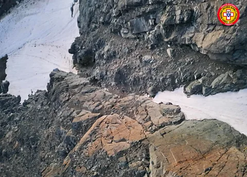
CNSASThree days after the search resumed, however, the body of the missing doctor was found at one of the sites identified by the AI, lying in a gully on the north wall of Monviso at an altitude of around 3,150m (10,334ft). His body was recovered by helicopter.
"The key was a red helmet identified as a point of interest by the software," says Bobbio.
Although tragically too late for Ivaldo, this field test of AI-powered search and rescue demonstrated how useful the technology could be in the future when people go missing. It hadn't been possible to deploy the technology in the initial search, but rescue teams hope it could be used in combination with traditional rescue operations for when searching for people who might still be alive.
The use of drones during the search for Ivaldo's body was a crucial element in finding him. Their size and manoeuvrability meant they could quickly cover the difficult terrain, get close to the rock walls and provide views that are not possible from a helicopter.
The drone pilots had visited the area several times during the winter and spring to practice flying in the mountainous environment.
"We gathered all available information about the terrain from the previous mission and studied climbing paths that might have attracted Ivaldo," says Saverio Isola, drone pilot and chief of the mountain rescue station in Torino. This allowed them to identify priority areas to search.
A helicopter dropped two drone pilots high on the mountain slopes and closer to rocky faces and couloirs. They covered 183 hectares (452 acres) of the mountainside with the drones, taking more than 2,600 high-resolution photos.
"Until two years ago, we would be analysing these photographs by ourselves, each and every one of them", says Isola. But in 2023, Italian mountain rescuers began experimenting with a few existing AI software programs that are trained to identify significant discontinuities in colour or texture in the landscape. It means that the analysis of the images can be done in a matter of hours.
The AI picked through the pictures taken by the drone pilots pixel by pixel, looking for anything that might look out of place on the mountainside. The software identified dozens of potential anomalies from a large number of photographs in a matter of hours.
The selection, however, still needed to be whittled down with some human expertise.
"The software could react to different things, like a piece of plastic garbage or an unusually coloured rock," says Isola. "It can even hallucinate some things. So, we still had to narrow it down further by taking into consideration the path that Ivaldo, as a very skillful climber, might have used."
They ended up with three possible locations, including one that contained a red object.
The next morning, when the drones went to check the spots, the red object in one of the photos turned out to be Ivaldo's helmet. This led rescuers to quickly discover the body of the missing doctor, still partially covered in snow and dressed in black. Without the AI flagging the red dot in one of the drone photographs, he may never have been found.
"The software managed to detect the red colour even though the helmet was in shade when the image was taken," says Bobbio.
This wasn't the first time this kind of AI technology has been successfully used in a search mission.
In 2021, software developed by a spinoff company from the University of Wrocław in Poland, was instrumental in the rescue of a missing 65-year-old man missing in Beskid Niski, in the south east of the country. Time was of the essence in this case, since the man had Alzheimer's disease and had suffered a stroke the day before he went missing.
Software called SARUAV analysed 782 aerial images of the area and detected the missing person in a little over four hours, providing the Bieszczady Mountain Rescue Service with his coordinates. It was believed to be the first time this type of automated human detection system was directly involved in a rescue.
Two years later, the same algorithm was used to locate the body of another missing person in the Austrian part of the Alps. Other software that searches for unusually coloured pixels in natural landscapes – developed by the Lake District Search and Mountain Rescue Association in the UK – has been used to locate the body of a missing hillwalker in Glen Etive in the Scottish Highlands in 2023.
But this technology still has many limitations when it comes to rescue missions. Drones are almost useless in certain terrains, such as those with forests and dense vegetation, or in any low-visibility conditions. And existing AI software capable of detecting anomalies in aerial images still require some fine-tuning.
Experts from the Croatian mountain service, for example – one of the first in the EU to start using drones back in 2013 – told the BBC that AI programs of this type give too many misleading results in typical Croatian mountain terrain. The mix of vegetation and a complex karst landscape full of different rocky shapes confuses the AI algorithms.
The key is to keep training the machine learning systems that power these algorithms to improve their accuracy in different types of terrain and conditions, says Tomasz Niedzielski, an expert in geoinformatics at the University of Wrocław and leader of the team that developed the SARUAV software.
Finding a human shape against a diverse terrain in images, he explains, has some additional challenges.
"The most suitable area for use of algorithms like SARUAV is wide, open terrain in wilderness, where there is no overwhelming presence of people and less chance for the algorithm to produce more false positive results," says Niedzielski.
 CNSAS
CNSASDaniele Giordan, leader of the GeoHazard Monitoring Group at the Italian Research Institute for Geo-Hydrological Protection (IRPI), whose work involves the use of unmanned aerial vehicles for engineering geology applications, also warns about the ethical challenges in the use of algorithms that search for missing humans.
"Once you acquire aerial images, you have a responsibility for how to use them," he says. "Identifying human shapes in images could be a legal problem."
As a mountain rescuer himself, Giordan is collaborating with the geomatics team at Politecnico di Torino University to develop an improved algorithm that would give more accurate information to rescuers. This includes a more precise geo-referenced location of every suspicious sign that the AI identifies on the images, which would make checking them out more efficient.
"Our idea is to develop a more complete software, able to analyse all the data sets from the search activities and to manage the teams on the field and the drones inside the same system," says Giordan. "The future challenge will be to incorporate these complex analyses directly on board of the drones and during the SAR flight." This could eventually allow images of a landscape to be analysed in real time as a search is ongoing.
There are other research teams working with rescue organisations to use AI in different ways to improve search operations.
Researchers at the University of Glasgow in the UK, for example, recently unveiled a machine learning system that creates virtual "agents" to simulate how a lost person might behave. They used data based on accounts of how people act in the real-world after becoming lost outdoors. The aim is to produce a map of locations where searchers can focus their efforts. Unlike using images from drones, this kind of predictive approach can be used in difficult terrains such as forests.
Faced with the urgency of finding someone before they succumb to injuries or the weather, but also struggling with limited resources, such algorithms could become a important tool for search and rescue services, researchers believe.
Ultimately, it could save lives.
--
For more technology news and insights, sign up to our Tech Decoded newsletter, while The Essential List delivers a handpicked selection of features and insights to your inbox twice a week.
For more science, technology, environment and health stories from the BBC, follow us on Facebook and Instagram.
