Is Goretti the worst storm to hit the South West?

 PA Media
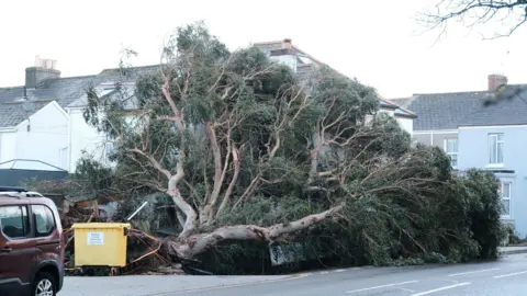
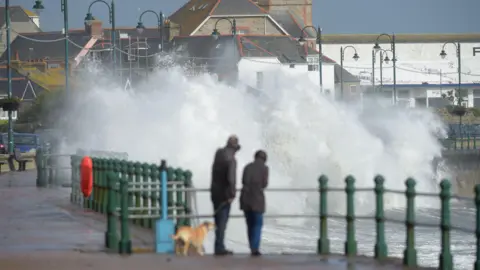
I have been studying the weather since 1982 and as you can imagine have seen a fair amount of bad conditions from snow to torrential rain and of course more recently our named storms. With widespread damage caused by Storm Goretti on 8 January, how does it compare to others I have covered in the South West and Channel Islands, and those before my time?
The most memorable perhaps is the 'Great Storm of 1987', this was before storms were named which started in the winter season of 2015/2016.
On the night of the 15 October 1987 and into the following morning the winds across the South West peaked at 98mph at Jersey Airport.
It has been referred to as the worst storm since the Great Storm of 1703 and described as a once in 200 year event.
In 1703 there were not that many actual wind speed reports, rather the records illustrating the damage caused, including the weakening of a brand new lighthouse on the Eddystone rock south of Plymouth, which was swept away two weeks later with a loss of all hands in another storm.
Another storm on 25 and 26 October 1859 had sustained winds over 73mph, or hurricane strength. There are not precise records as to how strong the gusts of wind were but they were estimated to be close to 100mph.
A total of 133 ships were sunk during the storm and another 90 badly damaged according to the Board of Trade records, and this led to the first gale warning service in the recently established Met Office.
 Met Office
Since then we have had numerous deep areas of low pressure, some the remnant's of tropical cyclones, or ex hurricanes, that have crossed the Atlantic and brought with them torrential rain and exceptional winds, but it seems that our own "home grown" storms have more potency and more potential to cause destruction.
In 1979 a 118mph gust hit Gwennap Head in Cornwall believed to be the strongest gust of wind since 1703.
To achieve winds close to 100mph in the gusts and averaging 60 to 65mph needs some very precise ingredients.
To start with the jet stream, a core of fast moving winds high up in the atmosphere, has to be in the right place at the right time but must also have the right shape.
Beneath that, close to the surface, has to be a baby low pressure system ripe for development.
The two combined create a process called "explosive cyclogenesis" - a term us weather folk describe as rapidly deepening and strengthening areas of low pressure where the pressure drop is at or quicker than 24mb in 24hrs.
How does the jet stream drive Explosive Cyclogenesis?
High-altitude winds in the jet stream, particularly in troughs (areas where the stream dips south), pull air upward and away from the low-pressure system below, and this is called upper-level divergence.
If you like this hoover or sucking action high up reduces the weight of the air column, causing the central pressure at the surface to fall rapidly.
As the surface pressure drops, air rushes in from surrounding areas, converging and increasing the storm's spin (vorticity), leading to faster rotation and stronger winds similar to a skater holding their arms in and increasing the rate of rotation.
In addition to this rapidly deepening low pressure system a 'sting jet' can develop within it.
This is a narrow core of strong gusts of wind which starts in the middle atmosphere several kilometres above the surface and gradually lowers over two to four hours, finally reaching the surface.
As the jet of air is descending rain and sleet/snow is also falling into it, cooling it and further helping it sink but also accelerating its wind.
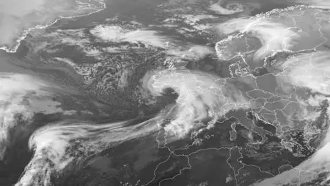
Then finally it reaches the surface as "sting jet" or the sting in the tail of the storm often clearly seen on the satellite picture as a hook of cloud.
 EUMETSAT
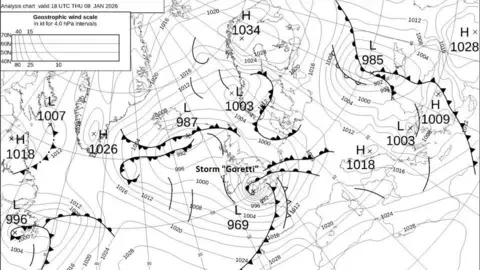
Storm Goretti's pressure drop was quite impressive from midnight on 7 January to 1800Z on 8 January.
In the space of 18 hours the pressure drop was over 30mb easily reaching the criteria to be described as a 'weather bomb' or undergoing explosive cyclogenesis and it also had a sting jet.
Of course there have been many notable storms since 1987, the Burns Day storm of 25 January 1990 had gusts of wind of 107mph (93kts) at Gwennap Head, and 102mph (89kts) at RNAS Culdrose, with Plymouth at 96mph. Ex hurricane 'Lily' gave a gust of wind of 90mph on 28 October 1996 in the Channel Islands.
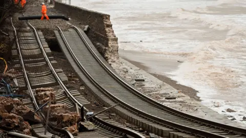
More recently in early February 2014 a series of storms battered the South West, the fourth of which was on 4 and 5 February where there was widespread damage.
Both the Isles of Scilly and south Devon had gusts of wind in excess of 90mph and it had a huge impact with the railway line at Dawlish washed away and devastating floods across the Somerset Levels.
 PA Media
Storm Eunice on the 18 February 2022 had one of the strongest gusts of wind ever recorded in the UK at 122mph (106Kts) at Needles Old Battery (Isle of Wight) and 90mph (78Kts) at Isle of Portland in Dorset.
More recently Storm Ciaran on 1 and 2 November 2023 with the devastation caused by 93mph gusts of wind in the Channel Islands, and the local Met Service issuing a red weather warning, schools and shops being closed and a major incident being declared.
In northern France a reported 1.2 million people were without electricity. Storm Eunice was, by the way, another rapidly deepening low pressure system undergoing the "weather bomb" criteria.
 PA Media
On 6 and 7 December 2024 Storm Darragh brought a huge amount of disruption with gusts to 83Kt (96mph) at Berry Head, Devon.
Back to Storm Goretti and with peak winds of 99mph for the South West of England and the Channel Islands, it was not the worst storm ever.
In fact the description as to how bad a storm is must not just be about wind speed, but must include flooding, disruption, sadly the loss of life, and the impact to our daily lives.
If you base the assessment purely on wind gusts then it's not as windy as the Burns Day storm of 1990, but Goretti had winds actually stronger than the Great Storm of 1987 and that of storms Eunice and Ciaran in the South West of England.
So in my opinion based just on wind gusts, Storm Goretti is in the top five of the most powerful storms in the South West on record with 1703, 1859, 1979, and the Burns Day storm of 1990 being stronger.
Perhaps the most sobering fact about our recent storms is that what was once a one in 200 year event is now far more frequent with some of our strongest storms on record being in the last 20 years.
