Weather warnings spark risk of flood and travel disruption

 Pacemaker
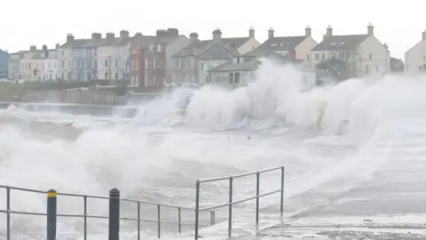
The Department for Infrastructure's (DfI) roads and rivers teams are on stand-by "ready to respond" amid multiple weather warnings for heavy rain and flooding across Northern Ireland.
Following a meeting on Thursday, the DfI said that it may be "necessary to close roads or put temporary restrictions in place".
The Met Office has issued a yellow rain warning for counties Antrim, Armagh, Down, Londonderry and Tyrone, in place until 23:59 GMT on Friday, while a status orange which was in place for parts of the Republic of Ireland has now ended.
The warnings come after weeks of heavy rain and flooding in some areas.
 Pacemaker
Some road flooding is possible especially in the east and south eastern areas and along coastal routes, and the public are reminded to take extra care when travelling.
Road users have been advised of flooding in the Warrenpoint Road area of Rostrevor where traffic has been impacted in both directions.
The Police Service of Northern Ireland (PSNI) have urged drivers to exercise caution and seek alternative routes where possible.
Jason Carnduff, owner of Saints N Sinners restaurant in Donagahee, said he had to close his business early on Thursday due to flooding.
He described how parts of the sea wall along the parade have crumbled due to flooding and adverse weather over recent weeks.
"The whole road was flooded, every time the door opened, there was two inches of water coming in, it was crazy," he told the BBC's Evening Extra programme.
"I actually had to get customers, lead them out the back door and drive them round to their car at the front, the waves were actually moving the cars in the street".
 Getty Images
According to the Met Office, most places will receive between 10-20 mm of rain.
Showers are expected to be persistent in parts of the Mourne Mountains and Antrim Hills.
Given the record-breaking amounts of rain that fell in January, the ground is saturated and very sensitive to further rainfall.
Impacts of flooding may be low in many areas but in parts of Counties Down and Antrim, disruption is likely to be more significant
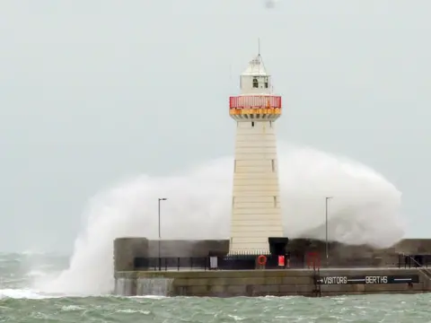
Southeasterly winds will be strong to gale force in coastal areas and large waves may form along parts of the east coast leading to hazardous travelling conditions.
There is also a possibility of isolated power cuts and disruption to other services, while flooding of a few homes and business businesses cannot be ruled out.
All remaining Stena Line sailings out of Belfast on Thursday have been cancelled, while the 03:30 GMT sailing from Belfast to Cairnryan on Friday morning was rescheduled.
Allow X content?
Republic of Ireland
A status orange rain warning which was in place for Louth, ended at 12:00, so did a status yellow rain warning in Cavan, Monaghan, Dublin and Meath.
An earlier yellow warning for rain in counties Carlow, Kildare, Kilkenny, Laois, Wexford and Tipperary ended at 09:00.
A status orange warning for rain in Dublin and Wicklow has also ended.
In a nationwide weather advisory, Irish forecaster Met Éireann warned that flooding is likely due to a combination of already saturated ground, high river levels and high tides.
The Road Safety Authority has urged drivers to take care on the roads.
Dublin City Council said it was monitoring river levels and coastal conditions closely to "ensure appropriate responses as required".
It said its crews were active across the city, with removal of debris at rivers and blockage clearing ongoing to minimise negative impacts.
The council has a "limited supply of sandbags at strategic locations for use in response to identified flooding risks".
Wicklow County Council said it was in a "state of readiness" ahead of the Status Orange warning.
It said it had taken a number of preventative measures, including replenishing stocks of sandbags, closing roads subject to flooding and structural damage, and crews working to clear drains and gullies that have become blocked with flood debris.
In Waterford, the council said high tide had passed on Thursday morning and flood defence barriers had been effective.
Weather stations at Dublin Airport and Phoenix Park in Dublin both recorded their wettest January since 1948.
A study carried out between Maynooth University and Met Éireann found that the amount of rain over eight days, including during Storm Chandra, was three times more likely due to climate change.
