Storm Bram alerts as 90mph gusts and heavy rain to batter Scotland

 Reuters
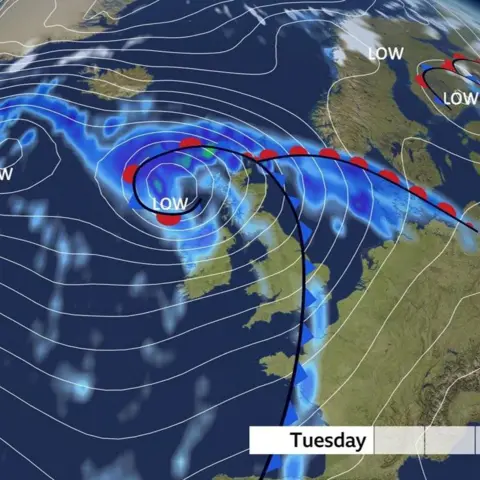
Severe weather warnings have been issued for Scotland ahead of the expected arrival of Storm Bram.
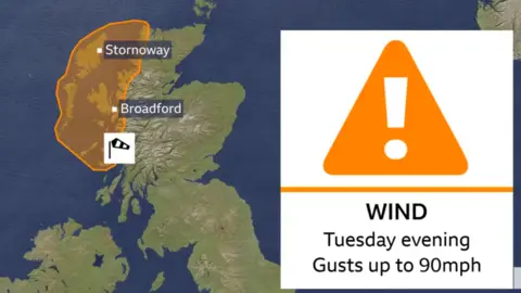
The Met Office has issued an amber wind warning for north-west Scotland which takes effect from 16:00 until midnight on Tuesday, with gusts of 70-80mph expected for a few hours. This could reach 90mph in some places.
Storm Bram, which was named by the Irish weather service Met Éireann, is also forecast to bring high winds and heavy rain to the rest of Scotland.
The Met Office has issued a number of yellow warnings for wind covering the whole of Scotland on Tuesday and Wednesday.
Storm Bram is the second named storm of the season.
It follows Storm Amy in October which caused travel disruption and power cuts across tens of thousands of homes in Scotland.
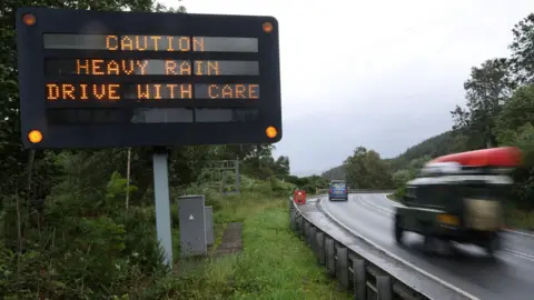
This time heavy rain could bring travel disruption in places, and there is a slight chance of power cuts and loss of other services to some homes and businesses.
The Met Office has also warned of possible flooding to homes and buildings, and delays or cancellations to train and bus services.
Strong winds could also cause delays to road, rail, air and ferry transport alongside buses and train services.
Coastal regions could also be affected by large waves.
What Met Office warnings have been issued?
Wind:
- An amber warning is in place for the Western Isles, north-west Highlands and Argyll and Bute from 16:00 to midnight on Tuesday. Very strong south-westerly winds could result in gusts of 70-80mph widely, and up to 90mph in a few places.
- A yellow warning has been issued for north and north-east Scotland, Argyll and Bute and parts of central Scotland from midday on Tuesday to midday on Wednesday. Gusts of 60-70 mph are expected fairly widely, but gusts of 70-80mph are possible across the Hebrides and western Highland.
- A yellow warning has also been issued from midday Tuesday to 06:00 Wednesday for eastern Scotland, central and Southern Scotland as well as parts of northern England and Wales. Gusts of 50-60mph are possible widely, and potentially in excess of 70mph for some exposed headlands and high ground.
Rain:
- A yellow warning has been issued taking effect from 06:00 to midday on Tuesday. A spell of heavy rain is expected to move north across the central Scotland, including Perth, Stirling, Glasgow and Edinburgh.
The Scottish Environment Protection Agency (Sepa) has issued 12 flood alerts.
They cover larges parts of Scotland, including Argyll and Bute, Orkney, Western Isles, Tayside and Dumfries and Galloway.
Sepa said there was a risk of coastal flooding on Tuesday due to a combination of very strong winds, a storm surge and spring tides.
It said heavy and persistent rain could cause some minor flooding impacts from smaller rivers and surface water.
Will travel be disrupted?
 Reuters
BBC Scotland senior weather presenter Kirsteen Macdonald said a spell of very high winds and heavy rain had been forecast a large area of the west coast.
"These winds will be disruptive to transport and travel, with the risk of power cuts and large waves bringing coastal flooding," she said.
"Heavy rain will accompany these high winds and may exacerbate impacts."
The presenter said yellow wind warnings had been issued for other parts of Scotland.
She added that some places covered by the yellow warning for heavy rain could have 20-30mm - about an inch - of rain with most of it falling in a four to six-hour period.
"Some places over high ground may see up to 40mm of rain," said Ms Macdonald.
"This will lead to very poor travelling conditions from surface water and spray, as well as the risk of localised flooding."
She said the conditions were expected to ease during Wednesday.
West coast ferry operator CalMac has warned customers to expect cancellations and delays.
Network Rail said passengers should check their journeys before travelling.
It said speeds would be reduced on some routes for safety reasons.
- From early Tuesday morning there will be lower speeds on parts of the West Coast Main Line and routes between Glasgow, Ayrshire, and Dumfries and Galloway due to heavy rainfall
- From Tuesday afternoon speed restrictions will be applied to the Mallaig Line, Oban Line, and West Highland Line and remain in place into Wednesday morning
- From Tuesday evening there will be similar limits on the Far North Line and sections of the Highland Main Line and Aberdeen–Inverness route until early Wednesday
Route director Ross Moran said: "Storm Bram is expected to bring strong winds and heavy rain, which could disrupt the railway.
"Our top priority is keeping passengers and staff safe, and we're already working hard behind the scenes to prepare."
Transport Secretary Fiona Hyslop said challenging weather was expected.
She added: "The Met Office warnings show high winds will impact the whole country, particularly in parts of the north-west and Western Isles covered by the amber warning, so it's vital people plan ahead if they have to travel."
Western Isles local authority Comhairle nan Eilean Siar said school buses in Uist had been cancelled for Tuesday, but all schools were expected to be open.
