Storm Dave to 'deepen' as amber wind warning sets in for parts of UK

 Getty Images
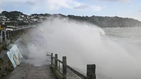
Storm Dave will "continue to deepen" on Saturday evening as an amber warning for "disruptive and potentially damaging" winds covers parts of the UK, the Met Office has said.
The storm will bring heavy rain and snow as it moves north-eastwards into Easter Sunday, with the upgraded warning covering northern England, north-west Wales and southern Scotland until the early hours.
The Met Office warned of potential danger to life from flying debris and travel disruption, while electricity operators said the storm had heightened the risk of power cuts.
Yellow warnings will cover parts of all four nations overnight as Storm Dave sweeps across the country, driving wet and windy weather into Easter Sunday.
Those travelling over the Easter weekend have been warned of possible disruption on the roads as well as ferry, rail and air services.
Some ferry services have been cancelled and amended in western Scotland, with rain, sleet and hill snow reported in the region on Saturday afternoon.
Up to 30cm of snow could fall in parts of the country, where a yellow warning has likewise kicked in, with the Met Office warning of "strong wind blizzards and drifting snow" posing a further hazard.
ScotRail urged passengers to check their journeys before travelling while Highlands and Islands Airports warned flights could be affected.
Holiday sites in Wales have meanwhilereported cancelled stays over the blustery conditions, as gusts ofup to 66mph were recorded in Capel Curig in the north.
But coastal areas covered by the amber wind warning could see speeds hitting 80mph before it expires at 03:00 BST on Sunday, the Met Office said, where large waves and debris will mean injuries and danger to life are likely.
Meanwhile, the Energy Networks Association, which represents electricity network operators, warned of a hit to local power infrastructure - with a greater chance of power cuts and fallen power lines.
It said operators were increasing staffing and moving equipment to the areas expecting the worst weather.
In Northern Ireland, where a yellow warning for wind came into effect at 14:00, some council facilities are closed and visitors have been advised to stay clear of parks and nature reserves.
In England, National Highways said people should plan ahead and adjust their travel plans as the RAC warned extra care should be taken on exposed, higher routes.
People have been advised to stay indoors as much as possible, and check for loose items outside that need securing.
Met Office chief meteorologist Chris Bulmer said wind speeds were expected to pick up first in Northern Ireland early on Saturday afternoon, before "spreading more widely across the north of the UK".
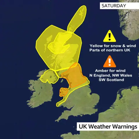
The separate warnings are:
- A yellow wind warning covering all of Northern Ireland from 14:00 on Saturday to 03:00 on Sunday
- A yellow snow warning covering the west Highlands, Argyll and the Western Isles from 14:00 on Saturday until 03:00 on Sunday
- A yellow wind warning covering northern England, southern Scotland and northern Wales from 17:00 on Saturday to 07:00 on Sunday
- A yellow wind warning for almost all of Scotland from 18:00 on Saturday to midday on Sunday
- An amber wind warning covering southern Scotland, northern England and north-west Wales from 19:00 on Saturday to 03:00 on Sunday
- A yellow wind warning for Orkney and Shetland from midnight on Sunday until midday
Storm Dave will slowly loosen its grip on Easter Sunday as it continues its path eastward, although strong winds will continue across Scotland, Northern Ireland and northern England.
Further south, there will be sunshine and showers - although these areas are set for cooler conditions than on Saturday.
After a chilly start to Monday, temperatures will climb through the day to reach afternoon highs of 10-15C (50-59F), with dry and sunny spells for most.
Tuesday looks set to turn even warmer with 20C looking possible in parts of England and Wales.
