What caused north-west England earthquake?
When an earthquake shook homes in a small Lancashire village, those living there felt as though "the roof was falling in".
The tremor in the north-west of England on Wednesday was so powerful, emergency services thought there had been an explosion and it was felt across the country.
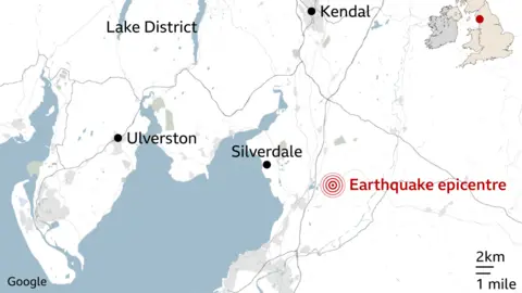
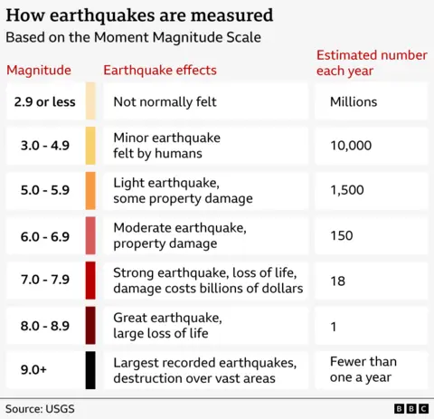
It struck at about 23:23 GMT, and registered a magnitude of 3.3, with its epicentre tracked to the village of Silverdale.
What caused the earthquake?
Experts at the British Geological Society (BGS) said they could not pinpoint exactly how this earthquake happened.
Because the quake occurred about 3km below the earth's surface, they said it was difficult to link it with particular fault lines that geologists have mapped across the UK.
These types of quakes are caused by small movements on geological faults in the Earth's crust, activity which is unpredictable and not impacted by the time of year, the spokesperson added.
In general, earthquakes are caused by the tectonic plates that make up the earth moving and rubbing together.
The UK is situated within the Eurasian plate, more than 1,600km away from the nearest plate boundary, which is why it does not experience earthquakes as big as other parts of the world.

Are earthquakes common in the UK?
Wednesday's earthquake was "not out of the ordinary", according to the BGS.
In fact, the UK can experience several magnitude-3 earthquakes every year, with one being recorded in Scotland in October.
Magnitude-4 quakes are less frequent, and occur every three to four years.
Smaller earthquakes in the UK are much more common, with BGS recording 200 to 300 per year.
However, only around 20 to 30 of them are strong enough to be felt, and most don't cause any damage.
Has there been an earthquake there before?
The BGS said the most recent earthquake of a similar size was in 2009, when a 3.7-magnitude earthquake hit the Morecambe Bay region.
There was also a magnitude-2.9 quake recorded in the region in 1993.
What was the UK's biggest earthquake?
The largest known earthquake in the UK occurred near the Dogger Bank, in the North Sea off the coast of Yorkshire, in 1931.
It had a magnitude of 6.1 and was powerful enough to cause minor damage to buildings on the east coast of England despite its epicentre being 60 miles offshore.
Otherwise, centuries of observations suggest that damaging earthquakes in the UK are quite rare.
Listen to the best of BBC Radio Lancashire on Sounds and follow BBC Lancashire on Facebook, X and Instagram. You can also send story ideas via Whatsapp to 0808 100 2230.
