Flood warnings issued as river bursts its banks

 BBC
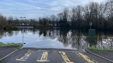
BBCFlooding has hit parts of Surrey after the River Bourne burst its banks.
Parkland off Free Prae Road in Chertsey is underwater, with footpaths now inaccessible and a nearby car park has also been flooded.
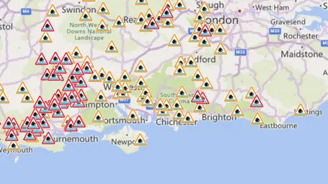
Two flood warnings are in force in Surrey, covering areas closest to the Chertsey Bourne and stretches of the Thames around Shiplake, Lower Shiplake and Wargrave.
Three further warnings are in place in West Sussex, where flooding is expected at Barcombe Mills on the River Ouse, Fittleworth on the Western Rother and Pulborough on the River Arun.
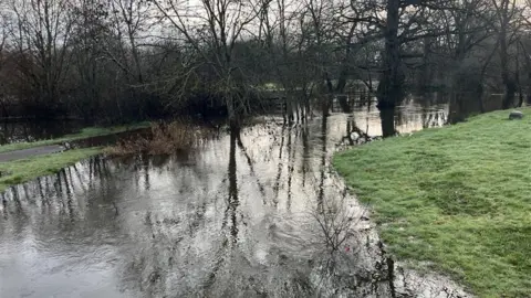 Julia Gregory/BBC
The Environment Agency says high water levels are expected to persist with further flooding possible on low‑lying roads.
There are 19 additional flood alerts active across Surrey and neighbouring areas.
They cover areas around rivers including the Chertsey Bourne, Colne Brook, the Lower Loddon, the Mole, the Wey and stretches of the Thames, as well as groundwater‑affected areas such as Godalming, Haslemere and Churt.
Six warnings have been lifted in the past 24 hours as levels ease in some locations, including those for the Rivers Eden and Eden Brook, and the Hoe Stream.
 Environment Agency
In Sussex, the River Ouse at Barcombe Mills remains high but levels are falling, with minor flooding still affecting fields and roads, the Environment Agency says.
Warnings also remain in place on the River Arun at Pulborough and on the Western Rother at Fittleworth, where levels are easing but could rise again with more rain.
When will the rain stop?
A Met Office yellow warning for rain comes into force at 12:00 GMT on Monday until 23:59 for parts of south and south west England.
The Met Office said: "10-15mm (0.6in) of rain is likely fairly widely with 20-30mm in some places exposed to the strong south to south-easterly winds."
BBC weather forecasters say spells of rain will continue at the start of the week but it looks like higher pressure will start to build across the north of the UK later in the week.
They said it may "turn things a little drier and possibly even brighter. It is also expected to turn a little colder".
They said wet weather is still likely to affect the south of the UK, perhaps turning to snow where it meets cold air, but even here there are signs of something a little drier and colder arriving - perhaps by the following weekend.
Follow BBC Surrey on Facebook or X. Send your story ideas to southeasttoday@bbc.co.uk or WhatsApp us on 08081 002250.
