Erosion sparks safety fears on King's coast path

 Amanda White / BBC
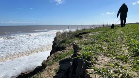
Concerns have been raised about rapid erosion affecting a stretch of the new King Charles III England Coast Path.
The route covers the entire coastline of England and was inaugurated by the King last week.
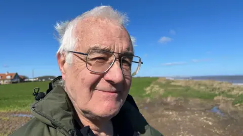
But rambler Alan Tharratt said sections in Holderness, East Yorkshire, were eroding "very quickly". He added: "I've been mountaineering all my life and there's a level of risk you have to accept... but I wouldn't walk close to this cliff."
Natural England said the path was "designed to move in response to coastal change" and it would always try to "maintain a usable route".
Holderness has one of the fastest eroding coastlines in the UK, with parts of the coast losing about 15ft (4.5m) on average per year, according to the East Riding of Yorkshire Council.
While the path is designed to "roll back" when erosion occurs, Tharratt said: "It's eroding very, very quickly and it's unpredictable. You just don't know when it's going to go."
 Amanda White / BBC
Some of those using the path near Mappleton have had to walk over a farmer's field, away from the cliff edge.
Walker Chris Hine said: "It just doesn't seem very defined for a new footpath."
Dave Bower added: "It's a good idea generally, but it's a bit hit and miss.
"There's obviously bits fallen in and there's no guidance as to where's safe to walk and where isn't."
The King Charles III path runs for 2,689 miles (4328 km), making it the longest managed coastal walking route in the world, according to Natural England, which spent 18 years creating it.
It passes through some of the country's most beautiful and varied landscapes, from salt marshes and sandy beaches to cliffs, dunes and historic coastal towns.
While the route has been inaugurated, only about 80% is open, with most of the rest due to be completed by the end of the year.
 Amanda White / BBC
Tharratt said some of the route's signposting and infrastructure was incomplete, including a section near the village of Skipsea, which diverts around a holiday park.
"There's supposed to be a tarmac path along the roadside as part of the diversion," he told BBC Look North.
"They've said it's open, but it clearly isn't."
The route is maintained by Trail Partnerships, incorporating local authorities, national park authorities and other organisations through whose land the trail passes.
Natural England said the path would evolve "through a process known as rollback, which is particularly necessary in fast eroding coastal sections like Holderness".
It added: "There will be some temporary diversions in place until a new route can be discussed with landowners and works can be actioned, but we will always endeavour to maintain a usable route."
Clarification 30 April: This article has been updated to make clear that parts of the coast have an average erosion rate of 15ft per year as per the local authority's website.
Listen to highlights fromHull and East Yorkshire on BBC Sounds, watch the latest episode of Look Northor tell us about a story you think we should be coveringhere.
Download the BBC News app from the App Storefor iPhone and iPad orGoogle Play for Android devices
