Iran school and nearby military base struck multiple times, satellite image reveals

 Anadolu via Getty Images
Warning: this story contains details which some readers might find distressing
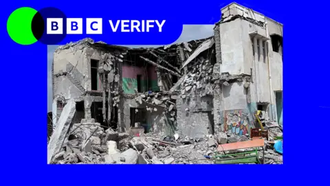
Satellite imagery analysis reveals multiple strikes and burn marks around a school in southern Iran, suggesting it was hit more than once, in an attack Iranian authorities say killed 168 people on Saturday.
Verified videos and satellite imagery show extensive damage around the Shajareh Tayebeh primary school in Minab and the adjacent Iranian Revolutionary Guard Corps (IRGC) compound. It also suggests the area was "struck by multiple simultaneous or near-simultaneous strikes", says munitions expert N R Jenzen Jones.
Two damaged buildings can be clearly seen in the image: one completely flattened within the IRGC base and the school building that is partially collapsed.
Verified footage of the immediate aftermath of the strikes shows scenes of panic, with families screaming, as people search for victims in the rubble. In some videos, people hold up children's schoolbags and books to the camera.
Three days later, aerial footage showed neatly lined rows of at least 100 marked or freshly dug graves.
Iranian officials have blamed the US and Israel for the attack, however neither country has accepted responsibility. Israel says it was not aware of any operations in the area, while US Defense Secretary Pete Hegseth said that Washington was still investigating the incident and that it would "never target, civilian targets".
An ongoing internet blackout in Iran has made it difficult to independently verify details of the incident.
What do we know about the incident?
There has been intense speculation about what the intended target of the attack was.
According to the Iranian authorities, it took place at around 10:45 local time (07:15 GMT).
BBC Verify has confirmed footage posted on social media on Saturday morning, the first day of the Iranian working week, which shows the immediate aftermath.
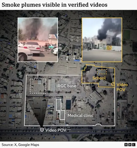
In one video a man films as he rushes into the school's courtyard which is located immediately to the north-east of the IRGC base. Part of a sign above the entrance is visible, which matches the first three letters of the word primary school in Persian.
From inside the school's courtyard, four plumes of black smoke can be seen, with two smaller ones pouring out of the windows of the top floor of the main school building.
Walls decorated with children's murals and letters of the Persian alphabet separate the school courtyard from the IRGC base.
Another clip filmed from a moving vehicle on the southern edge of the IRGC compound shows a sign marking the entrance. There are two visible IRGC logos on the entrances to the "Seyed al-Shohada educational and cultural corps" and a medical clinic, which Iranian media reports as belonging to the IRGC navy.
At least three columns of black smoke are visible in the footage: two closer to the entrance of the base, and a third further away behind the medical clinic.
The location of smoke plumes in verified videos correspond to where the damage is visible in satellite images.
Footage filmed later in the day showed significant damage to the school building. Emergency services search through the rubble while distressed families move slowly around the courtyard, some wailing.
One widely shared video geolocated to the school shows rescue teams at the scene finding a child's severed arm beneath the rubble. Schoolbooks and bloodied backpacks were also filmed among the debris.
What does satellite imagery show us?
Without access to more footage on the ground or eyewitness testimony, satellite imagery is crucial to our understanding of what happened.
Satellite imagery captured by Planet Labs on 4 March - four days after the incident - reveals more widespread destruction than previously confirmed in verified videos.
Several buildings in the area have been partially or fully destroyed and BBC Verify has identified at least five buildings with visible craters and black scorch marks - which indicates that there were several strikes.
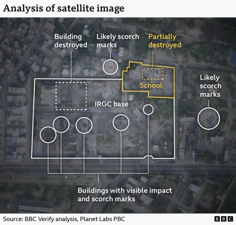
"So many [impact sites] so close together (relatively speaking) suggests there were one or more targets in close proximity to each other," said satellite image analyst Jamon Van den Hoek from Oregon State University.
"[It] seems it was intentional to hit the area," he said, adding "But we don't know what they intended to strike."
A senior analyst from McKenzie Intelligence Services told BBC Verify the crater on the ground floor of the two-story school building indicates that a specialised munition may have been used to "penetrate to the lower levels".
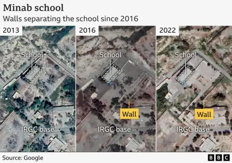
Is the school separate to the IRGC base?
The school building is located near the IRGC base.
Satellite imagery from 2013 appears to show the school building was part of the same compound, before a wall is seen in 2016 separating it.
Who is responsible for the attack?
Iran says the attack was carried out by the US and Israel. But neither Israel nor the US have claimed responsibility for damage to the school.
Israel has said it was "not aware" of any IDF operations in the area but told BBC Verify it is looking into the incident.
On Wednesday, US Defense Secretary Pete Hegseth told the BBC the US is still investigating the incident.
"We of course never target civilian targets, but we're we're taking a look at investigating that," he added.
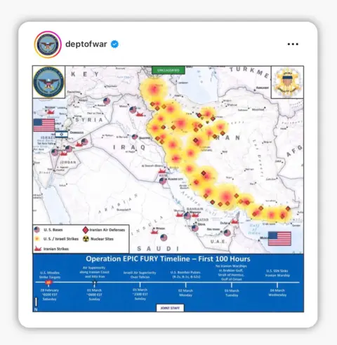
During the news conference, an illustrative map was shown of the "First 100 hours" of the US-Israeli war with Iran, marking the locations of strikes and Iranian air defences along the southern coast of Iran, which includes the area of Minab.
Without more footage of the remnants of munitions, it's not possible to clearly identify who is responsible.
A widely shared image posted on social media led to claims that the blast had been caused by a failed missile fired by the IRGC. However, we located the image to an unrelated incident in Zanjan, over a thousand kilometres away from Minab.
"It is unlikely that the significant blast damage seen here was caused by an Iranian surface-to-air missile, which carry relatively small explosive warheads," director of Armament Research Services, Jenzen Jones said.
Who was killed?
Iranian officials said most of the 168 people killed were children.
BBC Verify has not been able to independently verify those details through footage available of the incident. It's also not clear if any IRGC members were killed, or who may have been operating there.
The school itself had 264 pupils in total, according to Iran's Education Ministry.
A hand-written list published by Iranian media shows the names of 56 people reportedly killed in the incident, alongside their dates of birth. Forty-eight of these names are aged between six and 11.
BBC Verify has not been able to independently verify these details. However, at least three of the names on the list appear in another video where coffins are labelled with the same names.
Photos also show what appear to be three children inside body bags.
 Reuters
The US-based Human Rights News Agency (Hrana) has so far documented the deaths of 1,114 Iranian civilians since the beginning of the war, including 183 children.
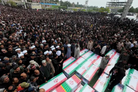
Days later, footage of thousands of people lining the streets for the funeral procession was broadcast by Iranian state media. Men can be seen carrying coffins - some child-sized - with the flag of the Islamic Republic draped over them. Crowds of women also held onto photos of boys and girls.
The semi-official Tasnim news agency, which is affiliated with the IRGC, published a photo and said 14 school teachers had been killed in the attack.
Additional reporting by Paul Brown.