Massive Alaska megatsunami was second largest ever recorded

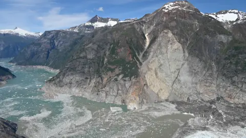 Photo by Cyrus Read/U.S. Geological Survey
A massive 'megatsunami' wave created when part of an Alaskan mountain crumbled into the sea is the second tallest ever recorded – and a reminder of the risks posed by melting glaciers, say scientists.
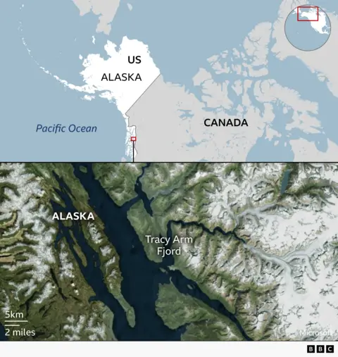
Last summer a giant wave swept through a remote fjord in southeast Alaska leaving destruction in its wake.
The event went largely unreported at the time, but a new scientific analysis shows it was caused by a massive landslide.
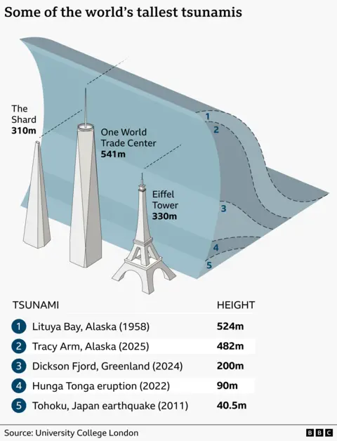
An incredible 64 million cubic metres of rock – the equivalent of 24 Great Pyramids - splashed into the water below. The sheer power of that amount of rock plunging into the fjord in under a minute created a gigantic wave almost 500 metres tall.
Only the time it happened – in the early hours of the morning – prevented tourist cruise ships being caught up in the devastation, say the researchers.
Dr Bretwood Higman, an Alaskan geologist, who saw for himself the damage at Tracy Arm Fjord, said it was "a close call".
"We know that there were people that were very nearly in the wrong place," he said. 'I'm quite terrified that we're not going to be so lucky in the future."
These huge waves, labelled megatsunamis, happen when a landslide caused by either an earthquake or loose rock hit water below. They are usually localised and dissipate quickly.
The other type of tsunamis happen in the open ocean and are directly triggered by earthquakes, or occasionally other powerful events such as underwater volcanoes.
They, like the 2011 Japan tsunami, can travel for thousands of miles, hitting populated areas and causing widespread devastation and loss of life.
The biggest megatsunami was in the 1950s and was over 500 metres. This latest megatsunami was the second largest.
Dr Higman arrived on the scene a few weeks after the tsunami hit at the Tracy Arm Fjord – a destination popular with cruise ships exploring the natural wonders of Alaska.
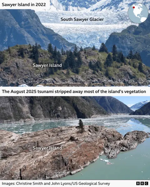
He found broken trees littering the mountainside and hurled into the water, and vast swathes of scarred rock stripped of soil and vegetation.
Alaska is especially vulnerable to megatsunamis because of its steep mountains, narrow fjords and frequent earthquakes.
Now new research published in Science suggests glacier melt driven by climate change is making such collapses far worse.
The team combined field work, seismic and satellite data to reconstruct a domino chain of events and trace the height of the wave.
Dr Stephen Hicks of University College London said the glacier was previously "helping to hold up this piece of rock", and so when the ice retreated, it exposed the bottom of the cliff face, "allowing that rock material to suddenly collapse into the fjord".
He and his colleagues have studied tsunamis for decades and are worried.
"More people are now going to remote areas - often these tourist cruises are going to see the natural beauty of the area to actually learn more about climate change - but they are also dangerous places to be."
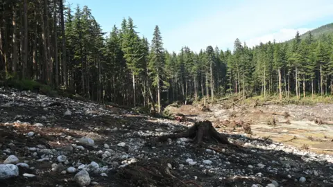 Photo by Cyrus Read/U.S. Geological Survey.
Dr Higman said there is little doubt that the risks of megatsunamis are increasing.
"At this point, I'm pretty confident that these are increasing not just a little bit, but increasing a lot," he said.
"Maybe in the order of 10 times as frequent as they were just a few decades ago."
The scientists are calling for wider monitoring of hazards in parts of Alaska that might be vulnerable to megatsunamis.
Some cruise companies have announced they are to stop sending ships into Tracy Arm amid safety fears.
