Use this page to see how the video clips map to the Geography objectives of the National Curriculum for England at Key Stages 1 and 2. The individual objectives are listed on the left, with the relevant BBC Teach content linked in the right hand column. The table also has broad relevance to the curriculum objectives of Scotland, Wales and Northern Ireland.
You can also download/print the objectives and content links using this pdf file.
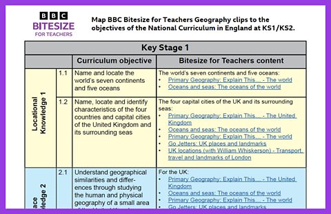
Key Stage 1
Pupils should develop knowledge about the world, the United Kingdom and their locality. They should understand basic subject-specific vocabulary relating to human and physical geography and begin to use geographical skills, including first-hand observation, to enhance their locational awareness.
Locational knowledge
- name and locate the world's seven continents and five oceans
The world's seven continents and five oceans:
Primary Geography: Explain This… - The world
Oceans and seas: The oceans of the world
- name, locate and identify characteristics of the four countries and capital cities of the United Kingdom and its surrounding seas
The four capital cities of the UK and its surrounding seas:
Primary Geography: Explain This… - The United Kingdom
Oceans and seas: The oceans of the world
Primary Geography: Explain This… - The world
Go Jetters: UK places and landmarks
UK locations (with William Whiskerson) - Transport, travel and landmarks of London
Place knowledge
- understand geographical similarities and differences through studying the human and physical geography of a small area of the United Kingdom, and of a small area in a contrasting non-European country
Human and physical geography
- identify seasonal and daily weather patterns in the United Kingdom and the location of hot and cold areas of the world in relation to the Equator and the North and South Poles
Identify seasonal and daily weather patterns in the UK:
The seasons - What are the seasons?
The seasons - What causes the seasons?
Primary Geography: Explain This… - The seasons
Primary Geography: Explain This… - Climate
Songs: Weather and seasons
The location of hot and cold areas of the world in relation to the Equator:
Primary Geography: Explain This… - The world
The seasons - Weather around the world
Summer and winter solstice
Pollution of the marine environment:
Oceans and seas - The plastic problem
Climate change:
The seasons - What are the seasons?
- use basic geographical vocabulary to refer to key physical features, including: beach, cliff, coast, forest, hill, mountain, sea, ocean, river, soil, valley, vegetation, season and weather
Beach, cliff, coast, sea, ocean:
UK locations (with William Whiskerson) - Life on the Isles of Scilly
UK locations (with William Whiskerson) - Fossil hunting along the Jurassic coast
Oceans and seas: The oceans of the world
Forest:
UK locations (with William Whiskerson) - A visit to the Caledonian Forest
Mountain:
UK locations (with William Whiskerson) - Mountains and electricity
River:
Primary Geography: Explain This… - Rivers
UK locations (with William Whiskerson) - Travelling on a canal boat
Season and weather:
The seasons - What are the seasons?
The seasons - What causes the seasons?
Primary Geography: Explain this… - Seasons
Primary Geography: Explain this… - Climate
- use basic geographical vocabulary to refer to key human features, including: city, town, village, factory, farm, house, office, port, harbour and shop
City, town, village, house:
Primary Geography: Explain This… - Cities, towns and villages
UK locations (with William Whiskerson) - Living in an eco-village
Farm:
UK locations (with William Whiskerson) - How our milk gets from the farm to the shop
UK locations (with William Whiskerson): Growing and picking orchard fruit
Port, harbour, shop:
UK locations (with William Whiskerson) - Life on the Isles of Scilly
UK locations (with William Whiskerson) - Jobs and tourism in a seaside town
Geographical skills and fieldwork
- use world maps, atlases and globes to identify the United Kingdom and its countries, as well as the countries, continents and oceans studied at this key stage
Use of maps:
Primary Geography: Explain This… - Maps
- use simple compass directions (North, South, East and West) and locational and directional language [for example, near and far; left and right], to describe the location of features and routes on a map
Points of the compass:
Primary Geography: Explain This… - Maps
Travel and transport - 1: Awesome animals
- use aerial photographs and plan perspectives to recognise landmarks and basic human and physical features; devise a simple map; and use and construct basic symbols in a key
Recognise landmarks and basic human and physical features:
Primary Geography: Explain This… - Maps
- use simple fieldwork and observational skills to study the geography of their school and its grounds and the key human and physical features of its surrounding environment.
Key Stage 2
Pupils should extend their knowledge and understanding beyond the local area to include the United Kingdom and Europe, North and South America. This will include the location and characteristics of a range of the world’s most significant human and physical features. They should develop their use of geographical knowledge, understanding and skills to enhance their locational and place knowledge.
Locational knowledge
- locate the world’s countries, using maps to focus on Europe (including the location of Russia) and North and South America, concentrating on their environmental regions, key physical and human characteristics, countries, and major cities
Use of maps:
Primary Geography: Explain This… - Maps
Europe:
A location in Europe
- name and locate counties and cities of the United Kingdom, geographical regions and their identifying human and physical characteristics, key topographical features (including hills, mountains, coasts and rivers), and land-use patterns; and understand how some of these aspects have changed over time
Counties, cities, regions of the UK:
Primary Geography: Explain This… - The United Kingdom
Coasts:
Exploring UK locations (Zoom In, Zoom Out) - Coasts and sustainable use of natural resources
Mountains:
Exploring UK locations (Zoom In, Zoom Out) - Mountains
Rivers:
Exploring UK locations (Zoom In, Zoom Out) - Rivers
Primary Geography: Explain This… - Rivers
Lakes, lochs, reservoirs:
Exploring UK locations (Zoom In, Zoom Out) - Lakes, lochs, reservoirs and the water cycle
Land use:
Changing land use (Settlements)
Exploring UK locations (Zoom In, Zoom Out) - Food, farming and agriculture
Exploring UK locations (Zoom In, Zoom Out) - Forests: deciduous and coniferous woodlands
Exploring UK locations (Zoom In, Zoom Out) - Peatlands, wetlands and the carbon cycle
- identify the position and significance of latitude, longitude, Equator, Northern Hemisphere, Southern Hemisphere, the Tropics of Cancer and Capricorn, Arctic and Antarctic Circle, the Prime/Greenwich Meridian and time zones (including day and night)
Equator, Northern Hemisphere, Southern Hemisphere, the Tropics:
Primary Geography: Explain This… - The world
Seasons: Weather around the world
Place knowledge
- understand geographical similarities and differences through the study of human and physical geography of a region of the United Kingdom, a region in a European country, and a region within North or South America
For regions of the UK:
Exploring UK locations (Zoom In, Zoom Out)
For regions of Europe (Germany and the Netherlands)
A location in Europe
Human and physical geography
- describe and understand key aspects of physical geography, including: climate zones, biomes and vegetation belts, rivers, mountains, volcanoes and earthquakes, and the water cycle
Climate zones, biomes and vegetation belts:
Biomes (Rainforests, Deserts, Savannahs, Tundras, Woodlands, Grasslands)
Rivers:
Exploring UK locations (Zoom In, Zoom Out) - Rivers
Mountains:
Exploring UK locations (Zoom In, Zoom Out) - Mountains
Earthquakes:
Primary Geography: Explain This… - Earthquakes
The water cycle:
Primary Geography: Explain This… - The water cycle
- describe and understand key aspects of human geography, including: types of settlement and land use, economic activity including trade links, and the distribution of natural resources including energy, food, minerals and water
Types of settlement:
Settlements (Village, Town, City, Holiday resort)
Primary Geography: Explain This… - Cities, town and villages
Exploring UK locations (Zoom In, Zoom Out) - UK settlements and navigating using maps
Exploring UK locations (Zoom In, Zoom Out) - Urban settlements: living in a city or megacity
Land use:
Changing land use (Settlements)
Exploring UK locations (Zoom In, Zoom Out) - Food, farming and agriculture
Economic activity:
Exploring UK locations (Zoom In, Zoom Out) - Food, farming and agriculture
Exploring UK locations (Zoom In, Zoom Out) - Tourism
Energy:
Exploring UK locations (Zoom In, Zoom Out) - Coasts and sustainable use of natural resources
Food:
Exploring UK locations (Zoom In, Zoom Out) - Food, farming and agriculture
Water/Hydrology:
Exploring UK locations (Zoom In, Zoom Out) - Rivers
Exploring UK locations (Zoom In, Zoom Out) - Lakes, lochs, reservoirs and the water cycle
Marine pollution/Sustainability/Conservation:
Exploring UK locations (Zoom In, Zoom Out) - Ocean life
Exploring UK locations (Zoom In, Zoom Out) - Peatlands, wetlands and the carbon cycle
Geographical skills and fieldwork
- use maps, atlases, globes and digital/computer mapping to locate countries and describe features studied
- use the eight points of a compass, four and six-figure grid references, symbols and key (including the use of Ordnance Survey maps) to build their knowledge of the United Kingdom and the wider world
- use fieldwork to observe, measure, record and present the human and physical features in the local area using a range of methods, including sketch maps, plans and graphs, and digital technologies
