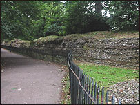
When you reach what remains of the London Gate and Roman Wall, you are standing at what was the eastern end of the Roman City of Verulamium, one of the most important cities in the Roman Empire and the third largest city in Roman Britain with the biggest basilica this side of the Alps! Where you are standing was where the road from London, called Watling Street, entered the city through an enormous triumphal arch. The Roman town was first laid out in AD 49 but the walls weren't built until between AD260 and 265, hence Boudicca's army found it very easy to raze it to the ground in AD61. Here you can see the remaining foundations for a very large gateway and also the largest part of the old Roman Wall that remains. The gate would have consisted of two very large drum towers, two archways for vehicles and troops and then two smaller ones where people could walk through without being mown down by a chariot! The wall would have been about 3m wide and 5m high. There is some controversy over the dating of the wall but you can see that it's made up of layers of red Roman bricks with about a metre of flint between these brick layers. The gate would have been made of the same and the whole thing would have been plastered or rendered in some way. Flint
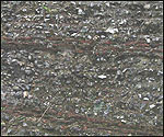
Flint was an obvious choice for the Romans to build their wall with because it just comes out of the ground in this area and it is extremely durable. You can also see it in many other buildings in the city. The flint was formed around the same time as the chalk. As well as the chalk-forming algae, there were also animals composed of silica living in the sea. After they were buried in the chalk sediment, the silica was re-dissolved then re-formed as flint. Sadly, most of the wall is now gone because the old Roman city has been plundered over the centuries for building stone. A lot of churches and older houses in the city have a facing of flint because it's hard and persistent and resists weathering. This is also why it accumulated along this river valley. It was able to resist the abrasion from the river while finer material was washed away. The Romans probably didn't even need to quarry it as there would've been so much lying around on the surface. But the bricks would have been made fairly locally, somewhere like Hockliffe or Little Brickhill where there was proper brick earth. Brickmaking was a very big industry in the Roman period. So why was Verulamium built here?
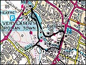
Well, the river is important, both as a resource and as a defence, but if you look in front of you, although it's quite difficult to see because of the trees, try to imagine the whole area stripped bare of vegetation. The hill goes up on the northern side of the valley, and from the top you can see for miles. The city may be in a fairly flat valley but it's in a very commanding position with a very good vantage point, particularly on that northern side. If anyone was going to attack, the residents would have had good warning. As such, the lay of this land has always helped to make it an important area for human settlement and could have contributed to its original name. Settlement in the area really began to get going during the late Iron Age in the first century BC. There were iron age settlements around what is now Verulamium and there's also one at Prae Wood. The major settlement was known as Verlamion and was founded by a Belgic tribe called Catuvellauni. It was their capital for some time before they moved to Colchester. The area inhabited by this tribe was on raised ground to the south west of the river where the King Harry Estate now stands. This location accounts for the name of the town which could mean 'Above the Pool'. The River Ver was named later. After southern Britain had fallen to the Romans in AD 43, a fort was built near where St Michael's Church now stands to the north east of the Verlamion. The Roman style town of Verulamium wad laid out six years later. In the trees here you may well see a grey squirrel today, but you wouldn't have in Roman times. You may possibly have had beavers, definitely wolves and further north you could well have had European brown bears. It was a fairly wild area. A Roman knows!
Behind the Gate you can see a ditch. This is not a natural part of the landscape but a typical Roman defensive ditch. In the winter, when there is less greenery, you can see it has an unusual profile. If you look at an iron age ditch you can see it's like a sharp 'U' shape, but if you look at a Roman ditch the sides aren't symmetrical. The side furthest away from the wall is steeper than the side coming up towards the wall and it is thought that this is the Romans being rather clever. Imagine if you're trying to attack the town. You can zoom down the steep side into the ditch and then have what looks like an easy run up to the walls! But then the Romans throw everything they've got at you and you find you can't get up to them. So you then turn to run away and the slope is so steep that it's difficult to get back up. They just pick you off as you try to get away. In fact the area in front of the wall is a maximum firing range from the top of the wall - it's all very cleverly worked out! You can now take the time to walk up along the length of this part of the wall, or turn and walk back down towards the lake. Walk along the length of the wall >> |