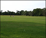
On this part of the walk you can either keep to the concrete path or walk on the flood plain grass itself - an area that is widely used by the public. This area is the flood plain of the River Ver, but although it's difficult to imagine, the river used to flow right through where you are walking. Up until a few hundred years ago, it was much wider and probably shallower as well, but since that time, humans have dug it into deeper ditches and moved it for industrial use to work their water mills. It is thought that the first human impact was by the Romans, just under 2,000 years ago, who moved the river to use it as a mill stream for what is now the Abbey Mills, which you will see later on the walk. Before that it was a bit of a swamp. Currently it's pushed right over into the far corner of the valley floor. If you stand and face the Abbey, it runs in a channel where the trees start and the grass finishes. You can walk across to see it, but there will be other chances to do this further on in the walk. The underlying rock where you are walking is chalk and the River Ver is what is known as a chalk stream. It rises north of Redbourn at Kensworth Lynch and joins the River Colne at Bricket Wood. Chalk Streams are shallow with gravel beds and clear water and are fed from groundwater which is stored in the layers of chalk underneath which soak up water like a sponge. At various points the water emerges in the form of springs which feed the river. The Ver, like other chalk streams, has a porus bed which means that water filters through it and it needs a high water table to exist. The Ver relies on winter rain percolating through to the chalk below the Chiltern Hills, but below average rainfall in winter greatly reduces this recharge. With levels being so low, even heavy rain the following summer will not replenish underground reserves. What is chalk?
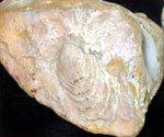
The chalk lying beneath your feet, can be dated back 80-100 million years when the whole of north west Europe was beneath the sea, and was created by the algae living in the ocean. The chalk is composed of little plates formed from the algae, which are known as coccoliths. These are very pure calcium carbonate, which the algae extract from the sea water that are then secreted as white calcium carbonate. So, around 90 million years ago, the area where the city of St Albans now sits was, like most of southern Britain, under the sea. But between that time and around 2 million years ago, not much is known about what happened as there is not much evidence in the form of deposits. What is known is that the chalk has been here far longer than the Ver. But this is not the only river that has run through this area. It is the legacy left by a far more famous river and maybe, if it wasn't for the ice age, St Albans may well have been England's capital city! An alternative capital
Between 2,000,000 and 450,000 years ago, the River Thames ran through the vale of St Albans, which is the broad open valley between the hill that St Albans sits on and several miles to the south where you now find Radlett and Shenley. i.e. where you are now walking! Where the Thames flowed it formed a series of little gravel terraces, because under the cold conditions of the time, the river was able to transport flints, coarse cobbles and boulders. This is why this valley floor is still covered with a thin layer of flints, clays and silts. The much finer material was carried out to sea - which at that time meant somewhere off the East Anglian coast, as far up as southern Norfolk!  | If the Thames hadn't moved, could St Albans have been England's capital city? |
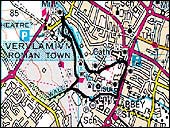
The Thames' modern course through London is a diversion, brought about by glaciation during the Ice Age. The ice covered most of East Anglia, and the tongue of it came up this old Thames valley just about as far as St Albans. The limit of the ice is actually marked by a line within 100 metres of the M1 in the Bricket Wood area. But it is pure coincidence that Britain's first motorway was built along this line! The ice blocked the valley and as a result, the water that couldn't flow through it created a large lake to the south and west of St Albans. This overflowed, creating channels that went from little valley to little valley as you go eastwards. The new course caused by the lake's overflow created a new route for the Thames which is the one that we now know. The River Ver was therefore originally a tributary of the old Thames, running down a valley from the north of it, to the south east. The Ver runs in a south-easterly direction because the underlying rock slopes gently down to the south east. The main rock stratum is chalk, which forms the Chiltern Hills in the north. This rock then goes underneath London, which is a big basin, and comes up again south of our capital city to form the north downs. The River Ver starts in the Chilterns, and runs through Verulamium Park, and on to the east of St Albans when it suddenly makes a sharp angular bend to the south. This is because half a million years ago the ice blocked its exit and the river was forced to flow along the margin of the ice. That course has been retained today. The flood plain you are now on does occasionally flood, especially if there is a big storm. But the amount of water coming down the river is fairly strictly controlled, partly by the fact that higher up the Ver, pumping stations take water from the chalk which prevents too much water getting into the river.
|