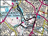
To your right you can see the Abbey on the hill. There's quite a steep slope leading up away from the flood plain to the Abbey and the rest of the city, although it's quite hard to see this through the trees. But behind you and to your left, there's a much gentler slope on the southern side of the valley. Why?
The reason for this is that most of the shaping of the valley occurred under very cold conditions, during the Pleistocene period. This period dates back from about one to two million years ago, although the last really cold period was just before around 10,000 years ago. But that had lasted for at least 20,000 years and had occurred on and off for around 100,000 years! And if that kind of timescale makes your head spin - let's just say it was a very long time ago! Under these cold conditions, there were freezing temperatures throughout the winter but it was often quite warm in the summer, although not as warm as it gets now. The ground would freeze to a depth of 50 or 100m so the whole of the upper part of the chalk would be frozen and therefore become impermeable by water. Erosion
Nowadays, when rain falls, it percolates into the ground and falls into the ground water within the chalk. But under these cold conditions, the water couldn't get into the ground, so it ran over the ice instead and created valleys like this one by erosion. And under these conditions, the northern slopes, which face south or south west, like the one that the Abbey sits at the top of, get more sunshine than the southern sides of the valley facing north or north east, like the one behind you. When the sun hit the ice, the permafrost layer would melt and sludge down the valley because it becomes saturated. And because it sees more sunshine, this process occurs much more strongly on the north side of the valley making it less stable. A lot of ground material would also be carried down the slope with the melt water and as it did so it would tend to undercut the less stable northern slope and transport soil down the slope. But the southern slopes would tend to remain stable and would be covered by a soil layer that wasn't transported anywhere as rapidly. So, under these conditions you develop an asymmetry of the valley, with the southern slope being rather less steep than the northern slope going up to the abbey. You can see also see this on Holywell Hill (Stage 11) which is a much steeper slope than St Stephen's Hill on the south side of the valley, that Holywell Hill runs into. |