Use this table to see how the video clips from BBC Bitesize for Teachers map to the Geography objectives of the National Curriculum for England at Key Stage 3. The individual objectives are listed on the left, with the relevant BBC content linked in the right hand column. The table also has broad relevance to the curriculum objectives of Scotland, Wales and Northern Ireland.
You can also download/print the objectives and content links using this pdf file.
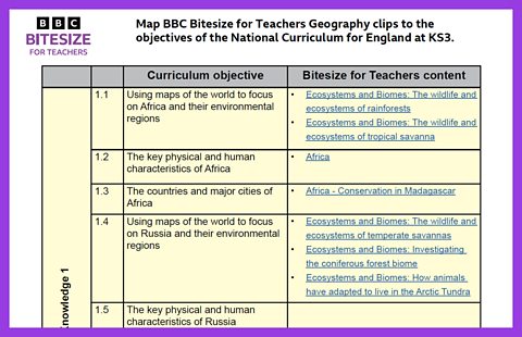
Locational Knowledge 1
1.1 Using maps of the world to focus on Africa and its environmental regions
1.2 The key physical and human characteristics of Africa
1.3 The countries and major cities of Africa
1.4 Using maps of the world to focus on Russia and its environmental regions
1.5 The key physical and human characteristics of Russia
1.6 The major cities of Russia
1.7 Using maps of the world to focus on Asia - including China and India - and their environmental regions
1.8 The key physical and human characteristics of Asia
1.9 The countries and major cities of Asia
1.10 Using maps of the world to focus on the Middle East and its environmental regions
1.11 The key physical and human characteristics of the Middle East
1.12 The countries and major cities of the Middle East
Place Knowledge 2
2.1 Understand geographical similarities, differences and links between places through the study of a region within Africa
2.2 Understand geographical similarities, differences and links between places through the study of a region within Asia
Physical Geography 3
3.1 Geographical timescales and plate tectonics
- Secondary Geography: Explain This… - Plate tectonics
- Plate tectonics: Earthquakes, volcanoes and tsunamis
- Physical Geography with Liz Bonnin: How has glaciation shaped the landforms of the Northern Hemisphere?
- Physical Geography with Liz Bonnin: How can plate tectonics impact oceans?
- Physical Geography with Liz Bonnin: Plate tectonics in the UK - Anglesey
3.2 Rocks, weathering, and soils
- Secondary Geography: Explain This… - Erosion
- Physical Geography with Liz Bonnin: The erosion of the Grand Canyon
- Physical Geography with Liz Bonnin: The geology of the Jurassic Coast
- Physical Geography with Liz Bonnin: How has glaciation shaped the landforms of the Northern hemisphere?
- Rock Types at Great Heights
3.3 Weather and climate
3.4 Change in climate from the ice age to the present
3.5 Glaciation
- Secondary Geography: Explain This… - Glaciation
- Physical Geography with Liz Bonnin: How have physical processes impacted the landscape of Yorkshire?
- Physical Geography with Liz Bonnin: Glaciation and the UK coastline
- Physical Geography with Liz Bonnin: How has glaciation shaped the landforms of the Northern hemisphere?
3.6 Hydrology
- Secondary Geography: Explain This… - River flooding
- Secondary Geography: Explain This… - Responses to flooding
- Physical Geography with Liz Bonnin: What is the water cycle?
- Physical Geography with Liz Bonnin: How does a river change as it travels downstream?
- Physical Geography with Liz Bonnin: The impact of flooding in the UK
- Seriously Raleigh: Expedition to Guyana: Rivers and waterfalls
- Exploring India: The Ganges
- UK river case studies
3.7 Coasts
- Explain This… Coastal flooding
- Explain This… Responses to flooding
- UK Geography - The Big Issues: Coastal erosion
- Physical Geography with Liz Bonnin: What coastal management techniques are being used on Hayling Island?
- Physical Geography with Liz Bonnin: What is a spit and how does it form through longshore drift?
- Physical Geography with Liz Bonnin: The geology of the Jurassic Coast
- Physical Geography with Liz Bonnin: Glaciation and the UK coastline
Human Geography 4
4.1 Population and urbanisation
4.2 International development
4.3 Economic activity in the primary, secondary, tertiary and quaternary sectors
4.4 The use of natural resources
Physical and Human Geography 5
5.1 How human and physical processes interact to influence and to change landscapes
5.2 How human and physical processes interact to influence and to change environments and the climate
5.3 How human activity relies on effective functioning of natural systems
Geographical Skills and Fieldwork 6
6.1 Build on the knowledge of globes, maps and atlases and apply and develop this knowledge routinely in the classroom and the field
6.2 Interpret Ordnance Survey maps in the classroom and the field using grid references and scale
6.3 Use topological and other thematic mapping
6.4 Use aerial and satellite photographs
6.5 Use GIS to view, analyse and interpret places and data
6.6 Use fieldwork in contrasting locations to collect, analyse and draw conclusions from geographical data
6.7 Use multiple sources of increasingly complex information
