De-Graft visits Mount Snowdon (Yr Wyddfa) - tallest summit in Wales - to consider how mountains are created by tectonic plate movement and volcanoes.
De-Graft: I’m in Wales, finding out about the country’s tallest mountain - Snowdon. It takes a good few hours to walk up and down it. But thankfully there’s a train you can catch too.
Mountains are high areas, rising more than 600 metres from the surrounding land. And often they’re found in groups called mountain ranges. This is Snowdon. The summit, or top of the mountain, is over 1000m high and it’s part of a mountain range called Snowdonia. Later locals Iola and Oliver are going to be helping me think about climbing mountains and how you can prepare.
But first, let’s zoom out. Snowdon is here in North Wales. The highest mountain in the UK is actually in Scotland and it’s called Ben Nevis. Slieve Donard is the highest in Northern Ireland. And Scafell Pike is the highest mountain in England.
Mount Everest is perhaps the most well-known mountain in the world. It has the highest peak above sea level at 8,848 meters. Mount Everest is part of the Himalayan mountain range in Asia where many of the world’s tallest mountains are found. Earth’s surface is made up of different sections called tectonic plates. Most mountains are fold mountains, which means they’re created when two tectonic plates collide, and they force the ground up where they meet. Like this…
Other mountains are created by ancient volcanoes. These are often individual peaks. Ben Nevis in Scotland and Snowdon here in Wales were once very large active volcanoes. They last erupted millions of years ago. Another cool thing about mountains is that they can affect the weather as clouds carrying water droplets are pushed up and over the physical barrier of the peak, they move into colder air, lose their energy and then drop their load as precipitation: rain, hail, snow or sleet.
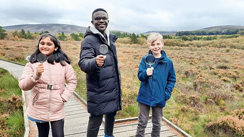
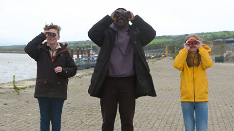
I’m meeting Oliver and Iola at the bottom, or base, of Snowdon. We’re packing backpacks to prepare for a hike.
What kind of things do you have in your backpack?
Child: I have an emergency survival kit. First off, we have a whistle, to make sure that people know where you are and if someone is in danger.
Child: If you go up the mountain and you get really thirsty, you’re going to need a drink. If you don’t drink, sometimes you can get a bit tired, so it’s good to always stay hydrated.
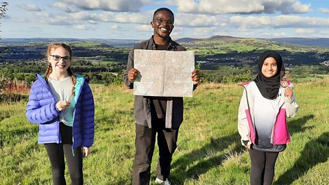
De-Graft: Nice. So, we’ve got a map here. Do you guys know what the numbers and lines mean?
Child: The numbers means how high up the mountain is.
Child: The more where there's loads of orange lines together, it means that it would be steeper to climb up.
De-Graft: Yeah, you guys are pretty much there. We call that contours. The closer the lines are to each other, the steeper the hill or the mountain is. The further away they are, the more gentle the slope is. Now we can use contours to help us prepare for a route when we’re hiking, to decide whether we want to hike on a steeper route or a more gentle slope.
What do you think the weather is like at the top of a mountain?
Child: I think it would be quite windy and snowy.
De-Graft: Yeah, you’re right. Did you know that on tall mountains, like Mount Everest, it’s so high up that people need oxygen masks to help them breath, because the higher up you go the thinner the air gets.
OK, time to compare… Snowdon is the same height as around 240 double decker buses stacked on top of each other! Mont Blanc, one of the tallest mountains in the alps in Europe, is 4807 metres, over a thousand double deckers tall.
So, is there a hill or mountain near you that you could explore? Why not try and find it on a map? Zoom in and have a look for yourself.
Right, off you go then, guys. But, just double checking, there is a train we can get, right? No?
Video summary
Download/print a transcript of the video.
De-Graft visit Snowdon, the tallest mountain in Wales, to explore what a mountain is and how they’re formed by tectonic plate movement.
Mountains typically rise more than 600 metres from the surrounding land and often form mountain ranges. Most mountains are fold mountains - created when two tectonic plates collide and force the ground up. Other mountains are created as individual peaks by ancient volcanoes.
De-Graft joins two local children to explore the contour lines of a map and what they reveal.
NB: In November 2022 Snowdonia National Park was formally renamed 'Eryri' using the Welsh language. The Welsh for 'Snowdon' is 'Yr Wyddfa' - pronounced 'Ur With-fa'.
Teacher Notes
Download/print the Teacher Notes for this episode (pdf).
Teacher Notes prepared in partnership with the Geographical Association.
Questions to consider:
- What is a mountain?
- How do mountains form? How do they change over time?
- Have you ever seen or climbed a mountain? What was the weather like? What did it look like?
- What challenges do mountain environments present?
- How do mountains in the UK compare to other mountains across the globe?
- How are mountains part of the water cycle? What happens to the climate as you climb a mountain?
- What are contour lines and how can they be useful?
- If you were going to climb a mountain how would you prepare?
- What do you think could be some of the dangers involved in climbing a mountain?
Suggested activities to further explore learning:
1. Cardboard contours
This activity will help pupils learn how hills and valleys are represented on OS maps, through the use of contour lines.
- Give pupils in small groups a different OS map or printout of a map with a mountain/hill on it, represented by contour lines
- In their groups, ask pupils to draw out each contour on individual bits of cardboard, cutting them out and stacking them on top of each other to make a 3D model of a mountain. When you look down on the cardboard model from above it should look like the 2D contour drawing of the hill/mountain on the original map.
2. Mini mountain hike
Pupils could build a mountain range with soil in the school grounds and use a toy figure to explore. You could create a stop motion video of your character overcoming the various challenges they find on the mountainside, including: cliffs, rivers, dense forest and exposure to the weather. Add in narration and sound effects to make it realistic.
Think about:
- What your character would have in their bag.
- Are there alternative routes that they could take to reach the highest point, or summit?
- Would your character do this alone or would it be safer to be in a group?
Key terminology:
Ascend – to climb up a mountain.
Base – the bottom of a mountain.
Contours – lines on a map with numbers alongside that show the height of the land. The closer the lines are to each other, the steeper the hill or the mountain is.
Descend – to climb down a mountain.
Erosion – when water wears away at land.
Elevation – the height of an area of land compared to a reference point, normally the average sea level.
Fold mountain – Most mountains are fold mountains, which means they’re created when two tectonic plates collide and they force the ground up where they meet.
Peak – the top or summit of a hill or mountain.
Tectonic plates – Earth’s surface is made up of different sections which are called tectonic plates. The plates are constantly moving and volcanoes and mountains can be found at plate boundaries.
Valley – a long area of lower land, often between hills and created by rivers.
Volcano – typically a cone-shaped mountain that has been erupted from the Earth’s crust, often having a crater.
Suitable for teaching geography at KS2 in England and Northern Ireland, Progression Step 3 in Wales and 2nd level in Scotland.
Food, farming and agriculture. video
Exploring farming and agriculture - a key UK industry. Includes arable, pastoral and mixed farming and examples of rural and urban farms.
UK settlements and navigating using maps. video
Exploring the different types of settlement in the UK - including villages, towns and cities - and how to navigate using maps, including symbols, compass points and co-ordinates.
Urban settlements - living in a city or megacity. video
Exploring key aspects of cities and megacities - building use, population density, environmental impact and sustainable choices.
Coasts and sustainable use of natural resources. video
Examining a coastal region of North Wales, including a local wind farm and examples of the sustainable use of natural resources.
Rivers - the course of a river from source to mouth. video
Exploring the key aspects of rivers - the source, tributaries, streams, meanders, ox-bow lakes, river mouth and estuary.
Lakes, lochs, reservoirs and the water cycle. video
Visiting Lake Windermere to consider lakes, lochs and reservoirs and their place in the water cycle.
Forests - deciduous and coniferous woodland and biodivsity. video
Exploring a forest region in the Lake District to discover the rich biodiversity of woodland habitats.
Shore, coast and ocean. video
Visiting a marine reserve in Scotland to discover the biodiverse habitat it offers, but also the importance of conservation.
Peatlands, wetlands and the carbon cycle. video
Exploring the significance of peatland and wetland habitats to store water and absorb carbon or CO2.