
It's hard to be believe that we were all sitting in the garden and doing outdoor activities over the weekend. Then we get up to start the working week and it's wet and cold! However, the week ahead is promising. Monday will probably be the wettest day with some sunshine to look forward to.
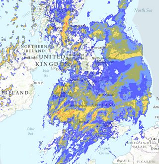
Met Office Radar Chart - 10am Mon 18th May 2015
Here is the radar picture on Monday 10am. Can you make out where Wales is? There's so much blue and green on top of the map. By Monday afternoon much of that rain will clear into England. Then we'll have some sunshine with the risk of a few showers. Much of the showers will be in the north and west, spreading across the country through Monday night. I can't rule out the odd rumble of thunder.
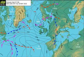
Met Office Pressure Chart - Tues 19th May 2015
The pressure chart for Tuesday is showing a trough which is the black line you can see on the map. That will bring some intense showers and we could see some hail and thunder. Brisk north-westerly winds will take the edge off the temperatures which will range between 11-13°C. On the plus side, there will be some sunshine in between the showers.
Wednesday will start on a chilly note with sunshine and showers. It will become drier for the afternoon. Thursday looks like the driest day with some sunshine at first, but turning cloudier through the day. Friday will have thicker cloud and patchy rain spreading south-eastwards throughout the day.
The bank holiday weekend is not a total wash out. It will be mostly dry on Saturday and Sunday. There is a risk of rain later on Sunday into bank holiday Monday. So please keep an eye on the forecast because the most accurate forecast is up to five days, but I just wanted to give you a rough idea.
Have a fab week and I leave you with this spectacular picture.