
There's a lot of weather heading our way this week; heavy rain, showers and gusty winds! It’s a huge difference to last week of course which was dominated by high pressure which brought dry, bright and settled conditions.
However for Monday, low pressure has brought some heavy rain and showers. On Monday afternoon strong winds in the Bristol Channel and the far south and south-east of Wales will see gusts of 45 to 50mph. Monday night will see further rain and showers, which will be heavy in places with some drier, clearer spells later in the night.
Tuesday promises to be a better day; there will be drier and brighter moments with scattered showers and some sunny spells. The wind will be lighter than on Monday, so it should feel a little warmer too, with highs between 14 and 17°C.
During Wednesday into Thursday, the weather is set to go downhill with a deepening area of low pressure moving in from the Atlantic and tracking north-east across England and Wales.
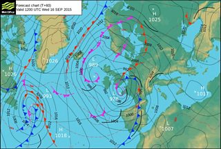
Met office weather chart for Wednesday 16 September
This low will contain very moist air from the remnants of tropical storm Henri so some heavy rain and showers are likely, together with a risk of strong to gale force winds. 15 to 30mm of rain is expected to fall, possibly double this in a few places causing some poor travelling conditions.
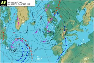
Met Office weather chart for Thursday 17 September
On Friday cool north-westerly winds will bring a mixture of sunshine and blustery showers. However, the wind will gradually ease with a dry and calmer end to the day.
At the moment, Saturday looks to be dry thanks to a ridge of high pressure with mist and fog patches lifting and leaving some sunshine. The wind should be light with temperatures rising to around average after a cool start.
