
Yorkshire at risk from renewed flooding
Heavy rainfall in the next 30 hours could lead to yet more flooding across parts of Yorkshire. Current indications suggest some Pennine catchments of North & West Yorkshire could be most at risk.
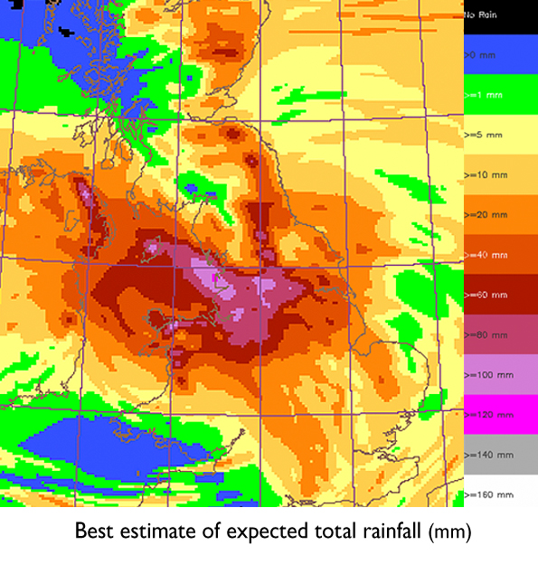
The very active weather system which I wrote about here on Friday and is currently affecting much of our region could produce 50-75mm in total in some parts of Yorkshire - with around 100mm possible in one or two exposed Pennine spots, see diagram below.
There are several reasons why such high rainfall totals are expected.
Firstly, some of the air is of tropical origin, having been drawn from ex-hurricane Nadine as it formed late last week; secondly, the weather front bringing the rain will become slow moving across the North of England, leading to a long period of rainfall; thirdly, air is being pushed up over the Pennines by a strong Northeasterly wind at first, enhancing rainfall, hence some of the largest totals will be across the eastern upslopes of the hills.
With the water table and soil moisture levels higher than average especially in western areas following the wet spring and summer, which you can read more about here, flooding is a distinct possibility as we head through tonight and tomorrow, as the region's rivers take the strain once again.
Folow me on twitter @Hudsonweather
 Hello, I’m Paul Hudson, weather presenter and climate correspondent for BBC Look North in Yorkshire and Lincolnshire. I've been interested in the weather and climate for as long as I can remember, and worked as a forecaster with the Met Office for more than ten years locally and at the international unit before joining the BBC in October 2007. Here I divide my time between forecasting and reporting on stories about climate change and its implications for people's everyday lives.
Comment number 1.
At 17:22 24th Sep 2012, Tim wrote:I have been a little sad and put a big bucket outside and in Sheffield S25 we have had 50mm's of rain by 17:21. If anything the bucket hasn't captured all the rain as it is 2 ft high.
Complain about this comment (Comment number 1)
Comment number 2.
At 17:26 24th Sep 2012, millennia wrote:Wettest drought in history continues unabated, damn that CO2! I suppose now we're going to get the coldest warmest winter ever as well.
Complain about this comment (Comment number 2)
Comment number 3.
At 17:51 24th Sep 2012, E Gouthwaite wrote:Noticed at weekend many potatoe crops have been underwater in low areas throughout the Summer period so this lot will not help.
Complain about this comment (Comment number 3)
Comment number 4.
At 18:08 24th Sep 2012, Tim wrote:When I gave a 50 mm measurement, it was by a guess from how high it looked, but when I used a metal rule it was 75 mm.
Complain about this comment (Comment number 4)
Comment number 5.
At 19:00 24th Sep 2012, QuaesoVeritas wrote:#1. - Tim wrote:
"I have been a little sad and put a big bucket outside and in Sheffield S25 we have had 50mm's of rain by 17:21. If anything the bucket hasn't captured all the rain as it is 2 ft high."
Do you mean that the bucket is 2 foot tall?
It sounds like a big bucket, but that shouldn't make much difference to the accuracy of the measurement.
If the diameter is the same all the way up, it should be fairly accurate, but if it is narrower at the bottom, it would over-state the amount.
You could probably do a calculation to correct it.
Apparently in the 1700's they used to measure rain by weight, but you would have to know the diameter of the container to make any sense of that.
Complain about this comment (Comment number 5)
Comment number 6.
At 12:58 25th Sep 2012, QuaesoVeritas wrote:Peter Gibbs was on the BBC News Channel last night saying that the wind in the NE of England was going to increase overnight, while the actual chart clearly showed that the wind was going to decline, with very little wind this morning.
Sure enough, the wind declined overnight and it was virtually calm between 09:00 and 11:00.
Wind is picking up again now, but nowhere near as strong as forecast on the MO website.
The problem is that when the weather doesn't perform to forecast, that causes a loss of confidence in the accuracy of subsequent forecasts, even though they may turn out to be correct.
Complain about this comment (Comment number 6)
Comment number 7.
At 13:05 25th Sep 2012, ukpahonta wrote:They are always correct:
https://www.metoffice.gov.uk/about-us/who/how/case-studies
Complain about this comment (Comment number 7)
Comment number 8.
At 14:59 25th Sep 2012, QuaesoVeritas wrote:#7. - ukpahonta wrote:
"They are always correct:"
You mean they only report on things they are correct on!
The worst of the rain seems to have fallen in the north of the region.
Do we know if there has been much flooding in Yorkshire?
Complain about this comment (Comment number 8)
Comment number 9.
At 15:25 25th Sep 2012, greensand wrote:@8 QV wrote:
"Do we know if there has been much flooding in Yorkshire?"
Take a look at:-
https://www.environment-agency.gov.uk/homeandleisure/floods/riverlevels/120699.aspx
Click on the "hotspots"
River Aire at Knottingley Lock (Pontefract) is very high.
You can check across the country
Complain about this comment (Comment number 9)
Comment number 10.
At 16:10 25th Sep 2012, ukpahonta wrote:#8 QV
History belongs to those that write it:
'The World Meteorological Organization compares similar statistics among national met. services around the world. These show that the Met Office is consistently one of the top two operational services in the world.'
https://www.metoffice.gov.uk/about-us/who/accuracy/forecasts
Complain about this comment (Comment number 10)
Comment number 11.
At 17:09 25th Sep 2012, QuaesoVeritas wrote:#10. - ukpahonta wrote:
"History belongs to those that write it:"
Thanks for that.
Do you know if this monitoring is relatively new?
When I checked about a year ago, they didn't seem to do anything as detailed as that.
Some of the figures suggest high accuracy, but it would be interesting to compare that with how accurate it would be just to put out forecasts based on say "normal" temperature figures. My guess is that the percentage within 2c of the actual would be pretty high.
They also say:
"It is difficult to forecast rainfall at a pinpoint location, therefore the target for this element is not as high as for others. For example, one location may have rain and a location a mile away may remain dry."
But the point is that they claim to be able to forecast for specific locations, in fact they brag about the fact that the 5 day forecasts are for about 5000 locations, not the 45 they measure.
Also, I don't know exactly what they mean when they refer to a 12 month moving average.
Complain about this comment (Comment number 11)
Comment number 12.
At 17:19 25th Sep 2012, QuaesoVeritas wrote:'#9. - greensand wrote:
"River Aire at Knottingley Lock (Pontefract) is very high."
Thanks, that will be useful.
True, the river at that location is near to the highest recorded but while the others I looked at seemed to be above average, they were no where near the highest recorded.
However, that doesn't mean there is no flood risk.
I couldn't find a hotspot for Morpeth, where there has been flooding, although the nearby one at Mitford is within the "flooding is possible" range.
Complain about this comment (Comment number 12)
Comment number 13.
At 18:07 25th Sep 2012, PingoSan wrote:So it wasn't the Met Office that told us all to plant drought-resistant species for our Mediterranean climate?
Complain about this comment (Comment number 13)
Comment number 14.
At 19:05 25th Sep 2012, hegaldi wrote:Paul and other contributors - have you seen the video just published on the web site https://www.artificialclouds.com?
Complain about this comment (Comment number 14)
Comment number 15.
At 20:22 25th Sep 2012, ukpahonta wrote:#11 QV
Previously:
For each forecast (fc) and corresponding observation (ob), a score is awarded to the following criteria:
For the first maximum and minimum temperatures
0 {less than or equal to} |fc-ob| {less than or equal} to 1°C score 1 point
1°C {less than} |fc-ob| score 0 points
And the second maximum and minimum temperatures
0 {less than or equal to} |fc-ob| {less than or equal to} 2°C score 1 point
2°C {less than} |fc-ob| score 0 points
The percentage correct (PC) is defined as: PC = (100 x score)/(max score), where score is the total points scored during the period and max score is the maximum points possible in the period.
https://www.metoffice.gov.uk/research/weather/numerical-modelling/verification/uk-temperature-doc
With results up to March 2011:
https://www.metoffice.gov.uk/research/weather/numerical-modelling/verification/uk-temperature
And now:
The early morning forecast on our website is used to produce a percentage number of the times when the forecast is accurate to within +/- 2°C.
Previously +/- 1°C on first day and +/- 2°C on second day
Now +/- 2°C on both days.
Also this is new:
94% of three hourly temperatures are accurate to within +/- 2°C on the current day (12-month average).
The question is do they get a target related bonus, hee,hee ?
Complain about this comment (Comment number 15)
Comment number 16.
At 20:14 29th Sep 2012, QuaesoVeritas wrote:"With the water table and soil moisture levels higher than average especially in western areas following the wet spring and summer, which you can read more about here, flooding is a distinct possibility as we head through tonight and tomorrow, as the region's rivers take the strain once again."
Normally highly saturated soil is given as one of the factors which makes flooding worse, as the ground can take no more moisture.
However, tonight it is reported that one of the reasons for the severe flooding in Spain is that the soils were very dry after a hot summer.
Wet soil/dry soil, it doesn't seem to make much difference!
Complain about this comment (Comment number 16)