The programme begins in Hillsborough Primary School, County Down, where P6 pupils have a very important visitor. He is Dawson Stelfox, the leader of the 1993 Irish Expedition to Mount Everest and the first Irishman to reach the summit. Dawson gives the pupils a slide show.
Maps are pictures of places. There are many different kinds of places and many different kinds of maps.
Why do we need maps? Dawson explains that maps help us to find our way, especially when we are in places that we have never been before. Maps give us useful information to help us make decisions. We learn that mountaineers, for example, need maps to choose a route when they are climbing and also to avoid danger.
There are different kinds of map. Dawson shows us a "pictorial map" of Mount Everest, which shows the mountain from the side. He also shows us a "bird’s eye view map" which shows the mountain from above. Most maps give us a bird’s eye view of a place.
One of the P6 classes is using a map of the school grounds for a game. It is an orienteering game. The main buildings, vegetation and play areas are marked on the map. The pupils are in teams of two and they are using the map to help find their way around the grounds. They are looking for small wooden squares, each of which has a letter on it. "Setting your map" means to move your map around so that it is pointing towards where you are looking. We see pupils setting their maps to help them find their way.
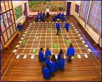
The basis of many maps is a grid. A grid is a space that has been broken up by vertical and horizontal lines into boxes. The other P6 class are in the school gym. A huge grid has been marked on the floor. There are letters along the bottom and numbers along the side. Each square has a grid reference. There are cards in some of the squares and each card has a letter drawn on it. There are three teams. Each team has to note down the grid reference of the cards. The letters make up a word. The word is co-ordinates.
An aerial view of a place is a picture taken from the air - sometimes it is called a "bird’s eye view". Many maps are based on aerial photographs. We see an aerial photograph of Hillsborough. Most maps show an aerial view of a place with horizontal and vertical lines placed on it.
Hillsborough is a very old village. It has changed a lot over the years. Many buildings have altered their use, for example, from homes to shops. New buildings are always being built, especially houses. But the basic street pattern of Hillsborough has remained the same. We see an old map of Hillsborough and a recent map of the village. The streets are in the same place. This is the same for many villages, towns and cities in Ireland.
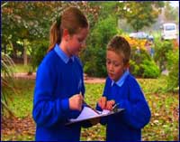
Five of the P6 class have been set a challenge. They have a simple grid map of Hillsborough. Some of the main landmarks in the village are marked with an X. The pupils have to use the map to discover what the landmarks are. One of them, Sophie, has to make a symbol of each landmark. Tony also has an aerial photograph of the village to help them.
We follow the five pupils as they use their maps to find the different landmarks around Hillsborough.
"Setting the map" is an important skill in using maps. We see Sophie and Sarah set their map at the bottom of the village. It helps them to see where they are and where the next X is. We see Tony and Alastair use the aerial photograph to follow the route they have taken so far from the school.
There are four compass points - north, south, east and west. The four points of a compass are very important in making and using maps. Maps are usually made with the top of the map facing north, the bottom facing south, the right hand side facing east and the left hand side facing west. The second X is St.Malachy’s Church. Inside Simon, head of the bell-ringers, has a modern official map of Hillsborough. Simon explains that the church is like a big compass. It is built in the shape of a cross. He explains that there is a west door and an east window.
Symbols on maps show us where places are and also give us information about them. A symbol is a small picture of a landmark or feature in the landscape. A symbol represents them on the map. Good symbols are easy to understand. St.Malachy’s Church has a huge spire. Sophie has to represent it with a symbol. She has chosen a triangle.
Maps are always drawn to scale. This means that a small unit of measurement on the map - for example a centimetre, might represent a larger distance on the ground. So a centimetre might represent 200 metres on one map or it might represent a kilometre on another. The simple grid map is drawn to scale. Each side of a box represents 200 metres. The five pupils can use it to estimate how far one X is from another. They can see that the next X is about one side of a box from the church. It must be about 200 metres away.
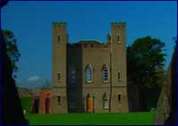
Maps help us understand the shape and layout of places. The next X is Hillsborough Fort. Both the grid map and the aerial photograph show its shape very clearly. It is built in the shape of a square with small "bastions" on each corner. Inside the fort there is a gatehouse. The fort was built on the site of an ancient homestead or "rath". It had a circular shape. This can be seen on both the aerial photograph and the up to date map of Hillsborough.
In the programme the pupils use the map to find their way from Hillsborough Fort to the next X, the courthouse. They then go west into the grounds of Hillsborough Castle to discover another X, the Lady Alice Temple. It is beside a pond.
It is always important to look around for landmarks and features in the landscape. If you have "set your map" correctly it is easier to see where they are. We see the pupils doing this.
In the final section of the film the pupils meet John from the Ordnance Survey of Northern Ireland. His job is to make the official maps of places in Northern Ireland.
John checks how the five pupils have got on with their challenge. We see the symbols that Sophie has made to represent each of the landmarks they have found. We learn from John that symbols are very important because they are a very simple way of giving us information about a place. It would be very difficult to use words to describe landmarks and features on a map. Symbols can do this very clearly but they must be easily understood.
New technology is now used to make maps. John uses a "pen computer" to help him in his work. John highlights something on his pen computer. It shows the marks "BM 94.39" in the school grounds. The letters BM represent the words "Bench Mark" and the figures "94.39" show the height of the mark above sea level. So the mark is 94.39 metres above sea level.
Maps need to be altered all the time. They change because places change. Fields can be turned into housing estates. Old buildings are often knocked down and replaced. New roads are built. John compares a map of Hillsborough that was made in 1800 with a map that was made in 2000. While the street layout is the same and places such as the church are in both maps, Hillsborough Primary School is not on the old map. So it must have been built after 1800.
Maps are used by different kinds of people and for many different purposes. Just as mountaineers like Dawson Stelfox use special maps to help them find their way around mountains, we learn that nurses and postmen, for example, need to use other kinds of map for their work also.
Maps are full of useful and interesting information. But you have to learn how to read them.