 |  |
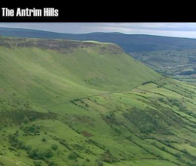
The Antrim Hills, or the Antrim Plateau are part of a broad band of basalt that stretches across Co. Antrim. Rising to 360m, this upland area descends steeply to form the nine glens of Antrim. This is the Garron Plateau and is one of the last untouched wild areas in Northern Ireland. As we go higher up the soil becomes less fertile, the climate gets colder and wetter. The small scattered loughs are evidence of poor drainage where the soil is too wet for farming. Garron Plateau has been designated a Special Area of Conservation because it is the largest area of intact upland Blanket bog in Northern Ireland and is home to many species of peatland flora and fauna. Garron plateau descends abruptly into the steep sided valley of Glenariff. Like the other Glens the land is lower, drier, warmer and more fertile making it more suitable for farming and settlement. Forestry is found in sheltered valleys like here in Glenarm. As the land gets higher the soil gets poorer and good land gives way to poor quality land suitable only for sheep. Like the Mournes, the Antrim hills' scenic views attract many visitors and leisure and Tourism has become its main economic activities. North of Glenariff the land rises steeply to the slopes of Lurigethan exposing the layers of basalt which make up the Antrim Plateau. Like granite, basalt is a result of volcanic activity. Unlike granite the magma reached the earth's surface and cooled quickly forming smaller crystals. It formed a lava plateau which covers an area of about 1650 Km2 which runs from the Giant's Causeway to the Cave Hill near Belfast. | The Antrim Hills, or the Antrim Plateau are part of a broad band of basalt. Rising to 360m, this upland area descends to form the nine glens of Antrim. Garron Plateau is covered in blanket bog making it unsuitable for farming or settlement. Down in the Glens, the land is drier, warmer and more fertile making it more suitable for farming, forestry and settlement. Like Granite, basalt is a result of volcanic activity. Unlike granite the magma reached the earth's surface and cooled quickly. |
16 October 2014 |
 |
