
There was some dramatic weather last night with thunderstorms in parts of mid, west and south Wales.
This picture of fork lightning over the Bristol Channel was taken by Jac Osborne from Barry.
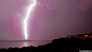
Lightning in Barry Island last night. Photo: Jac Osborne
There will still be a few hit-and-miss heavy and thundery showers this evening with a yellow warning in force covering most of the country until midnight.
Overnight, the showers will gradually clear away eastwards.
Tomorrow mist and low cloud will lift during the morning, leaving most places dry and bright at times with sunny intervals.
However, a few showers are possible, mainly in the south where they could be heavy.
Highest temperatures will be in the south reaching 20 or 21°C. It will be nearer 17°C on the north coast with a breeze off the sea.
Tomorrow night there may be a few showers in north Wales otherwise dry with clear spells and a cooler, fresher night than of late.
On Sunday high pressure will be back in charge of our weather centred over the UK which will mean a nice day.
Any mist or fog patches first thing will soon clear leaving sunny spells.
Cloud will develop but it will stay dry and it will turn out pleasantly warm; top temperatures of 16 to 18°C with light winds and lower humidity.
Next week will start dry and settled but a cold front will bring a little rain by the middle of the week, the wind picking up as well, however parts of the south and southeast may stay largely dry.
