
It's been a wet month so far, especially in the southwest of Wales. At Scolton Country Park over 140mm of rain, 5 inches, has fallen. That's nearly a month's worth of rain in just over a week!
We've had hail and thunderstorms as well with above-average sea temperatures giving showers extra energy, and there was some spectacular lightning in Porthcawl and Swansea last night.
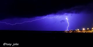
Lightening over Porthcawl by Tony John
Over the next few days there's plenty more rain and showers to come - some heavy downpours and strong winds as well with low pressure over the Atlantic.
A Met Office rain warning is in force for southern counties of Wales valid from this evening until Wednesday morning.
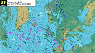
Forecast chart for Tuesday 11 November
The rain will be heaviest on high ground in the south; on the Brecon Beacons 60 to 80mm of rain is predicted with some surface water and river flooding likely.
Tomorrow night will bring yet more rain, this will be heavy and possibly thundery in places. Later in the night it should turning clearer and drier with a few showers. Wednesday will be brighter; some dry weather and sunshine but showers as well, the showers heavy in places with hail and thunder. Thursday morning should be mainly dry and bright but the wind will increase with rain arriving during the afternoon and evening.
Thursday night into Friday could be very wet. There is a heavy rain warning in force for mid and south Wales with a risk of some flooding. On Friday the rain will clear; it will then brighten-up with some sunshine and a few scattered showers.
So rainfall totals will continue to build-up this week, especially in the south and west. Watch out for poor travelling conditions at times as well.
