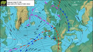
The weather is on the change again tonight with a warm front moving east bringing in milder, wetter and windier conditions from the Atlantic. Some heavy rain is likely, especially on the Cambrian Mountains, with 30 to 50mm of rain expected tomorrow. The Met Office has issued a warning for this rain.
South-westerly winds and tropical maritime air will bring a lot of moisture in from the Atlantic. Generally, as the moist air hits the Welsh mountains it is forced upwards producing more clouds and rain - the technical term for this process is 'orographic enhancement'. See 'Why does it rain?' for a definition (rainfall can actually be as much as 10 times greater over the mountains than it is on the coast, depending on the strength of the wind and how moist the air is).

More rain and drizzle is expected tomorrow night into Thursday, with strong to gale force winds. The rain will continue to be heavy at times, especially on the hills and the mountains of mid, west and northwest Wales, and as the ground is already saturated, there is a risk of some flooding of low lying land; see Natural Resources Wales
Northeast Wales and the Marches will receive less rainfall than the northwest, as they will be in a rain shadow (see here for a definition of this term), but river levels will start to rise.
By Friday morning, the heavy rain will clear away and will be followed by much drier, clearer and colder weather, though with a few showers. It will even be cold enough for snow on the summit of Snowdon.
See the Met office weather summary.
