Temperatures to plummet as more ice and snow warnings come into force
- Published
Temperatures will plummet overnight, bringing in the first widespread frost of the month and a series of ice and snow warnings for Saturday.
The drop in temperatures marks a significant change in our weather after weeks of record-breaking damp courtesy of a "blocked" weather pattern., external
Saturday will start off cold and frosty but the whole of the UK will be seeing some sunshine in what should be the driest day for a good while.
But come the evening, and into Sunday, as Atlantic low pressure moves in, there will be the risk of more snow, potentially even at lower levels, before the front clears through – leading to sunny spells and scattered showers on Sunday.
More weather warnings are coming into force
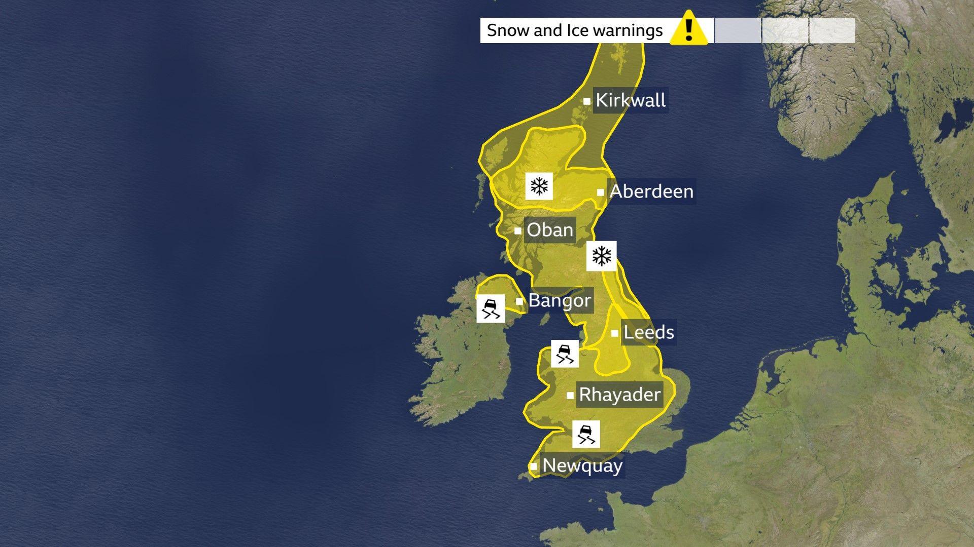
Met Office weather warnings are becoming more numerous as the Arctic air advances south.
Two yellow warnings for snow and ice are now in effect and will remain in place until Saturday morning. The warnings cover northern Scotland and parts of North East England.
An ice warning is also in place in the northern part of Northern Ireland, including Londonderry, Coleraine and Belfast, from 20:00 GMT on Friday until 10:00 on Saturday. Another ice warning for Wales, South West England and the East Midlands will also expire on Saturday morning.
A further yellow snow and ice warning will come into force at 21:00 GMT on Saturday for Scotland, North East and North West England. It will expire at 10:00 on Sunday.
Keep checking the BBC Weather website and app for all the latest details.
And the hour-by-hour forecast for your area is always available on the BBC Weather website and app.
How to drive in snow and icy weather
- Published2 January
How to look after dogs, cats and other pets in cold weather
- Published4 January
Cold health alert issued
In response to the forecast Arctic blast, the UK's Health Security Agency has also issued yellow health alerts, external for the colder weather across northern England and the Midlands, which remain in effect until 08:00 Monday.
They warn that the weather is likely to have "minor impacts on health and social care services, including increased use of healthcare services and a greater risk to life of vulnerable people".
Temperatures will stay below average over the weekend, returning to more of what we would expect by Tuesday.
How do cold weather health alerts work?
- Published1 day ago
Are wetter winters and frequent flooding here to stay?
- Published2 days ago
Rain and snow to follow first frost of the month
The wintry mix of rain and hill snow will continue to move south across central and southern England along with Wales but should clear southwards to exit the south coast around midnight. It is behind this that the cold air is digging in.
So we can all expect a much colder night with the first widespread frost of February and, following the rain and snow, there will be the risk of icy stretches on roads and pavement.
Further sleet and snow showers will persist through the night across parts of northern and eastern Scotland as well as north-east England.
Some fog patches are also likely to form in prone places too.
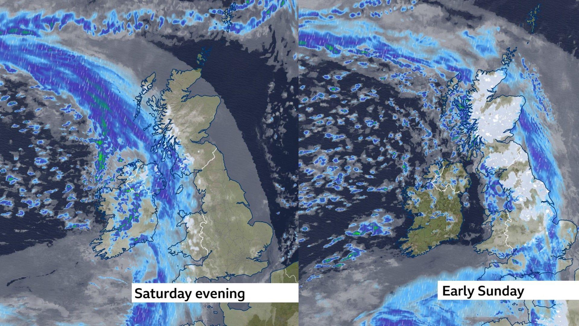
Saturday will be cold and crisp to start but with an abundance of sunshine and at long last, a mostly dry day is forecast with some widespread wintry sunshine.
The next band of rain will approach from the west during Saturday evening and overnight into Sunday.
As this bumps into the colder air, another spell of snow is forecast for parts of Wales, the Midlands, northern England, and Scotland. It is possible we might see a smattering of snow further south, so do stay up to date with the forecast
Record Aberdeen gloom has ended

Finally a proper sunny day in Aberdeen
It has been wet and grey for many parts of the UK - none more so than the city of Aberdeen in north-east Scotland.
After three weeks of gloom the Sun finally made a welcome return to the skies between 15:00 and 16:00 on Thursday afternoon.
Although its appearance only lasted for just over 30 minutes it was enough to signal the end of the record breaking cloud cover the city had seen.
"It has been dreadful. It was dark from morning to night," Aberdeen resident Lorraine Ferguson told the BBC, adding that she is "absolutely delighted" by the return of the sun.
Friday is the day when the cycle was properly broken and sunshine has returned more widely.
Flood warnings remain
Across England more than 70 flood warnings remain in place, external
The Environment Agency's flood warning forecast for the next five days is highlighting the potential ongoing impacts from groundwater for parts of the south of England throughout the next five days. Continuing flooding impacts are also likely from rivers across Somerset and Wiltshire, York and parts of the Midlands on Friday, continuing into Saturday in places.
Properties may flood and there could also be travel disruption.
Local surface water and river flooding impacts are possible for parts of England and Wales on Friday and Sunday, with impacts possible but not expected more widely throughout.
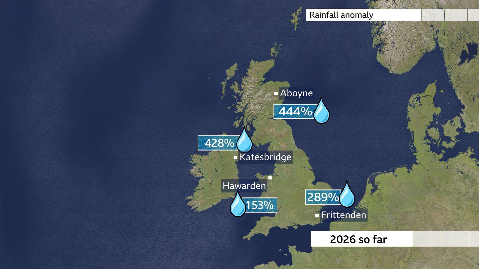
The wettest places have been in eastern Scotland, Northern Ireland and southern England, where weeks of relentless rainfall have led to very saturated ground and extensive flooding.
In January some areas had exceptional amounts of rain, notably Northern Ireland was the wettest since records began and February has followed suit.
Such that since the start of the new year Katesbridge has had over four times what we would normally expect.
As you can see from the rainfall chart it has also been incredibly wet in Aboyne, Aberdeenshire; the chart shows the percentage rainfall we have seen so far this year compared with the average amount we would expect to see up until mid February.
Get in touch
Have you been affected by severe weather in your area?
- Published23 hours ago
