Geologist and keen climber, Dr Tom Challands, challenges a pair of young people to climb The Roaches in the Peak District and investigate how the unusual rock formation was formed.
The video
Dr Tom Challands: Today the gritty sandstone Roaches in Staffordshire form part of the Peak District's National Park. Thanks to the eerie and stunning rock formations, it's popular with tourists who visit for walking and climbing.
I'm Dr Tom Challands, and I'm here today at the Roaches to challenge two young enthusiastic climbers and geologists by posing a geological question to them that they are going to have to answer by climbing up the cliff face here and collecting evidence.
Anna: I'm Anna. I am 16 years old, and I study GCSE geology. I like sort of finding out how things have formed, and how they evolve almost over the years.
Jonny: I'm Jonny. I'm 15 and I live in Cornwall. I enjoy geology, because I enjoy working in the field and collecting data and evidence.
Dr Tom Challands: Here at the Roaches, the sand that formed these rocks we have here around us today was deposited in an ancient river delta about 300 million years ago. If you have trouble imagining what this may be like, look at these pictures of a modern-day braided river. And what's happened since is that these rocks were consolidated, and compacted to form hard sediment. The hard rock that we are going to climb on today is that soft rock above, and below have been weathered away to leave a nice big gritstone escarpment. What's going to be very difficult for the children today is to make that relation between a modern environment and the ancient environment here. That's a key part of geology. It's about uniformitarianism, the present is the key to the past. So by reflecting on modern depositional environments, like the Mississippi Delta, hopefully they will be able to recognise some of those structures and some of those meandering river forms here in the Roaches rock.
Jonny, Anna, we're sitting here at the bottom of a rather misty wet Roaches crag and it's about time we gave you a challenge to do so we can get moving and get your brains ticking. Your challenge today is this.
Were the sediments that formed these rocks deposited in an ancient river delta or a deep marine environment and are they the right way up?
There's some paper there that you can make notes on and also choose four pieces of equipment from our geological kit box here. Choose wisely and choose them according to the challenge we have just set. They can choose four from this range of geological equipment. Some will be really useful on this climb - others will be useless. They don't know this area or the route they're going to climb. They'll have to find as many clues as possible to unlock the rock's history.
Jonny: I think it's a good challenge, and I'm looking forward to going climbing and collecting some evidence.
Anna: This might be useful for grain sizes.
Jonny: Oh, OK yeah.
Anna: We chose the hand lens so that we can look at the different grain sizes in more detail so we can see sort of where they are placed which should help us. I also chose the Geological Time Scale, because that means that we might be able to date round about when it was formed which might help us with our investigation.
Jonny: The other thing we chose was a compass clinometer, to work out the angle of the rocks.
Anna: We think it's going to go OK if we can find the right evidence to prove our investigation.
Dr Tom Challands: Jonny and Anna are both doing their GCSE geology, and know how important it is to look at the grain size and the grain shape of sedimentary rocks. So they've got a grain size card and a hand lens to look at the grains as well and that's brilliant. What they haven't taken is the notebook. They may spot all of these things, but they won't be able to write down their observations. It's very important to record your data. They've also got the compass clinometer and that will allow them to measure the direction of current flow in beds, and foresets cross-bedding that they might observe in the rocks. So, the weather's clearing up now, the rock's still a bit greasy hopefully if the sun does come out a bit and it will be just enough to dry off.
Anna: We're about to start climbing up the rock face, to find some evidence to see whether the sediments were deposited and which way up the rocks are.
Dr Tom Challands: If you don't know what you're doing, Anna and Jonny's field study challenge has its risks. It shouldn't be undertaken without expert help.
Jonny: I'm looking forward to it. I think it's going to be a good challenge.
Dr Tom Challands: Here you can start taking measurements almost immediately even before you start the climb. These large, rounded rocks Jonny is clambering over are ideal to take the first reading.
Anna: I've not got a pen.
Jonny: Got the chalk?
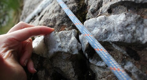
Dr Tom Challands: It's really important to use either chalk or a pencil when taking dip and strike measurements. It washes away, so there's no damage to the rock.
Jonny: I think the strike is measured at about 30. Does that sound about right?
Anna: Yeah, that sounds right.
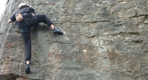
Dr Tom Challands: Jonny's making good use of the way the rock is eroded to help him climb. These cracks smooth ledges and the coarse gritty rock all help. One thing that Anna and Jonny may have found difficult is to tell the difference between bedding, and foresets of cross beds. Here, we can see clearly the difference. The bedding plane is at a shallower angle to the foresets that dip down, away from the bedding plane. And the foresets will give us an idea of the direction of current flow whereas by measuring the bedding plane, it just tells us some structural geological information. Jonny's doing well, wedging his hands and fingers into the weathered rock surface to pull himself upwards. This section is tough, and it being damp makes matters worse. Jonny needs to carefully balance and transfer his weight from foot to foot. Trust those feet Jonny. Trust them! Push down with your palms to push you up higher. Yes perfect. Excellent. Brilliant well done. Another chance to take some vital readings, he's making great use of this well-defined bedding plane to act as a ledge to stand on.
Jonny: It looks like it could be the front of crossbeds. OK it's 21. About… 20 It's definitely about 20 I think.
Dr Tom Challands: What this climb is allowing us to do, is get a really good profile through the rock section to see if the lithology, if the type of rocks are changing. And here we are about half way up the climb now and just having a quick look at it we still have the same type of sandstone. Being a Cornish granite climber, this should be second nature to you.
This is called a mantelshelf. He needs to push with his hands and arms to get his weight over the ledge. Really tough. Brilliant well done. Brilliant. Fantastic. At last after an agonising wait, Anna heads on up. So here on the climb it's worthwhile just looking at the grain size of the rock we have in front of us. And using this grain size card, we can quickly measure how big the grains of sand are in this gritstone. Simply compare the size of the grains. They seem to be a coarse sand, to a very coarse sand. With occasional larger pebbles of quartz, which are rounded sub-angular. Though the majority is this coarse sandstone.
The roundness of the grains tells us how far they've been transported from where they were originally weathered. A well-travelled grain is smooth and round. The more angular, the more local.
Speaker: That's the most important bit on this first section. It's all about your feet.
Anna: Oh!
Dr Tom Challands: You're doing really well here. It gets greener and slimier right above where you are there.
Speaker: That's it.
Dr Tom Challands: Yes.
Anna: Oh!
Dr Tom Challands: Anna's doing really well. The lower part of this climb is hard because there are so few defined bedding planes to provide good climbing holds.
Anna: I'm going to take another measurement here.
Dr Tom Challands: Anna's checking grain size, as it can tell us a lot about the energy of water flow. Large grains point to fast-flowing high energy water, whereas small grains indicate a lower energy. Further down there was, a few like coarser ones within the finer ones. But here there doesn't seem to be as many like coarse ones.
Dr Tom Challands: OK then. That's a really good observation.
Anna is climbing up a vertical joint here, very typical of grit stone. These joints allow the climber to wedge in their feet and hands, and to get good purchase. Well done Anna. You're doing well. Great. Quite large, but slopey rounded holes there. They missed a trick not picking the notebook, but full marks for taking the initiative and writing on their hands.
You can see just the rocks in front of us here isslightly slightly polished. Very clear if you look down at the slab see it's mostly green apart from the lighter-coloured areas, where people have been using little bits for their feet. So even on this tough millstone grit that was used to make grinding stones, it still does wear away and polish down a bit.
So, where the fine grain sand sediment is weathering away, it leaves these big ledges that weather and erode into these slopey surfaces. In climbing terms we call them slopers.
The top of this climb is so different from the base. Large joints have created a chimney effect, which is tricky to squirm up and through. Brilliant. Brilliant, well done. That's an almighty stretch. Fantastic.
So, just to remind you we asked Jonny and Anna to find out if the sediments that formed these rocks are from an ancient river delta or deep marine environments, and are they the right way up? We've got twenty minutes to look at your evidence and observations, and come up with an interpretation and conclusion to the question we asked you earlier on.
Jonny: OK.
Dr Tom Challands: Well done brilliant.
You've had some time to sum up your evidence. How's it been? Has it been easy or difficult?
Anna: Well, some bits have been easier than the others. It's easier to tell where it was deposited than which way up it is.
Jonny: We think it was a delta, because if it was a deep marine environment then there would be bigger grains at the bottom and smaller at the top. But it's been fairly consistent the whole way through, which indicates it might have been a delta rather than deep marine.
Dr Tom Challands: So rather than having sporadic influxes of sediment which then settle the coarse grains first medium, then going into fine mud we are just seeing sandstone, sandstone, sandstone.
Jonny: Yeah it's just a very similar thickness the whole way through.
Dr Tom Challands: Why is that like the river?
Anna: There is cross-bedding that indicates that there was a flow of water going over the bed when it was deposited and you wouldn't get that in deep marine because there is not usually a current.
Dr Tom Challands: But the way up structure then whether or not this is the right way up. Why did you struggle there?
Jonny: We just don't think that we got enough evidence to say which way up it was.
Anna: It wasn't like conclusive. There were sort of different things that indicated it was upside down, and things that indicated that it was the right way up.
Jonny: If it was the right way up it would be like a…is it concave?
Dr Tom Challands: Yeah that's right.
Jonny: Yeah and if it was the wrong way up it would be more…
Dr Tom Challands: Convex.
Jonny: Yeah convex. That's the one.
Dr Tom Challands: And you're saying that here, because they're so large, you can't really see the curve it just seems to be straight.
Jonny: Yeah.
Dr Tom Challands: I really like your interpretation of ruling out the deep marine environment, in favour of the delta. So well done guys. I think that was brilliant that you accepted that you just haven't got enough data to answer the second part of the question, and that's the way geology and science goes.
Today's challenge was all about the present being the key to the past - uniformitarianism. Let's look in detail what happened here. The Roaches, In Staffordshire. During the Carboniferous period, a very large river in a south-western direction on top of a massive river delta. It was charged with millions of tonnes of sand, eroded from the massive mountains to the northeast. The strength of the river current, water depth, and size of sediment grains produced mega ripples that moved down stream. The tops of ripples, were chopped off as new ripples then, but the dipping fronts are reserved as cross beds. These are the right way up, these are upside-down. Finer grained sediments form. Here's a calm, sometimes marshy area with muddy or fine sand. Here's a cross section through a delta sea transition. Rises in sea level intermittently deposit mud on the top of the delta, as it becomes flooded. When the sea level falls, the delta grows outwards to sea again. Repetition of the sea level rise-fall-rise produces mud-sand-mud cycles. Following burial, folding, uplift, and erosion, the soft mudstone weathers away, leaving harder sandstone standing proud, as the edges we enjoy climbing on today.
What was really impressive, was that they were not afraid to say that they didn't have enough information to answer part of the question. The day's been changeable, we've had some mist we've had some rain. I had good fun on the climb having had a little slip myself. But that is all part of climbing. Did I put my climbing shoes on?
Jonny: Really good way of combining climbing and geology together, which are two of my favourite things.
Anna: The climb was really, really good. It was really quite difficult at the bottom, and then it was a bit simpler in the middle because there were more handholds and footholds. And then the chimney bit was quite difficult and scary. And then we got pulled over the edge, and then you were done.
Video summary
Download/print a transcript of this episode (pdf).
Geologist and keen climber, Dr Tom Challands, challenges a pair of young people each to climb a rock face and see just what can be revealed from this unique vantage point, on the rock face rather than observing from the ground.
The climbs are not only technically demanding but throw up different field study challenges for the team to solve.
This location is the beautifully eerie Roaches in the Peak District National Park, Staffordshire.
Our climbers face damp conditions making their climb very slippy.
They are faced with uncovering evidence which should tell them under which conditions The Roaches were formed.
Can they say if the rock landforms are the still the same way up as they originally were?
Teacher Notes
Download/print the Teacher Notes for this episode (pdf).
Teacher Notes prepared in partnership with the Geographical Association.
Before watching the video
- Using a map locate the Roaches in the Peak District National Park. A geology map could also be used to see what types of rocks are prominent in this location.
- Look at the rock cycle and identify how sedimentary rocks are formed. You could look at examples of sedimentary rocks and what their characteristics are. It would be useful to have some sandstone samples to hand out to students so that they can touch and examine the rocks whilst looking at the characteristics.
- Introduce key terms such as:
Escarpment: an area of the Earth where the elevation changes suddenly.
Grain size: the diameter of individual particles in sedimentary rocks.
Bedding plane: a boundary that divides sedimentary rock into layers, called beds or strata.
Lithology: the study of rocks and their physical properties, such as colour, texture, and composition.
Weathering: the process by which rocks and minerals break down or dissolve on the Earth’s surface.
Uniformitarianism: the idea that Earth has always changed in uniform ways and that the present is the key to the past.
While watching
You may wish to stop at relevant points during this short film to pose questions and check understanding, or wait until the end. Useful questions might include:
- What equipment would you pick from the geological kit if you were carrying out this investigation?
- Why would it be important for the children to record their observations?
- What is the difference between bedding and foresets of cross beds?
- What type of rocks are the children climbing up?
- What characteristics does the rock have?
- Why was it important to compare the grain sizes at different heights?
- What is a vertical joint?
- What is the relationship between grain size and water depth?
After watching
- Discuss the investigation that the children carried out. Would the class do anything differently if they were carrying out the same investigation? Would they use the same equipment? Would they have carried out more measurements?
- Revisit the rock cycle. Why does sandstone have the characteristics it does? How are sedimentary rocks formed?
- Look at areas of the world where sandstone is prevalent. What do the landscapes look like? For example, you could look at the Cheshire Sandstone Ridge. How does this compare to the area we saw in the film? How was this location formed?
- Using samples of sandstones with different size grains, use a grain size chart to measure and compare. Why do some samples of sandstone have larger grain sizes than others. Think back to the film and what was discussed about water depth and velocity.
Where next?
- Examine igneous and metamorphic rocks. How they are similar and different to the sedimentary rocks we have examined in this film?
- Look at a geology map of the UK. Can igneous and metamorphic rocks be found in the UK? Is there a pattern to where they are found?
- What characteristics do igneous and sedimentary rocks have? If samples of these rocks are available, hand these out to students. Can students classify these rocks based on the characteristics discussed?
Links
UK landscapes:
https://www.bbc.co.uk/bitesize/guides/zsg639q/revision/1
Distribution of UK rock types:
https://www.bbc.co.uk/bitesize/guides/zsg639q/revision/2
Limestone landscapes:
https://www.bbc.co.uk/bitesize/articles/zd96xbk
Curriculum Notes
This clip will be relevant for teaching GCSE Geography and Social Studies. This topic appears in OCR, AQA, Edexcel, WJEC KS4/GCSE in England and Wales, CCEA GCSE in Northern Ireland and SQA National 4/5 in Scotland.
More from Rock Types at Great Heights
Castle Inn Quarry (Eryri - Snowdonia National Park) video
Two young people climb Castle Inn Quarry to study geology from a unique vantage point.
How the Cwm Idwal slabs were affected by tectonic activity. video
Two young people climb the Cwm Idwal slabs to study geology from a unique vantage point.