Geologist and keen climber, Dr Tom Challands, challenges a pair of young people to climb Cwm Idwal Slabs in Eryri (Snowdonia National Park) and investigate how they have been affected by tectonic activity.
The video
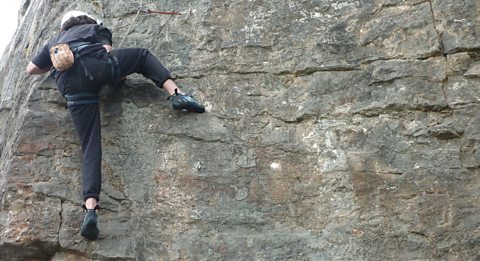
Dr Tom Challands: Today, we're in the Snowdonia National Park Wales. We'll be climbing the Cwm Idwal Slabs. These magnificent rocks were folded by tectonic activity around 400 million years ago. The movement of the Earth's plates crumpled and squashed the rock into new shapes. Volcanic eruptions, followed by glacial activity in the last ice age also helped to carve and shape the landscape. I'm Dr Tom Challands. I'm a geologist, and I'm also a climber. I'm here today, to challenge two young climbers and geologists to investigate the type of geological processes that contributed to forming these big cliffs that we see here behind us.
Over 450 million years ago, this was the site of a massive violent pyroclastic eruption the same type of activity seen more recently in Krakatoa. The area is important historically and not just for climbing. It's here, 170 years ago Charles Darwin tested the early theories of glaciation and glacial erosion, applying what he'd learnt from his earlier travels in the Alps.
Our first climber is Alex he's 15 and from Essex.
Alex: I study Geography and Geology at GCSE level, and I enjoy the field work in both subjects. I really love climbing, because I find it exhilarating and it challenges me puts all my skills to the test.
Dr Tom Challands: Maddie is also 15, and from Birmingham.
Maddie: I don't really have that many expectations, just have fun and try and learn as much as possible. Indoors it's set out for you. I'm going to have to think about what to do where to put my feet. It's raining, but that's not going to hinder me. I'm going to power through.
Dr Tom Challands: The weather's not very good. It's looking slightly tricky and slippy underfoot. They're going to have quite a big challenge ahead. It's still raining, but I'm going to set you the challenge still because I know you're made of stern stuff, and that you're keen and you're eager to get on with it.
So, here's today's challenge. Describe how the slabs have been affected by the tectonic history and later erosion of the area.
We've given Maddie and Alex 20 minutes to plan their tactics before climbing. To help, they've been given this box of tricks. They can choose four from this range of geological equipment. Some will be really useful on this climb - others will be useless. They don't know this area, or the route they'll climb. They'll have to use these items and their knowledge of geography and geology, to find as many clues as possible to unlock this rock's history. It's good they're looking at the bigger picture, and not just what they think they'll encounter immediately on the climb. This is the way to choose the best equipment.
Alex: That looks like an anticline, because it's bedded diagonally like that pointing upwards. You can see the nice beds on top of each other.
Maddie: We've chosen two compasses, with hand lens on the end a grain size card, which will help us measure the grain size, and a note book to write everything down. Obviously, you can see this is a U-shaped valley, so there must have been a glacier at one point here and there are truncated spurs.
Alex: There's a tarn which indicates as well there's a glacier there because it's a melted glacial lake.
Maddie: Yep.
Dr Tom Challands: They've jumped to a few conclusions about glacial activity in the area without any real evidence but… I've got a lot of hope for them. They're both very intelligent kids they're really on the ball and from what I've been hearing them discuss, they're going on the right lines.
Alex: We chose a compass, because it helps us measure the dip and strike of the rocks, and also it's got a hand lens on it which is helpful for telling grain size. We've picked a grain size card because as well as telling grain size which helps us identify rocks it also tells us how to measure sorting of grains roundness of grains and as well as that percentage area of coverage of the rock that the grain has. Which is all helpful in helping us identify rocks. I wanted to ask Dr Tom how to measure dip and strike again because I wasn't actually sure how to measure it. I have a rough idea but I want to be sure before I go up the cliff.
Dr Tom Challands: We're measuring the dip of the rock, because it lets us know if it's been tilted or folded. It's a real clue to the tectonic history, and it'll help with the challenge.
First of all, the dip of a bed of rock, is the angle at which it tilts the maximum angle that it tilts, and we can easily find the maximum angle of tilting simply by getting some water and we're not short of that today. If we drip a little bit on the rock, the direction the water will travel in is the direction of maximum dip. This compass also has a small dial on the inside of the actual circular part here. What we want to do, is align the compass so East and West are lined up with the arrow at this end. The dial here which goes from zero degrees at the bottom to 90 degrees at the side is horizontal when we have the compass in this position. You're then going to place it on the piece of rock you want to measure the dip of, and what's very important is to make sure it's a solid piece of bedrock, not a loose boulder because a loose boulder will give a false reading. We're going to move the compass clinometer around, until this arrow here stops moving back and forth. It seems to be pretty still there and it's reading 21 degrees. Then what we do, is use a pencil draw along the rock along the edge of the compass. It's very important to use a pencil or a piece of chalk something that will wash away. We don't want to scratch or damage the rock. We'll take our compass, and now lining our compass up with that line we've just made. We then rotate the bezel here the dial until the red arrow in the middle lines up with the red floating arrow, and the number that reads at the top of the compass clinometer here and in this case it's 268 degrees is the direction of dip. Here we have a dip of 21 degrees, we have a dip direction of 268 degrees, and the strike which goes two ways is 268 minus 90 or plus 90 degrees. So, we have our strike, dip, and dip direction.
Alex: That's much clearer definitely.
Dr Tom Challands: Brilliant, so now you've chosen your piece of equipment you know what measurements you're going to make, how to make them, I think we should go and do the climb and collect some data. How does that sound?
Alex: Sounds good.
Dr Tom Challands: Right. Let's go and do that then.
This field study is also a climbing challenge,s o if you don't know what you're doing it has its risks. Got all the gear? These climbs shouldn't be undertaken without expert help.
The geology is really helping the climb. This huge crack which could be a joint or a fault is really useful and is revealing some early clues.
Alex: Maddie there's a little line of like quartz in the middle.
Dr Tom Challands: The crack here, is the defining feature of this rock face. How it was formed will help them with the challenge. They just need to look for evidence which will tell them if it's a joint or a fault.
Looking into the depths of the crack, there don't appear to be any broken up bits of bits of rock, like we might expect from a fault. Those broken up bits of rock are actually fault breccia. Now, if we can't see that fault breccia in here that might indicate that it's not a fault, but rather a joint.
Alex: In this crack, there's a massive lump of quartz. If that has significance, I'm not sure.
Dr Tom Challands: It's great to see Alex and Maddie noticing the changes in the rock as they climb and looking for solid areas to take their readings.
Alex: Different strike readings.
Dr Tom Challands: They've obviously taken on board the mini briefing on using the compass clinometer and are making frequent measurements as they climb.
Alex: OK.
Dr Tom Challands: It might be simple, but that notebook is vital or they'll never remember their results. Two or more set of cracks can reveal how the order of events happened in the rock but what they can't reveal is how long it took. You need to gather other evidence for that. So, I'm a little bit further up the climb now and I've found another set of cross cutting joints cutting across the main fracture here but what else we have is vegetation growing in this fracture. This is an example of biological in situ weathering.
Alex: Look at that! This looks like this parent rock right here this obviously is some quartz which begs the question how it got there. Little parts of quartz some bigger some smaller some really small ones a yellower one and a more grey one which indicates some type of weathering possibly or something else in the rock.
Dr Tom Challands: These loose bits of quartz Alex has found washed in here, are great examples of weathering and erosion. What we have here on the surface of the slab are some quartz crystals. A quartz bedding plain almost. This is actually a quartz injection that's a vein that's injected along the bedding plane itself. This is the final measurement of the climb. They've taken one at the base one in the middle and now we're at the top of the climb just taking one more.
So, from this vantage point in the climb, we have a really good view of the head of Cwm Idwal the large synform right at the heart of the Cwm.
It's the curves you can make out in front of me on the rock face. We can also make out a large periglacial landslide below it. There's a clue to the glacial past of this area in the name Cwm as in Cwm Idwal. It's the welsh word for corrie, and a corrie is a glaciated mountain valley. Further down at the foot of the slabs, we have roche moutonnees. A bit further down by Cwm Idwal there are also some very, very clear moraines. So, we're starting to get a good picture of the geology and geomorphology.
OK guys, I think it's time we got down now.
Alex: Hands off the rock. In back now. That's it. That's it. Just like being low down on the climbing wall.
Dr Tom Challands: Maddie and Alex abseil back to base. This'll give them one last chance to look at the structure and spot any last minute bits of evidence. I'm quite confident that they've got a good idea of what's happened here in Cwm Idwal. We're looking at the bigger picture. They looked at it before they went up the route they looked at it when they got to the top of the route and they also made some small-scale observations and measurements as well. So you've seen what I think. Now they've got 20 minutes to pull together their evidence and see if they can answer the question. So, we asked them to describe how the slabs have been affected by the tectonic history of this place and what caused the subsequent erosion?
Alex: We found quite a lot of evidence actually from erosion to different rock types and minerals. And I think all of it will definitely help us with our question.
Maddie: We just need to sit down together, and confer, and relay back our different information, and then try and find out something concrete that we can put forward for the question.
Alex: There's quite a lot of quartz up the joint that we found. That might be from a hydrothermal ore vein, which is tectonics because of the magma that's come up in an igneous intrusion somewhere around here. That's heated rainwater that's percolated through the ground and as that rain water comes up it collects minerals such as quartz. We found some trachopyrate as well which is another mineral that we would find. Obviously, it carried it up and as it went up it cooled and solidified in these joints. Obviously, the tectonic activity has created these quartz hydrothermal ore veins. The compass clinometer helped us measure three different dip and strike angles and the direction of dip.
Maddie: It increased in steepness as we went up. At the beginning it was 42 and then mid-point it was 52 and at the top the final reading was 60.
Alex: It helps us see how the rock's been affected as it goes up for example if it's steeper at the top less steep at the bottom.
Dr Tom Challands: This is a great point to spot, because we were climbing on the limb of this fold we can see here.
Maddie: I think the main erosive features are definitely the truncated spurs that you can see and the moraine you can see it everywhere.
Dr Tom Challands: OK. And the main structural features?
Alex: The quartz veins. The way the joints are facing as well and all the other evidence for erosion with smooth rock.
Dr Tom Challands: So, the structure has contributed towards the erosion and weathering. That's a lot of good interpretations based on your observations and that's exactly what geologists do.
So, today's challenge was all about the effects of tectonic activity and glacial erosion. Let's look in detail at what actually happened here. We start with the deposition of volcanic rocks tuffs and lavas during the subduction of the Laurentian plate beneath Avalonia and Baltica. Scotland England and Wales are united for the first time. Leading to the Caledonian mountain building period event. Layers of rock are bent under extreme pressure, and hot briny hydrothermal fluids formed during the collision deposit minerals such as quartz inside the newly-formed cracks. Until the ice age. But this landscape is forever changing due to further erosion because of melt water and vegetation as well as wind and rain.
Maddie: The geology challenge was pretty hard but I did learn from it. I was quite scared to do the climb, but actually when I did it it was really fun. I'll probably take away learning not to be afraid to try new things and even if something's wrong, always just say it because there's a chance that it might include something that could be developed on.
Alex: Today's actually taught me definitely a lot more about geography. Some of the things we found, like the truncated spurs I did not know about them. Without Maddie, I would have completely missed all that. I would definitely do it again if I could.
Dr Tom Challands: So, that's it's for today here on Idwal slabs. It's been an adventurous day for climbing for geology and most certainly adventurous weather. Still to come we'll look at a rock face affected by human activity.
Video summary
Download/print a transcript of this episode (pdf).
Geologist and keen climber, Dr Tom Challands, challenges a pair of young people each to climb a rock face and see just what can be revealed from this unique vantage point, on the rock face rather than observing from the ground.
The climbs are not only technically demanding but throw up different field study challenges for the team to solve.
The location is the Cwm Idwal Slabs in Eryri (Snowdonia National Park).
The challenge is to investigate how the Cwm Idwal slab they tackled was affected by tectonic activity in the past and to spot the evidence which identifies the cause of subsequent erosion.
Teacher Notes
Download/print the Teacher Notes for this episode (pdf).
Teacher Notes prepared in partnership with the Geographical Association.
Before watching the video
- Using a map locate the Cwm Idwal Slabs in Eryri (Snowdonia National Park). A geology map could also be used to see what types of rocks are prominent in this location.
- Look at the rock cycle and identify how each type of rock is formed. You could look at examples of each type of rock and what their characteristics are. It would be useful to have some rock samples to hand out to students so that they can touch and examine the rocks whilst looking at the characteristics.
- A range of glacial landforms can be seen in this film. Look at images of glacial landforms before watching, so that students can try to spot them in the film.
- Introduce key terms such as:
Anticline: an arch-like fold in rock strata where the layers bend downward in opposite directions from the crest, with the oldest rock layers typically found at its core.
Truncated spurs: a steep, rounded landform that occurs at the edge of a valley.
Tarn: lakes that form in hollows formed by glaciers.
Parent rock: the original, un-weathered rock from which younger rock or soil form.
Moraine: a mound or ridge of debris left behind by a glacier.
While watching
You may wish to stop at relevant points during this short film to pose questions and check understanding, or wait until the end. Useful questions might include:
- What equipment would you pick from the geological kit if you were carrying out this investigation?
- Which glacial landforms can be seen in the film?
- What was used to measure dip and strike?
- What is biological weathering?
- What is a cwm? What is another name for it?
- How were the slabs affected by tectonic activity?
- What evidence of erosion was there?
After watching
- Discuss the investigation that the children carried out. Would the class do anything differently if they were carrying out the same investigation? Would they use the same equipment? Would they have carried out more measurements? What suggestions can the class come up with?
- Carry out research into Cwm Idwal. What types of rocks can be found there? What impact has glacial erosion had on the landscape? Students could research deeper into The Pitts Head Tuff Formation and Darwin’s Boulders to look at specific areas of geology.
- Look at the methods for measuring dip and strike. How are these carried out? Students could create a step-by-step guide on how to carry out the measurements, ready for any fieldwork that they might undertake. Students could be shown a range of locations with interesting rock strata. They could use these to practice the technique of field sketching.
Where next?
Research into a range of geology fieldwork techniques such as:
- Field sketches
- Photography
- Using a clinometer
- Using geological maps
- Measuring grain sizeHow would each of these methods enable you to learn more about the rock types and processes at a geological fieldwork location?
Links
The rock cycle:
https://www.bbc.co.uk/bitesize/articles/z2xx6g8
UK landscapes:
https://www.bbc.co.uk/bitesize/guides/zsg639q/revision/1
Distribution of UK rock types:
https://www.bbc.co.uk/bitesize/guides/zsg639q/revision/2
Glacial landforms:
https://www.bbc.co.uk/bitesize/articles/zwjdwnb
Glacial processes:
https://www.bbc.co.uk/bitesize/articles/zdw8dp3
Curriculum Notes
This clip will be relevant for teaching GCSE Geography and Social Studies. This topic appears in OCR, AQA, Edexcel, WJEC KS4/GCSE in England and Wales, CCEA GCSE in Northern Ireland and SQA National 4/5 in Scotland.
More from Rock Types at Great Heights
Castle Inn Quarry (Eryri - Snowdonia National Park) video
Two young people climb Castle Inn Quarry to study geology from a unique vantage point.
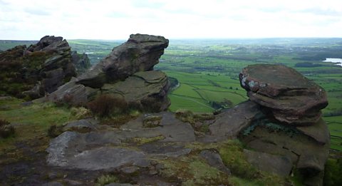
How The Roaches in the Peak District were formed. video
Two young people climb The Roaches to study geology from a unique vantage point.