Summary

Media caption,

BBC Weather's Darren Bett gives us the forecast for the week ahead

  1. It's not quite Arizona, as one ultramarathon runner's preparations 'washed out'published at 13:50 GMT

    Rozina Sini
    BBC News

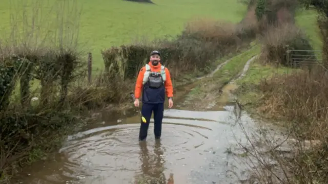
    Andy Kinghan standing in a puddle on a country laneImage source, Andy Kinghan

    I've just spoken to Andy Kinghan from Castle Cary in Somerset. He's training to take part in the 250-mile Cocodona ultramarathon in Arizona in May, but the weather has been hampering his efforts.

    "I've been getting soaked," he says. "I'm training using my local routes around Castle Cary but it's all washed out."

    "It's horrendous having wet feet and being knee deep in water in some places."

    He says if the weather gets too bad he'll continue training indoors, but that its "not the same" as the rough and mountainous terrain he'll be tackling in Arizona.

  2. ‘I’ll have to get armbands if this keeps up’, says rural residentpublished at 13:39 GMT

    Polly Bayfield
    BBC Newsbeat reporter

    A submerged path in Northern Ireland

    Nicole Fitzpatrick, from Ballynahinch in Northern Ireland, says her living room is filled with pots and pans collecting rainwater which is leaking from her roof due to the constant rain damaging her home.

    “My roof in my living room has started leaking. I’ve lived in this house my whole life and that has never happened,” the 28-year-old tells BBC Newsbeat.

    She says she has been constantly calling her dad for help, who she’s dubbed “Bob the builder”, because she is “terrified the house is going to flood”.

    “I’ll have to get armbands if this keeps up,” she says.

    Due to so many roads around her area in rural Northern Ireland being closed due to flooding, she hasn’t been able to go into the office or see family who live up the road.

    “It’s definitely a lot worse than it was previously.”

    When the clouds finally part, she says she is excited to just go outside without coats and umbrellas in tow.

  3. Drivers warned of aquaplaning risk on flooded roadspublished at 13:21 GMT

    A flooded road in StaffordshireImage source, BBC Weather Watchers/Videoman
    Image caption,

    Flooded roads like this one in Staffordshire can present a danger to drivers

    Road users are being warned about the dangers of aquaplaning as water accumulates on slippery surfaces.

    According to the Royal Society for the Prevention of Accidents (RoSPA), this occurs when a layer of water builds up between a vehicle’s tyres and the road surface, causing a dangerous loss of traction.

    This can mean drivers are unable to steer, break or accelerate effectively.

    As a result, the RoSPA's safety manager Caitlin Taylor advises drivers to reduce their speed in wet conditions, and ensure tyres have adequate pressure and tread depth.

    If you find yourself aquaplaning while driving, it says, you should remain calm, ease off the accelerator, and avoid sudden braking or sharp steering to regain control.

  4. Highways worker hit by car driving through floodwaterpublished at 13:05 GMT

    Vicky Castle
    BBC News

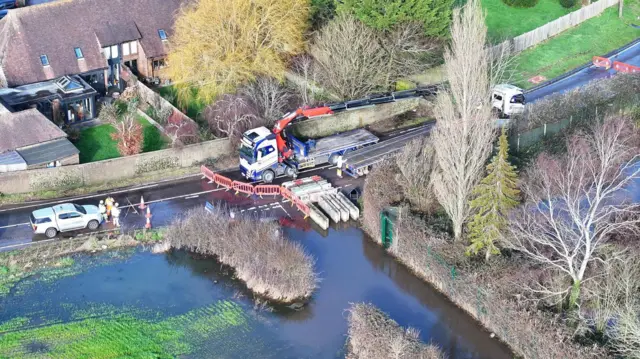
    A drone image of a flooded junction. Water covers a huge area of road. The road is fenced off and there are two lorries dealing with the floodImage source, Eddie Mitchell
    Image caption,

    The A29 Shripney Road is closed at the Saltbox Roundabout in Bersted, West Sussex, due to flooding

    A highways worker has been hit by a motorist who ignored a road closure and drove through flood water, say West Sussex County Council.

    The council says a white Land Rover pushed through barriers on a closed section of the A29 on Monday morning, hitting a member of the highways team who was dealing with the flooding.

    It adds that the worker was not injured, but that the matter has been reported to the police.

    It comes as "exceptionally high water levels" has led to a number of road closures, with two flood warnings and 17 alerts in place across the county.

  5. When is the rain going to stop?published at 12:50 GMT

    A puddle on a footpath in Stoke-On-Trent with gloomy skiesImage source, BBC WEATHER WATCHERS/STAFFORDSHIRE LAD

    It's the question everyone's asking, and the good news is that this current blocked pattern does show some signs of breaking down by the end of this week.

    Low pressure makes some progress eastward on Saturday which will lead to a northerly wind.

    While this will bring lower temperatures and some wintry showers, for most it will be drier and sunnier compared with recent weeks.

    However, this will be a very brief break. Rain will return on Sunday with a strengthening wind.

    And as the rain hits the colder air from Saturday, there will be a temporary spell of snow even to low levels for a time across northern England and Scotland on Sunday morning.

    The weather into next week then remains unsettled with further spells of rain and therefore the continued risk of some localised flooding

  6. Aberdeen goes weeks without sunshine in gloomy start to yearpublished at 12:33 GMT

    Ken Banks
    BBC Scotland, North East Scotland reporter

    Aberdeenshire with a flooded car parkImage source, BBC WEATHER WATCHERS/WELLIBOBS
    Image caption,

    It's been a gloomy start to the year on Scotland's east coast

    With Met Office yellow rain warnings currently capturing parts of east Scotland; here's how our reporter in the region has been finding the wintry conditions.

    Here in Aberdeen, the last time we had any recorded sunshine was on 21 January.

    So, from 22 January to today, we now have had 19 full days without seeing the large glowing ball of heat and light that is apparently somewhere up there in the sky.

    The first ten days of 2026 were bad enough, as we had nothing but heavy snow.

    Since then it has barely stopped raining.

    So is there any light at the end of the tunnel?

    Forecasters say it's unlikely we'll see any sunshine before Friday as colder Arctic air starts to push south, bringing the chance of one of or two snow showers.

    But Saturday could hopefully see some sunshine finally arrive.

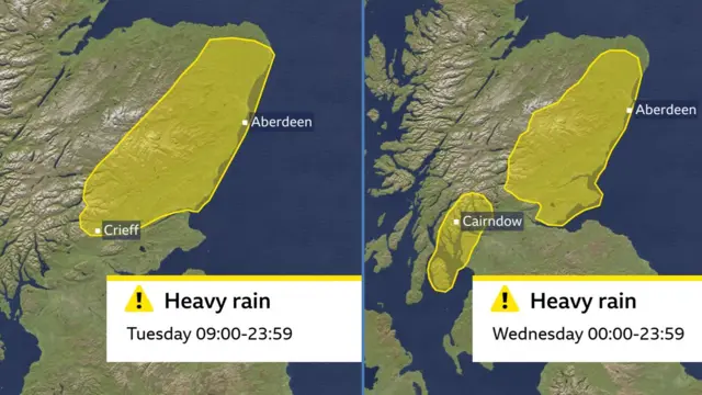
  7. Fresh yellow Met Office rain warning added for south-west Scotlandpublished at 12:18 GMT

    Sarah Keith-Lucas
    Weather presenter

    A map showing yellow weather warnings
    Image caption,

    A fresh warning for rain in south-west Scotland has been issued by the Met Office for Wednesday

    The Met Office has just updated the yellow rain warnings issued for Scotland over the next two days.

    As we reported earlier, a yellow rain warning is in place for parts of eastern Scotland until 23:59 GMT on Wednesday.

    Now, in an update, part of the west coast of Scotland has also been added to Wednesday’s warning in the east of the country.

    This will take effect from midnight on Tuesday, and is in place until 23:59 on Wednesday.

  8. Latest flood warnings for England, Scotland and Walespublished at 12:00 GMT

    100 flood warnings are currently in place for parts of the UK, with more rain on the way.

    Here's the latest:

    • Scotland is covered by two flood warnings and seven flood alerts
    • In England, the Environment Agency has issued 98 flood warnings
    • In Wales, three flood alerts are currently in force

    Stay with us for the latest weather warnings and how the conditions are impacting areas across the country.

  9. Birmingham's roads flood as closures in placepublished at 11:54 GMT

    A road closed signImage source, PA Media
    Image caption,

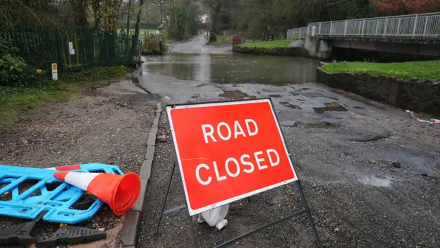
    Green Road in Birmingham's south-east has been closed by local authorities as floodwater makes driving unsafe

    A van drives through a flooded roadImage source, PA Media
    Image caption,

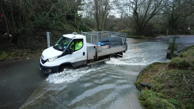
    Houndsfield Lane in south Birmingham is also battling with the elements

    A car drives through floodwaterImage source, PA Media
    Image caption,

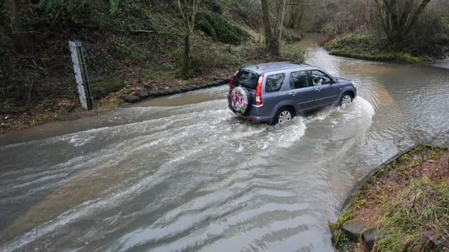
    The BBC's weather team is forecasting rainfall to continue for another few days

  10. If it feels like the rain hasn't stopped this year, you might be on to somethingpublished at 11:37 GMT

    Chris Fawkes
    BBC Weather presenter

    A map of January 2026 rainfall totals. In the background is a black and white image of extensive flooding around Fordgate and Moorland in SomersetImage source, MET OFFICE/BBC
    Image caption,

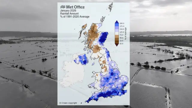
    A map of January 2026 rainfall totals. In the background, extensive flooding around Fordgate and Moorland in Somerset

    Parts of the UK have been hit with a real deluge so far this year with Cornwall and County Down recording their wettest January on record.

    It's been particularly wet in southern England, Northern Ireland and East Scotland. If it feels like the rain just hasn't stopped this year, you might be on to something, Cardinham in Cornwall has recorded some rain every single day of the year so far!

    Katesbridge (County Down) and Aboyne (Aberdeenshire) recorded nearly 4 times their January average rainfall, and history is repeating itself this month.

    We're not even at the half way point of the month and Aboyne has already had well over double the February average rainfall.

    Why so wet?

    Around the 17th January a blocking area of high pressure developed in Scandinavia, it's still there to this day.

    This has prevented areas of low pressure from moving beyond the UK so they've become slow-moving bringing very wet weather, with southwest winds to the south of the UK and southeasterly winds to the north of the UK.

    This wind pattern is responsible for the distribution of rain. It's worth pointing out that it hasn't been wet everywhere. Northwest England and west Scotland had a much drier January than normal, and parts of the Highlands have only recorded 1mm of rain so far this month.

    This Scandinavian blocking area of high pressure is finally going to budge this week, as it does our weather patterns will become more typical next week.

    There will still be rain around as we'd expect in winter, but some of the wettest weather will return to west Scotland.

    The rain won't be as extreme in east Scotland. In the southwest of England, it won't rain every single day, there will be drier and sunnier days between weather our systems.

  11. Flooded roads after soggy start to February - in picturespublished at 10:59 GMT

    It's been a soggy start to the month after what was the wettest January on record for parts of the UK.

    The wet weather isn't showing any signs of stopping, with more rain forecast in the coming days.

    Here's a look at your pictures.

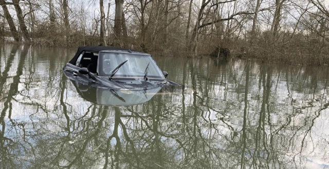
    A Mini car submerged in flood waterImage source, BBC/Martin Eastaugh
    Image caption,

    This Mini is submerged in floodwater on a road in Islip, Oxfordshire, which is currently covered by a flood warning

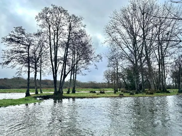
    A flooded field surrounded by treesImage source, BBC Weather Watchers/Janeybeth
    Image caption,

    A wet start this morning in Timsbury, Hampshire as more heavy downpours are expected across the country

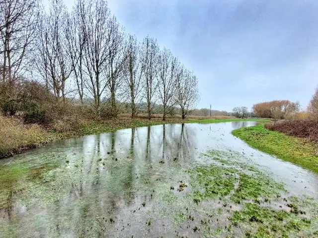
    A flooded field surrounded by treesImage source, BBC Weather Watchers/uwhoandyr
    Image caption,

    A flooded field in Dallington, Northamptonshire

  12. 300 homes and businesses flooded in England - Environment Agencypublished at 10:47 GMT

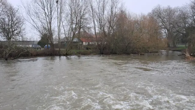
    A flooded river in EssexImage source, BBC Weather Watchers/TEETEE

    The Environment Agency is warning people to "remain vigilant" as it estimates at least 300 properties have been flooded so far following the recent heavy rainfall.

    The agency says its teams "have been mobilised across the country to check on other flood defences", as well as clearing river blockages and monitoring river levels.

    "With another band of rain on its way, we need the public to remain vigilant to the risk of flooding", says Andrew Hitchings, flood duty manager at the Environment Agency.

    "So far more 16000 homes and business have been protected but sadly 300 have suffered flooding and our thoughts are with those communities affected."

    Floods Minster Emma Hardy is also urging residents to follow local advice, and says she's in "regular contact" with the Environment Agency.

  13. Persistent and heavy rainfall - the latest forecastpublished at 10:04 GMT

    Sarah Keith-Lucas
    Lead Weather presenter

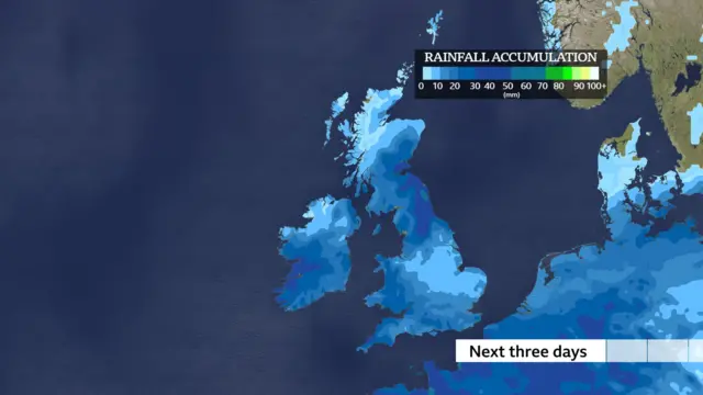
    A map showing expected rainfall accumulation for the next three days
    Image caption,

    This map shows how rainfall is expected to accumulate across the UK

    The unsettled weather pattern is expected to continue for another few days with low pressure systems pushing rain-bearing weather fronts in.

    Tuesday will be another cloudy, damp day across the UK, with further rainfall expected in several flood affected regions.

    The most persistent rain will fall in eastern Scotland where another 40-60mm is possible over higher ground. Heavier downpours are also likely at times for parts of south-west England and Wales. But intermittent showery rain is possible anywhere.

    Wednesday brings further unwelcome rainfall. The focus of the wet weather will be across the northern half of England and once again for Scotland.

    While a further 40-60mm of rain may fall again on Wednesday across eastern Scotland, precipitation here will increasingly turn to snow.

    Further south on Wednesday, rainfall will be more showery in nature with the chance of some brighter and drier spells developing.

    For Thursday and Friday, colder and drier conditions are expected to develop from the north, slowly filtering south.

    Wintry showers are likely in Scotland, and also perhaps the first glimpses of sunshine in Aberdeen for over 20 days.

    Rain and hill snow will gradually start to ease away from most areas, and by Saturday we should see a largely dry but cold day with widespread sunshine.

  14. Send us flooding pictures and weather updates where you livepublished at 09:47 GMT

    How is the wet weather impacting you where you live?

    You can get in touch in the following ways:

    Please read our terms & conditions and privacy policy

    In some cases a selection of your comments and questions will be published, displaying your name and location as you provide it unless you state otherwise. Your contact details will never be published. 

    A red banner with the words 'your voice'
  15. Heavy downpours caused by 'blocked' weather patternpublished at 09:33 GMT

    Heavy downpours are expected across the country caused by a "blocked" weather pattern.

    Blocking patterns are caused mostly due to changes in the jet stream - the fast wind high in the atmosphere.

    In a normal situation the jet stream would flow west to east across the Atlantic with weather systems being created by minor wiggles along it.

    Occasionally the wiggles get bigger and that can result in big curves in the flow - like a meandering river.

    High pressure gets trapped underneath these big curves and the jet stream gets weaker and disrupted.

    The high pressure becomes stronger and gets stuck so the low pressure systems can't push through and get diverted, resulting in the same type of weather for an area for days or weeks.

    Blocked patterns will eventually break, caused by renewed energy in the jet stream or stronger low pressure systems being able to push through the high pressure.

  16. January rainfall in parts of UK breaks more than century-long recordpublished at 09:24 GMT

    Chris Fawkes
    BBC Weather presenter

    A map of January 2026 rainfall totals. In the background, extensive flooding around Fordgate and Moorland in SomersetImage source, Met Office/BBC
    Image caption,

    A map of January 2026 rainfall totals. In the background, extensive flooding around Fordgate and Moorland in Somerset

    We're over a week into a soggy February after Met Office statistics confirmed that Northern Ireland, south-west and southern England, and the east of Scotland all had one of their wettest Januarys on record.

    Northern Ireland saw 70% more rain than average, as it experienced the wettest January for 149 years.

    Culdrose in Cornwall recorded two and a quarter times its average, while Aboyne in Aberdeenshire had nearly four times its January average of 68.9mm.

    Conversely, rainfall across north-west England and west Scotland was below average - the map above shows how the areas coloured brown had less rain than normally expected in January.

  17. Met Office issues yellow warning for parts of Scotlandpublished at 09:18 GMT

    The Met Office has issued a yellow rain warning for parts of eastern Scotland, expected to last until 23:59 GMT on Wednesday.

    "Persistent and at times heavy rain may bring disruption and possible flooding to parts of eastern Scotland through Tuesday", according to the weather agency.

    Here's what's expected:

    • Spray and flooding on roads could cause difficult driving conditions and road closures
    • Flooded roads could also lead to some communities being cut off
    • A small chance of power cuts and loss of services
    • A small chance that homes and businesses may be flooded
    • Possible cancellations or delays to rail or bus services
  18. 103 flood warnings issued as heavy rain to drench parts of UKpublished at 09:07 GMT

    Adam Goldsmith
    Live reporter

    A boat sits on a flooded field with a rainbow in the skyImage source, BBC Weather Watchers/Avondays

    Over one hundred areas of the UK could face flooding as heavy downpours drench parts of the country.

    The wet weather is due to a weather pattern stuck in a "blocked" position for the last few weeks and there are signs of a very brief change before rain returns.

    Rain is expected to come in from the south-west of England, and spread north-east across many parts of England and Wales.

    The Environment Agency has issued 101 flood warnings and 169 flood alerts in England, with saturated ground and already-swollen rivers making flooding more likely.

    There are currently two flood warnings and four alerts in Scotland, and five flood alerts in Wales.

    We'll keep you updated throughout the day with the latest flood warnings and how the weather is impacting areas across the UK.