
I must admit I felt relieved when I pulled back the curtains last Friday and saw snow falling. When I went to bed on Thursday night I felt confident that it would snow.
The computer models had been pretty consistent last week in predicting heavy snow but as a forecaster there is always a risk that things could change last minute, leaving you with egg on your face.
Thankfully though, I think it's fair to say the forecast went according to plan and the amber and red warnings that were issued by the Met Office were justified.
At Tirabad in Powys there was around 26cm, 10 inches, of lying snow by the end of Friday with much bigger drifts.
There were also power cuts in some areas with wet snow sticking to power lines and strong winds bringing them down.
Parts of Wales have had fresh falls of snow yesterday and overnight into this morning, most of it in the northeast of the country. Flintshire has had more snow in the last 24 hours than last Friday!
Most of Wales will have a dry afternoon today bar the odd shower, sleet or snow flurry but there is a risk of more significant snow overnight and tomorrow.
However, unlike last Friday there is a lot more uncertainty in the forecast regarding how much snow we’ll actually get in the next 36 hours and which areas will be worst hit.
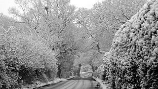
Northop in the snow (photo: Jack Cawley)
Based on the latest information from the Met Office, at the moment there is a 70% risk of significant snow falling in parts of mid, south and west Wales tomorrow.
Five to 10cm, two to four inches, possible in places but in parts of the south and south east there is a 30% risk of over 10cm, four inches. This has the potential to cause further disruption.
The Met Office has issued a yellow warning of snow for parts of south and southeast of Wales tomorrow and this maybe ungraded to an amber warning later today.
Wednesday, Thursday and Friday will be much drier and more settled with just the odd snow shower but it will remain cold with a risk of freezing fog patches.
Ice will continue to be a major hazard with some low temperatures overnight.
Next weekend, looks set to bring a big change as it looks like turning less cold with a spell of wet and windy weather.
Some heavy rain and higher temperatures will lead to a rapid thaw, which could lead to some flooding.
The forecast for tonight and tomorrow could well change as new information comes in later today and give the level of uncertainty it would be an idea to stay tuned for updates on BBC Radio Wales and BBC Wales Today.
You can also follow me on Twitter @derektheweather and if you want to forget about the snow and ice for a while, don’t forget to watch Weatherman Walking on BBC One Wales at 7.30pm.
Take care
Derek
