
It's Shrove Tuesday today and the weather maybe cold but at least it's dry. However, it will be a different story tomorrow!
Low pressure near Iceland, and the remains of the storm that hit the northeast USA - not heading our way but its fronts are - will bring a mixture of rain, sleet and snow followed by milder Atlantic air.
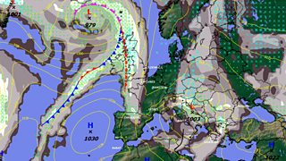
Forecast for 13 February 2013
The worst of the snow is expected to fall in the north, and the Met Office has issued a warning. Over 10cm (4"), of snow is possible on high ground, eg the Berwyn Mountains, with drifting and a risk of some disruption.
Elsewhere, rain is likely on windward coasts in the south and west but inland 1-5cm of snow is likely giving a covering. Most of the snow will accumulate on higher ground such as the Brecon Beacons and the hills of Powys. The snow will last for a few hours but before turning to sleet then rain during the afternoon and evening.
Tomorrow evening will be milder, misty too with rain and drizzle, the rain turning heavier after midnight.
Thursday will start wet but the rain will soon clearing followed by much drier weather, some sunshine and a few scattered showers. It will also feel milder with a westerly breeze and top temperatures 7-9 Celsius.
Thursday night will be dry and turning cold with a touch of frost. Friday should be dry thanks to a ridge of high pressure bringing some sunshine and light winds.
Into the weekend, there may be a few spots of rain or drizzle in the north and west on Saturday otherwise plenty of dry weather seems likely with some sunshine, mist and fog patches and a risk of overnight frost.
Next week, the signs are for a largely dry and settled spell of weather. A welcome change after all the wind, rain and snow we've had this winter.
