
It’s a dry and settled start to the week thanks to high pressure and there’s more dry weather to come this week. Mind you, it’s not a completely dry story because Atlantic fronts will cross the country on Wednesday bringing cloudy, damp and humid air with a little rain and drizzle.
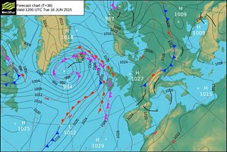
Weather chart - Tuesday 16 June
Tonight will stay dry with clear spells and some high cloud. The wind will remain light with lowest temperatures in the range 9 to 13°C but as low as 8°C in a few rural spots in Powys.
Tomorrow will be a fine, bright day with a few clouds and some high cloud too which will make the sunshine hazy at times. Top temperatures will reach 16 to 21°C; slightly cooler on the south and west coast with a west to south-westerly breeze developing, especially in the northwest.
Wednesday will be a much cloudier and breezier day with moist tropical maritime air. A little rain or drizzle is likely with low cloud, mist and hill fog. The eastern side of the country and the Marches will be drier and brighter with sunny intervals in Monmouthshire. During the afternoon a cold front will bring some rain to north and later mid Wales. Highs 15 to 20°C and it will feel muggy with a west to south-westerly breeze.
On Wednesday night rain and drizzle will spread south and clear leaving Thursday dry and brighter with broken cloud and sunny spells.
It will feel fresher on Thursday with clearer air and lower humidity; highs between 15 and 20°C with a west to north-westerly breeze.
So better weather on Thursday and Friday should also be a reasonable day; dry and bright with patchy cloud and sunny spells. Temperatures on Friday will range from around 15°C on the north and west coast with an onshore breeze to as high as 20°C in the southeast.
Next weekend is expected to have rather mixed weather - a little rain and a few showers but also some drier, brighter conditions as well.
It is worth noting that sea surface temperatures west of the UK and over the mid-Atlantic are a little lower than usual at the moment and some research suggests that this may lead to drier than average conditions across the UK during the summer months!
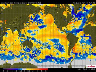
Sea surface temperature chart
