
It’s felt more like summer today (Thursday) with warmer air moving-up from France. In fact, Thursday has been the warmest day of the summer so far. Temperatures rose into the high teens and low 20s this afternoon, 24°C at St Athan in the Vale of Glamorgan and 24°C in Porthmadog in Gwynedd.
Now there's more dry and warm weather to come Friday but it's not going to last. The humidity will continue to rise, with low pressure over France and Spain moving north and bringing some heavy, thundery rain and showers.
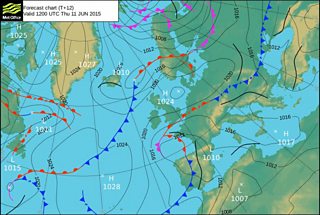
Weather chart for Thursday 11 June
On Thursday most of the country will stay dry but showers in the far south and south-west could be heavy in places with thunder. And a much warmer night than recently, especially in the south.
Friday will bring more dry, warm weather with the best of the hazy sunshine in the north but a few scattered showers are likely in parts of the south and west and later mid-Wales. Again these could be heavy in places with the risk of one or two thunderstorms. Top temperatures will reach 20 to 24°C and it will feel humid. Some coasts in the north and west will be a little cooler with a breeze off the sea.
The grass pollen season is well under way and the pollen count Friday will be very high.
Friday evening more widespread showers and thundery rain will spread north across Wales.
The Met Office has issued a warning of heavy rain and thunderstorms for mid and south Wales.
Torrential downpours are possible in places with a risk of flash flooding, hail, lightning and gusty winds.
On Saturday, much of Wales will be cloudy and wet with outbreaks of rain some of it heavy and thundery in the morning. However, the rain in the far north and north-west may be lighter with perhaps only a little rain on Anglesey. Temperatures will be lower 14 to 18°C with mainly light to moderate winds.
On Saturday night into Sunday, the rain will tend to turn lighter and more sporadic with drier and cooler weather gradually spreading from the north during Sunday. Temperatures will be below average, especially in the north, reaching only 12 to 14°C and 15 to 17°C in the south with a north to north-easterly breeze.
Next week, high pressure will bring plenty of dry weather with only a little rain expected midweek. Temperatures will be on the cool side again with a few more chilly nights and rural grass frost, but in the sunshine it will feel pleasantly warm and there is a hint that it will become warmer next weekend.
