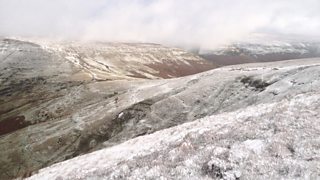
Snow on Hay Bluff by Simon Powell
We’re going to have just about everything thrown us at this week including rain and gales with Met Office warnings in force.
It’s not surprising that we’re in for some rough weather as there is a strong jet stream across the other side of the Atlantic. The jet stream is always strongest during the winter months when the difference in temperature between warm tropical air and cold Arctic air is at its greatest. See the Met Office guide: What is the jet stream?
Tomorrow will start dry but cloud will thicken with some patchy light rain and drizzle spreading across the country during the day. The rain will become more widespread and heavier later in the afternoon. The wind will also increase and it will turn milder; temperatures will eventually reach 9 to 12 Celsius.
Tomorrow evening’s rain will clear to a few blustery showers but it will remain windy, especially in the north and northwest. It will also turn colder with showers again turning wintry on high ground.
Wednesday will continue to be cold and very windy with westerly gales and a mixture of sunshine and showers; the showers will be wintry on higher ground with snow on some hills and mountains in the north.
On Thursday the wind will ease for a time with a few showers but more heavy rain and gales are expected later in the day. Strong to gale force winds this week are likely to cause a few travel problems. On Friday, though, the wind will ease and it will again turn colder with further wintry showers.
Next weekend will remain cold with some sunshine and frost.
