
It’s been very mild recently. On the night of November 9/10th the temperature at Hawarden in Flintshire didn’t fall below 15.7°C - A new record for November!
The reason for the unusually mild weather is down to the wind direction, as south-westerly winds are bringing warm air to our shores from the Tropics. The downside is that those south-westerlies bring a lot of moisture and rain in from the Atlantic.
As the moist air hits the Welsh mountains it is forced upwards, producing more clouds and rain. The technical term for this is orographic enhancement. In fact, rainfall can be as much as 10 times greater over the mountains than on the coast; depending on the strength of the wind and how moist the air is. Most of the rain recently has fallen on the mountains in Snowdonia and this has led to some flooding, for example in the Conwy Valley.
Near Capel Curig in Conwy, around 200mm of rain fell in just a few days: the November average for the whole month is 293mm. Meanwhile, in north-east Wales and the Marches, which are in a rain shadow, much less rainfall was recorded.

Flooding in the Conwy Valley this week; taken by Colin Boyd
Storm Abigail, the first storm to be officially named by the Met Office, will bring some stormy weather and disruption to the north and north-west of Scotland on Thursday night and early on Friday.
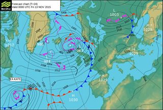
Weather chart for Friday 13 November
Abigail has introduced some colder air on Friday with a mixture of sunshine and blustery showers. Some of the showers will be heavy in places with hail and thunder possible. On the mountain tops the showers will be wintry with sleet and a little snow, the first snow of the season!
Temperatures will be lower than we’ve been used to recently, falling between 8 to 11°C. It will feel much colder in the gusty wind temperatures as low as -9°C on Pen y Fan and -13°C on Snowdon’s summit.

Pen y Fan summit, taken by Anthony de Schoolmeester
Over the weekend, the remains of hurricane Kate over the Atlantic will bring more heavy rain and strong to gale force winds to the UK. Some very heavy and prolonged rainfall is likely in north-west Wales, especially on high ground. 100mm or more rainfall is expected on the mountains and with some rivers already high and swollen, and the ground already saturated, further flooding is likely in places and a yellow warning has been issued.
