

Last week we enjoyed a taste of summer but this week it has felt more like winter again with winds from the Arctic bringing a big drop in temperature, some frost and even a light covering of snow on some hills and mountains including the Brecon Beacons and Snowdonia.
The weather recently has been typical of April with blue sky and sunshine, towering cumulus clouds and showers; the showers have been heavy in places with hail, thunder and even the odd rainbow! But overall this April has been a dry and sunny month with rainfall well below average - see the Met Office Blog
It was exceptionally cold on Sunday night into Monday morning, with temperatures dropping to minus 6° Celsius at Tirabad near Llanwrtyd in Powys.
Looking ahead, Thursday night will be dry with some high cloud, though it will be quite cold with some ground frost inland in mid and north Wales.
The new month will get off to a dry and bright start on Friday with some hazy sunshine but cloud will increase in the south with the odd spot of rain possible over the Bristol Channel. Temperatures will rise to between 10° and 14° Celsius with an east to south-easterly breeze.
Friday night should be dry with increasing cloud. It will be breezy on the south and west coast with lowest temperatures ranging from 4° Celsius in the north and 6 to 8° Celsius on the south coast.
Saturday will be a breezy, windy day. At the moment some dry weather looks likely and it will be bright in the north. However, rain will spread from the south later in the afternoon and evening although it is difficult to predict the timing of its arrival. Top temperatures will be around 10 to 13°Celsius with a fresh to strong east to south-easterly wind; gusts of around 40mph are likely on exposed parts of the south and west coast.
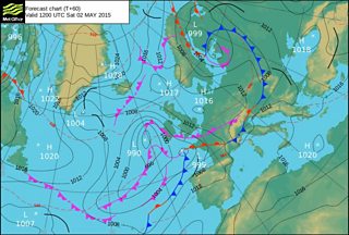
On Sunday more rain and showers (heavy in places) are forecast and low cloud may develop around the south and west coastal areas with some sea fog likely. However, it may become drier and brighten-up from the west later in the day, with some evening sunshine likely in Pembrokeshire. Temperatures on Sunday should rise a little higher reaching 12 to 16° Celsius with a moderate to fresh south-westerly breeze.
Bank holiday Monday should be a better day - it will be drier and brighter with some sunshine although there is a possibility of a few sharp showers. Highest temperatures will be around the seasonal average in the range of 12 to 16° Celsius with a south-westerly breeze.
So very mixed weather is forecast for the bank holiday weekend with low pressure bringing some rain, showers and stronger winds. It shouldn’t however be a total write-off, as it will include some dry, bright weather and a few sunny spells on Monday.
