
It's been a dull few days for Wales, but on the plus side it’s still quite mild for the time of year. The overnight temperatures have been exceeding the daytime average. The grey skies make the perfect backdrop for this picture taken by Weather Watcher Mandy Llewellyn.

Taken by Mandy Llewellyn
Thursday afternoon saw another band of heavy rain sweeping across the country. A yellow ‘be aware’ warning has been in force, with the potential for further flooding. The ground is pretty saturated and the river levels are only just recovering after a very wet few days. The good news is that the rain cleared through the night with lows of 5-8°C. Behind the cold weather front it is drier but rather chilly into the early hours of Friday morning.
Friday starts off chilly with some brightness. Cloud will increase from the west through the afternoon but it should stay dry. Temperatures will reach highs of 10-12°C with brisk south-westerly winds through the afternoon.
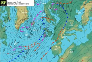
Met Office pressure chart
It’s not looking to be a very nice start to the weekend as you can see from the pressure chart! A big squeeze on the isobars means strong to gale-force winds inland and severe gales along the coast. If that isn't enough we also have heavy rain to go with it. The Met Office has issued a double warning for the strong winds and the heavy rain on Saturday. There is further risk of flooding and travel disruption is very likely.

There is light at the end of the tunnel however! Sunday should see an improvement with the winds easing. Then we can look forward to a mixture of bright spells and a few showers. Make the most of it as we have more unsettled weather in the forecast for next week.
If you are worried about flooding please call the floodline number on 0345 988 1188. Otherwise you can keep up to date with flood warnings in your region online.
