
There was more flooding in parts of Pembrokeshire yesterday and the river Taf in Carmarthenshire has broken its banks at St Clears.

Flooding by Giles Davies
In Tredegar over 180mm (7 inches) of rain has fallen so far this November - that's nearly a month's worth in less than a fortnight!
Thankfully the weather is better today with some sunshine, but it's not dry everywhere, with some heavy showers.
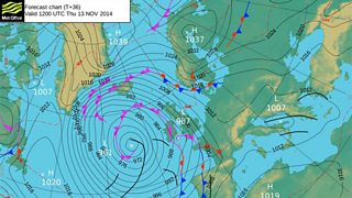
Forecast chart Thursday 13 November
A large area of low pressure over the Atlantic is controlling our weather at the moment with more rain on the way tomorrow, strong winds and gales as well.
The Met Office has issued a yellow wind and rain warning for parts of south and west Wales, north-west Gwynedd and Anglesey.
Wind gusts of 50-60mph are expected. 70mph is possible on exposed coasts around the Irish Sea and hurricane force on the top of Snowdon.
There is a risk of some travel disruption tomorrow. The wind may bring down a few trees and more flooding is possible too, especially in the south and south-west where the ground is already saturated and drains are blocked by fallen leaves.
Later tomorrow afternoon and into the evening, the rain will clear and the wind will ease as well. Tomorrow evening will start dry but another spell of rain and strong winds are expected overnight with a warning in force for mid and south Wales.
On Friday, rain in the morning will clear and it will dry and brighten up from the south with some sunshine. Over the weekend showers in the south and south-west may be heavy and thundery with a risk of further localised flooding. The north should be drier with some sunshine.
