
Anglesey enjoyed nearly nine hours of sunshine yesterday, but it feels more like autumn again today with low pressure bringing cloud, some rain and stronger winds.
Over the weekend, the weather will gradually improve with some bright spells and sunshine but not everywhere will stay dry tomorrow with spots of rain in places and a few showers.
It will be breezy but on Sunday the wind will be lighter and most of the day should be dry thanks to a ridge of high pressure.
It will also feel a little warmer on Sunday; highest temperatures 17 to 20° C with a west to southwesterly breeze.
The Barry Wartime Weekend is taking place this weekend. If you're going along, it looks like Sunday will be the best day weather-wise, while the Rhyl Air Show is on this weekend along with the BBC’s World War One at Home Event for Wales.
Most of the weekend in Rhyl should be dry with lighter winds on Sunday.
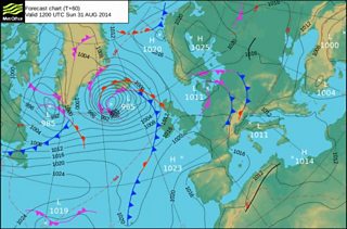
Sunday’s chart shows a deep low pressure near Iceland, the remains of Hurricane Cristobal, with high pressure over the Bay of Biscay.
Forecast chart 29 August 2014
Next week, high pressure will take charge bringing a more settled and warmer spell of weather.
Temperatures will rise into the low to mid 20s Celsius with some sunny spells.
The fine weather may break by the end of the week with a risk of some rain and showers but there is a chance that the warm weather will continue for longer and into the first weekend of September.
