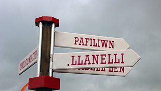
It was a damp start on the Maes in Llanelli this morning but thankfully the showers have cleared and the sun is shining again this afternoon.
Looking ahead, there's more rain on the way tonight spreading across Wales.
Some heavy bursts of rain are likely too, especially in the south and southeast and a Met Office warning has been issued.

A damp start at the Eisteddfod in Llanelli this morning
Tomorrow morning, the rain first thing in the northeast will clear, it will dry and brighten-up, with some sunshine and just one or two showers in the afternoon.
Thursday promises to be a more settled day with lighter winds; most places will be dry with sunny spells although one or two showers may develop in the afternoon.
Friday will start dry but a few showers will break out and there is a risk of rain arriving during the afternoon and evening, especially in the south, east, and into Powys.
As for the weekend, Saturday looks the best day at the moment; sunny spells and mostly dry apart from a few hit-and-miss showers.
On Sunday we could be in for a taste of autumn with a spell of heavy rain and gales, as the remains of ex-tropical storm Bertha moves in from the Atlantic.
There is a lot of uncertainty about the exact track Bertha will take and what impact the storm will have - it may be minimal or it may bring us some unusually wet and windy weather for August – we don’t know yet.
There are differences between the computer models we use to help predict the weather but as we get closer to the weekend we should have a better idea of the likely path that Bertha will take, and be able to fine tune the forecast and issue warnings if required.
