
After a very sunny April, this month has been cooler and wetter than average with only a few nice days. Cardiff was the warmest place in the UK last Tuesday with a high of 20°C but overall it has been a cool month. Over the next few days, the changeable weather will continue with temperatures remaining below average for late spring.
On Thursday evening, showers are likely in mid and north Wales with rain, heavy in places, spreading from the west after midnight. Friday will start wet but the rain will clear south-eastwards later in the morning leaving a drier and brighter afternoon, with a mixture of sunshine and scattered showers. Temperatures will be below average again - only 11 to 15°C with a cool west to north-westerly breeze.
If you’re going to the Urdd Eisteddfod on Friday, rain will clear later in the morning followed by sunny spells and the odd shower. It'll feel cool and breezy with a high of around 13°C.
Friday night will see a mixture of clear spells and showers, heavy in places with hail. Later in the night most of the country should become dry and chilly with a few showers in the north. Lowest temperatures will range between 4 to 7°C.
Saturday will be a better day thanks to a ridge of high pressure; maybe a few showers in the north first thing, otherwise dry with some bright spells and sunshine. However, it may cloud over later in the afternoon with a little rain in the south and west before evening. Temperatures on Saturday should reach 12 to 16°C with lighter winds.
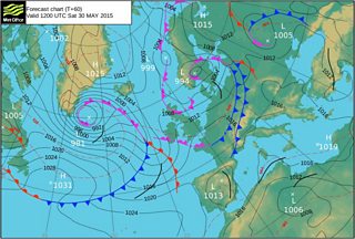
Met Office Pressure Chart Sat 30 May
On Saturday night into Sunday the weather will go downhill, turning wet and windier with a spell of heavy rain. Between 20 and 40mm of rain is likely on higher ground. Sunday will start wet but it should dry and brighten-up from the west by midday with a better afternoon and evening.
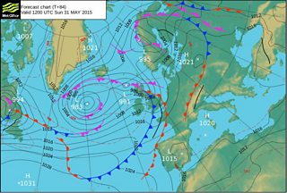
Met Office Pressure Chart Sun 31 May
Next week poor and cool weather is likely for the start of June with low pressure bringing some heavy rain, blustery showers and strong winds. However, the weather looks set to improve from Wednesday onwards. The jet stream will move further north, pressure will rise and it start to warm-up with the arrival of summer – at long last!
