
We've had some cold and frosty nights this week. In Tirabad in Powys and Trawsgoed in Ceredigion the temperature fell as low as minus 5°C, the lowest temperature recorded so far this year!
Aberporth enjoyed seven hours of sunshine on Wednesday but yesterday much of Wales was covered by a blanket of cloud.
Today will dry and brighten up; we'll all see some sunshine with scattered showers in the afternoon. In the north and west the showers may be heavy in places with hail and it will be wintry on higher ground with a little snow on the mountains. Top temperatures will reach 5 to 8°C with a chilly north-westerly breeze.
Tonight will see a few scattered showers, wintry in places. Otherwise a lot of dry, clear weather, the wind will ease too with some frost, mist and fog forming. There is also a risk of a few icy patches.

Frosty morning in Cosheston by Grace Davies
On Saturday mist and fog patches in the morning will lift. There'll be some dry, bright weather with the best of the sunshine in the east. However, a little rain is likely in Gwynedd and elsewhere cloud will increase with a few showers in the south and west. The breeze will pick up in the north-west and it will turn milder with temperatures rising to 7°C in Presteigne and 10°C in Aberystwyth.
On Saturday night into Sunday an active cold front will move south-east across the UK followed by another shot of cold air from the Arctic. Sunday will start wet but the rain will clear followed by sunshine and showers. A breezy/windy day and turning colder with temperatures dropping during the day.
Some of the showers on Sunday will be wintry in nature with sleet and snow on higher ground. Slight accumulations of snow are likely in upland areas and on the mountains.
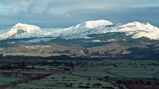
Snow on the Snowdonia mountains by Eddie Evans, Harlech
Next week low pressure will bring some wind and rain. Temperatures will vary from mild to cold with some sunshine and wintry showers. In other words, a real mix and typical December weather.
