Full coverage
Skip to main contentAccess keys help

[an error occurred while processing this directive]
BBC News
watch One-Minute World News
News imageNews imageNews image
Click on the links below to see maps tracing the history of the Israeli-Palestinian conflict
News imageNews imageNews imageNews imageNews imageNews imageNews image
Introduction
News image
Pre-1947:
British control
News image
1947-1949:
Israel founded
News image
1967:
Six-Day War
News image
Jerusalem:
Before 1967 & now
News image
West Bank:
Autonomy & population
News image
West Bank:
Settlements & checkpoints
News image
Gaza:
Population and security
News image
News imageNews imageNews image
News image
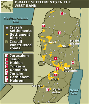
West Bank: Israeli settlements
Since 1967, Israel has pursued a policy of building settlements on the West Bank. These cover about 2% of the area of the West Bank and are linked by Israeli-controlled roads. There are also large tracts of Israeli-controlled land designated as military areas or nature reserves.
News image
West Bank: Israeli checkpoints
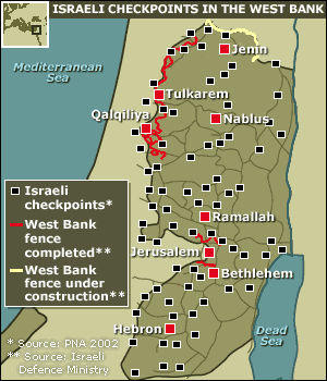
Military checkpoints on West Bank roads allow Israel to monitor and control travel in much of the West Bank. During the recent Palestinian intifada, Israeli troops have also encircled and staged incursions into population centres and severely restricted the movement of Palestinian civilians. In 2002, Israel began building a security barrier near the north-western edge of the West Bank.

PRODUCTS AND SERVICES

AmericasAfricaEuropeMiddle EastSouth AsiaAsia Pacific