Gaza Strip: Population
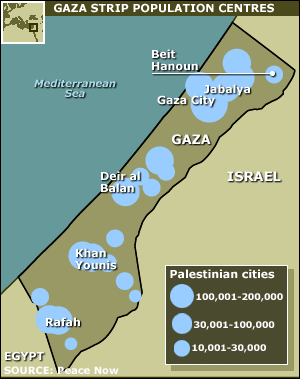
Gaza, one of the most densely populated tracts of land in the world, is home to about 1.3m Palestinians, about 33% of whom live in United Nations-funded refugee camps. About 8,000 Jewish settlers also lived in the Gaza Strip until September 2005 when they and the troops that protected them were withdrawn. Before the withdrawal, travel in and out of Gaza was severely restricted for long periods. |  | Gaza Strip: Access and security
Israel controls Gaza's airspace, coast and most of its borders. In November 2005 Israel agreed to allow the Palestinians and Egypt to control the Rafah crossing point (with video surveillance by an EU-Palestinian team), and to increase traffic through Erez and Karni crossing points. The construction of a sea port was also given the go-ahead. The future of Gaza's destroyed airport is yet to be agreed. |