Full coverage
Skip to main contentAccess keys help

[an error occurred while processing this directive]
BBC News
watch One-Minute World News
News imageNews imageNews image
Click on the links below to see maps tracing the history of the Israeli-Palestinian conflict
News imageNews imageNews imageNews imageNews imageNews imageNews image
Introduction
News image
Pre-1947:
British control
News image
1947-1949:
Israel founded
News image
1967:
Six-Day War
News image
Jerusalem:
Before 1967 & now
News image
West Bank:
Autonomy & population
News image
West Bank:
Settlements & checkpoints
News image
Gaza:
Population and security
News image
News imageNews image
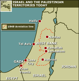
Introduction

At the heart of the Israeli-Palestinian conflict is a dispute over land and borders. The geography of the conflict revolves around the three territorial units of Israel, the West Bank and Gaza, defined by armistice lines drawn after a war in the region in 1948. Since then, military action, settlement and population growth have also shaped the situation on the ground.

BBC News Online explores the conflict by comparing maps of the region over time

PRODUCTS AND SERVICES

AmericasAfricaEuropeMiddle EastSouth AsiaAsia Pacific