| | The Ridgeway | |
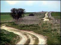
Described as Britain's Oldest Road, the Ridgeway is a 85 mile (137km) route that follows the chalk hills between Overton Hill, near Avebury and Ivinghoe Beacon in Hertfordshire. The route was used by prehistoric man and has been described by some as being as important as today's modern roads. Despite being popular with walkers, part of the route is open to motorised vehicles, which has resulted in additional wear and tear and, consequently, temporary closure of parts of the route. | | Thoughts and Theories | |
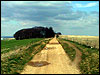 The Wiltshire stretch of the Ridgeway is the most remote section of the entire route and runs along the ridge of archaeologically rich downland between Overton Hill and Uffington White Horse, on the Oxfordshire borders. The Wiltshire stretch of the Ridgeway is the most remote section of the entire route and runs along the ridge of archaeologically rich downland between Overton Hill and Uffington White Horse, on the Oxfordshire borders.
The route has been in constant use for 4000 years and some believe it continued beyond Wiltshire, heading south into Dorset and on to the coast. Many observers have noted the proximity of the Ridgeway with the rash of crop circles that have emerged in the countryside alongside the route. 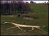 They argue that this connection, coupled with the nearness of ancient sites, such as Avebury and The Sanctuary, proves the significance of The Ridgeway as a way of connecting these important religious sites. They argue that this connection, coupled with the nearness of ancient sites, such as Avebury and The Sanctuary, proves the significance of The Ridgeway as a way of connecting these important religious sites.
| | Multimedia | |
GALLERY:
Click here for The Moonraking Gallery | | Add Your View | |
Ridgeway
http://www.ridgewaywalk.co.uk/ Neil Jordan
I have used the Ridgeway for over 15years on a weekly basis. There is absolutely no doubt that the damage to the surface of the track has deteriorated over the last few years in direct correlation to the rise in use of SUV's. Some damage has always been due to agricultural vehicles but this has historically been limited to certain sections. The more widespread damage is due to off road motorcycles and SUVs. Andy Baxter
I think people should have more tolerance for other users of the Ridgeway. Split it down the middle. Half for walkers/Horse riders and the other half for 4x4 and bikes. Solution: Ramblers boots have grass, tyres get mud. Pat Rudkins
I feel the Ridgeway should be closed to motorists to minimise damage and maintain a pleasant environment for walkers martin
how do you find the rigdeway path in wiltshire? FROM BBC WILTSHIRE: The path runs from Barbury Ashbury, to the east of Swindon and heads south towards the A4 close to Overton Hill between Avebury and Marlborough.
| | How to find it | |
The start/end of The Ridgeway in Wiltshire, lies off the A4 between Marlborough and Avebury, close to West Overton. Ordnance Survey: SU119681
Click here to see Multimap location
The BBC is not responsible for the content of external websites.
|