| | West Kennett Long Barrow | |
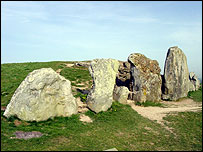
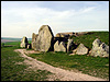
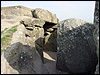
West Kennett Long Barrow dates back to 3500 BC and is one of the best preserved barrows in the country - it is also one of the largest. It measures over 90 metres (300 feet) in length and is nearly 24 metres (80 feet) wide. The barrow is 'blocked' at its eastern end by several large sarsen stones - the largest of which is over three metres (12 feet) high. Inside, a chamber, 12 metres (40 feet) in length is divided into five distinct chambers. When it was excavated in the 1950s, the remains of between 40 and 50 people were discovered - some of which were children. The oldest of the remains were dated back to 2570 BC and the barrow itself was in use for around a thousand years. | | Thoughts and Theories | |
 It seems that of the relics recovered from the tomb, only incomplete skeletons were found, the implication being that the missing bones (skulls and limbs) were used for ritualistic purposes. It seems that of the relics recovered from the tomb, only incomplete skeletons were found, the implication being that the missing bones (skulls and limbs) were used for ritualistic purposes.
Back in the 1600s, despite dire warnings of ghostly hounds haunting the area, the barrow was raided by a local doctor and the bones found within used to create patent medicines. 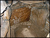 Ley-hunter, Paul Devereux, writing in his book Symbolic Landscapes, notes that the westward extension of West Kennett Long Barrow coincided with the construction of nearby Silbury Hill. He goes on to suggest that, as a result, a clear view towards Silbury, Avebury and the Neolithic settlement at Windmill Hill beyond emerged and asserts that this visual 'fix' would have been symbolic for Neolithic man. Ley-hunter, Paul Devereux, writing in his book Symbolic Landscapes, notes that the westward extension of West Kennett Long Barrow coincided with the construction of nearby Silbury Hill. He goes on to suggest that, as a result, a clear view towards Silbury, Avebury and the Neolithic settlement at Windmill Hill beyond emerged and asserts that this visual 'fix' would have been symbolic for Neolithic man.
 When measuring the monument's 'ley structure', Martin Newman located an energy centre inside the chamber. He wrote: "here someone had placed in the stones a small bunch of wild flowers. When I saw the flowers it really made my heart skip a beat, it was like an offering placed there for the earth mother." Quoted from Mysterious Wiltshire. When measuring the monument's 'ley structure', Martin Newman located an energy centre inside the chamber. He wrote: "here someone had placed in the stones a small bunch of wild flowers. When I saw the flowers it really made my heart skip a beat, it was like an offering placed there for the earth mother." Quoted from Mysterious Wiltshire.
| | Multimedia | |
GALLERY:
Click here for The Moonraking Gallery. | | Add Your View | |
| | How to find it | |
West Kennett Long Barrow lies about a quarter of a mile to the south of the A4 between Marlborough and Beckhampton. Ordnance Survey: SU100675
Click here to see Multimap location
The BBC is not responsible for the content of external websites
|